File:Armidale Regional Airport, New South Wales (10005706805).jpg
Jump to navigation
Jump to search

Size of this preview: 800 × 534 pixels. Other resolutions: 320 × 213 pixels | 640 × 427 pixels | 1,024 × 683 pixels.
Original file (1,024 × 683 pixels, file size: 541 KB, MIME type: image/jpeg)
Captions
Captions
Add a one-line explanation of what this file represents
Summary
[edit]| Description |
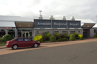
English: Armidale Airport (IATA: ARM, ICAO: YARM) is an airport serving Armidale, a city in the Australian state of New South Wales. It is located 3.7 kms southwest of the town centre, on New England Highway. The airport is operated by the Armidale Dumaresq Shire Council. The airport resides at an elevation of 3,556 ft (1,084 m) above mean sea level. It has two runways: 05/23 with an asphalt surface measuring 1,738 m × 30 m (5,702 ft × 98 ft) and 09/27 with a grassed gravel surface measuring 1,116 m × 30 m (3,661 ft × 98 ft). QantasLink operates up to five services a day using Q300 aircraft. It is expected that in the future, selected services may be operated by Q400 aircraft - Armidale Regional Airport, New South Wales. File: Terminal_YARM_20090311_5110
|
| Date | |
| Source | https://www.flickr.com/photos/robertfrola/10005706805/ |
| Author | Robert Frola |
| Camera location | | View this and other nearby images on: OpenStreetMap |
|---|
Licensing
[edit]This file comes from the Robert Frola collection and is copyrighted.
Note: This permission only extends to photos taken by Robert Frola at this link, this link, and this link, in addition to files which may be provided via email. It does not include any other content from the above sites which has not been provided by Robert Frola.
|

.jpg&action=edit§ion=1)
.jpg¶ms=-30.529620_N_0151.617980_E_globe:Earth_type:camera__&language=en)
.jpg&action=edit§ion=2)
The making of this file was supported by Wikimedia UK.
To see other files made with the support of Wikimedia UK, please see the category Supported by Wikimedia UK.
|
File history
Click on a date/time to view the file as it appeared at that time.
| Date/Time | Thumbnail | Dimensions | User | Comment | |
|---|---|---|---|---|---|
| current | 09:38, 25 April 2014 | | 1,024 × 683 (541 KB) | Fæ (talk | contribs) | == {{int:filedesc}} == {{information |description={{en|1=Armidale Airport (IATA: ARM, ICAO: YARM) is an airport serving Armidale, a city in the Australian state of New South Wales. It is located 3.7 kms southwest of the town centre, on New England High... |
You cannot overwrite this file.
File usage on Commons
The following 2 pages use this file:
File usage on other wikis
The following other wikis use this file:
- Usage on ar.wikipedia.org
- Usage on ast.wikipedia.org
- Usage on ceb.wikipedia.org
- Usage on en.wikipedia.org
- Usage on en.wikivoyage.org
- Usage on es.wikipedia.org
- Usage on gl.wikipedia.org
- Usage on id.wikipedia.org
- Usage on nl.wikipedia.org
- Usage on ro.wikipedia.org
- Usage on sv.wikipedia.org
- Usage on www.wikidata.org
.jpg&oldid=801737792)