File:Armenian population map 1896 cropped 3.jpg
Jump to navigation
Jump to search
No higher resolution available.
Armenian_population_map_1896_cropped_3.jpg (787 × 539 pixels, file size: 279 KB, MIME type: image/jpeg)
Captions
Captions
Add a one-line explanation of what this file represents
|
|

Summary
[edit]| Description |
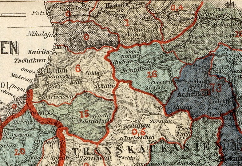
English: The Armenian population in historical Armenian regions in 1896. The Armenian population in represented in the colored areas, as well as in the red Arabic numbers, indicating their exact percentage. |
| Date | (UTC) |
| Source | |
| Author |
|

| This is a retouched picture, which means that it has been digitally altered from its original version. The original can be viewed here: Armenian population map 1896.jpg:
|
Licensing
[edit]
|
This work is in the public domain in its country of origin and other countries and areas where the copyright term is the author's life plus 70 years or fewer. | |
| This file has been identified as being free of known restrictions under copyright law, including all related and neighboring rights. | |
Original upload log
[edit]
This image is a derivative work of the following images:
- File:Armenian_population_map_1896.jpg licensed with PD-old
- 2009-11-15T15:41:59Z Alex:D 2964x2460 (3015501 Bytes) whitened
- 2008-06-14T14:57:07Z Olahus 2964x2460 (4155406 Bytes) {{Information |Description={{en|1=The Armenian population in hostorical Armenian regions in the year 1896.}} |Source=Petermanns Mitteilungen |Author=own scan |Date=1896 |Permission= |other_versions= }} {{ImageUpload|full}}
Uploaded with derivativeFX
| Annotations | This image is annotated: View the annotations at Commons |
File history
Click on a date/time to view the file as it appeared at that time.
| Date/Time | Thumbnail | Dimensions | User | Comment | |
|---|---|---|---|---|---|
| current | 01:51, 12 September 2010 | | 787 × 539 (279 KB) | Geagea (talk | contribs) | {| width="100%" style="background-color: transparent;" |- valign="top" | 400px |} == {{int:filedesc}} == {{Information |Description={{en|1=The Armenian population in historical Armenian regions in 18 |
You cannot overwrite this file.
File usage on Commons
There are no pages that use this file.
Metadata
Categories:
- German-language maps of the Caucasus
- 1890s maps of Armenia
- 1890s maps of Georgia
- Ottoman Armenian population
- Old maps of the South Caucasus
- Maps of Batum Oblast
- Old maps of oblasts of the Russian Empire
- Akhaltsikhe Municipality
- Akhalkalaki Municipality
- Old maps of Viceroyalty of the Caucasus
- 1896 maps of the Russian Empire
- Details of old maps of the Caucasus