File:Armenian Genocide Map-fr.svg
Jump to navigation
Jump to search

Size of this PNG preview of this SVG file: 800 × 393 pixels. Other resolutions: 320 × 157 pixels | 640 × 314 pixels | 1,024 × 503 pixels | 1,280 × 629 pixels | 2,560 × 1,257 pixels | 2,574 × 1,264 pixels.
Original file (SVG file, nominally 2,574 × 1,264 pixels, file size: 518 KB)
Captions
Captions
Add a one-line explanation of what this file represents
Summary
[edit]| Description |
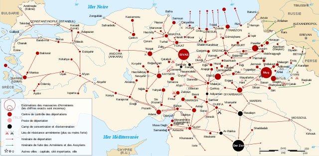
English: French map of the Armenian Genocide in 1915. Español: Mapa del genocidio armenio en 1915. Français : Carte du génocide arménien en 1915.
Русский: Карта геноцида армян 1915 года. |
| Date | |
| Source |
Own work Sources :
Autres informations :
|
| Author | Sémhur |
| Other versions |
[]
|
| Attribution (required by the license) | © Sémhur / Wikimedia Commons / |
| SVG development | This map is translated using SVG switch elements: all translations are stored in the same file. |


| Camera location | | View this and other nearby images on: OpenStreetMap |
|---|
Licensing
[edit]
I, the copyright holder of this work, hereby publish it under the following licenses:
| Copyleft: This work of art is free; you can redistribute it and/or modify it according to terms of the Free Art License. You will find a specimen of this license on the Copyleft Attitude site as well as on other sites. |
This file is licensed under the Creative Commons Attribution-Share Alike 4.0 International, 3.0 Unported, 2.5 Generic, 2.0 Generic and 1.0 Generic license.
- You are free:
- to share – to copy, distribute and transmit the work
- to remix – to adapt the work
- Under the following conditions:
- attribution – You must give appropriate credit, provide a link to the license, and indicate if changes were made. You may do so in any reasonable manner, but not in any way that suggests the licensor endorses you or your use.
- share alike – If you remix, transform, or build upon the material, you must distribute your contributions under the same or compatible license as the original.
You may select the license of your choice.
File history
Click on a date/time to view the file as it appeared at that time.
| Date/Time | Thumbnail | Dimensions | User | Comment | |
|---|---|---|---|---|---|
| current | 21:41, 26 April 2021 | | 2,574 × 1,264 (518 KB) | ChrisPtDe (talk | contribs) | File uploaded using svgtranslate tool (https://svgtranslate.toolforge.org/). Added translation for frp. |
| 22:05, 8 March 2021 |  | 2,574 × 1,264 (486 KB) | 4nn1l2 (talk | contribs) | ISTANBUL to "CONSTANTINOPLE (ISTANBUL)" per this // Editing SVG source code using c:User:Rillke/SVGedit.js | |
| 09:46, 9 February 2008 |  | 2,574 × 1,264 (486 KB) | Sémhur (talk | contribs) | orthographe : GRÉCE => GRÈCE | |
| 18:59, 6 February 2008 |  | 2,574 × 1,264 (486 KB) | Sémhur (talk | contribs) | {{Information |Description= {{en|French map of the Armenian genocide in 1915.}} {{fr|carte du génocide arménien en 1915.}} |Source=travail personnel. Sources : * Fond de carte : [http://www2.jpl.nas |
You cannot overwrite this file.
File usage on Commons
The following 19 pages use this file:
- User:Magog the Ogre/Maps of conflicts/2021 April
- User:Magog the Ogre/Maps of conflicts/2021 March
- Commons:Graphic Lab/Map workshop/Archive/2021
- File:Armenian Genocide Map-ar.svg
- File:Armenian Genocide Map-el.jpg
- File:Armenian Genocide Map-en.svg
- File:Armenian Genocide Map-es.svg
- File:Armenian Genocide Map-fr.svg
- File:Armenian Genocide Map-frp.svg
- File:Armenian Genocide Map-hu.svg
- File:Armenian Genocide Map-hy.svg
- File:Armenian Genocide Map-id.svg
- File:Armenian Genocide Map-mk.svg
- File:Armenian Genocide Map-ro.svg
- File:Armenian Genocide Map-ru.svg
- File:Armenian Genocide Map-sr-ec.svg
- File:Armenian Genocide Map-tr.svg
- File:Armeniangenocidemap.gif
- Template:Other versions/Armenian Genocide Map
File usage on other wikis
The following other wikis use this file:
- Usage on fr.wikipedia.org
- Génocide arménien
- Hussein ben Ali (roi du Hedjaz)
- Mehmed V
- Ismail Enver
- Organisation spéciale (Empire ottoman)
- Mehmed VI
- Négation du génocide arménien
- Arménie occidentale
- Nombre de victimes du génocide arménien
- Déclin et chute de l'Empire ottoman
- Chronologie du génocide arménien
- Talaat Pacha
- Djemal Pacha
- Utilisateur:Hayastan07/Portail:Histoire de l'Arménie
- Utilisateur:Hayastan07/Portail:Histoire de l'Arménie/Lumière sur
- Documents Andonian
- Tsitsernakaberd
- Massacres hamidiens
- Pierre Quillard
- Bibliographie sur le génocide arménien
- Population arménienne ottomane
- Wikipédia:Atelier graphique/Cartes/Archives/février 2008
- Opération Némésis
- Reconnaissance politique du génocide arménien
- Chronologie de l'Arménie
- Pont (région)
- Portail:Arménie/Séries
- Portail:Arménie/Série du mois/avril
- Azad (téléfilm)
- Massacres d'Adana
- Modèle:Palette Génocide arménien
- Histoire de l'Arménie
- Aghet : 1915, le génocide arménien
- Doktor Nâzım
- Loi française relative à la reconnaissance du génocide arménien de 1915
- Wikipédia:RAW/2013-05-12
- Question arménienne
- Maria Jacobsen
- Empire ottoman dans la Première Guerre mondiale
- Liste de mémoriaux du génocide arménien
- Rafle des intellectuels arméniens du 24 avril 1915 à Constantinople
- Journée de commémoration du génocide arménien
- Loi Tehcir
- Behaeddine Chakir
- Manifestation du 24 avril 1965 à Erevan
- Centième anniversaire du génocide arménien
- Génocide arménien dans la culture
- Procès d'Istanbul de 1919-1920
- Exilés de Malte
- Wikipédia:Wikiconcours/mars 2015/Équipes
View more global usage of this file.