File:ArmaenCaldas.png
Jump to navigation
Jump to search
Size of this preview: 788 × 600 pixels. Other resolutions: 315 × 240 pixels | 631 × 480 pixels | 1,009 × 768 pixels | 1,280 × 974 pixels | 2,300 × 1,751 pixels.
Original file (2,300 × 1,751 pixels, file size: 3.5 MB, MIME type: image/png)
Captions
Captions
Add a one-line explanation of what this file represents
| Description |
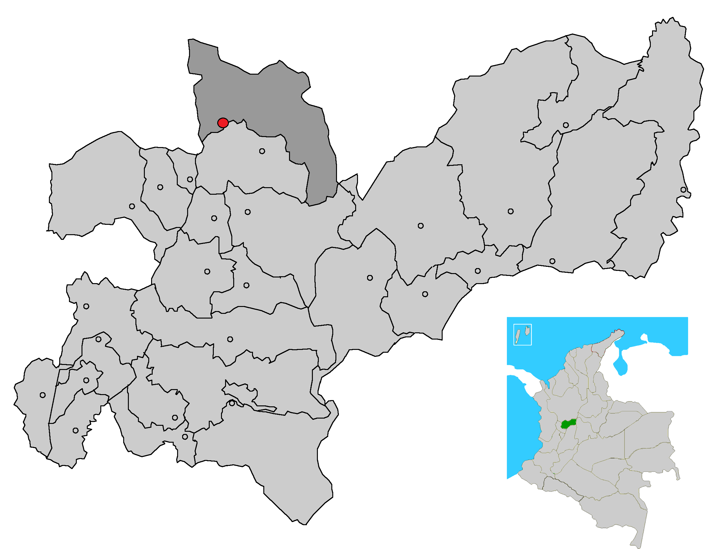
Image depicting map location of the town and municipality of Aguadas in Caldas Department, Colombia
|
| Date | (UTC) |
| Source | |
| Author |
|
| This is a retouched picture, which means that it has been digitally altered from its original version. Modifications: just fusioned the two pics to make an exactly pointing of Arma, Caldas's Location on the map without deleting the other municipalities in Caldas. The original can be viewed here: CorregimArmaAguadas.png:
|
This file is licensed under the Creative Commons Attribution-Share Alike 3.0 Unported license.
- You are free:
- to share – to copy, distribute and transmit the work
- to remix – to adapt the work
- Under the following conditions:
- attribution – You must give appropriate credit, provide a link to the license, and indicate if changes were made. You may do so in any reasonable manner, but not in any way that suggests the licensor endorses you or your use.
- share alike – If you remix, transform, or build upon the material, you must distribute your contributions under the same or compatible license as the original.
Original upload log
[edit]
This image is a derivative work of the following images:
- File:MunsCaldas_Aguadas.png licensed with Cc-by-2.5, Cc-by-sa-3.0-migrated, GFDL
- 2007-04-27T20:24:07Z F3rn4nd0 2300x1751 (3583471 Bytes) {{Information |Description=Image depicting map location of the town and municipality of Aguadas in Caldas Department, Colombia |Source=own work |Date=04.27.2007 |Author=--~~~~ |Permission=GFDL - CC attribution |other_versions
- File:CorregimArmaAguadas.png licensed with Cc-by-2.5, Cc-by-sa-3.0-migrated, GFDL
- 2011-05-04T22:46:11Z Cefero3 600x584 (6419 Bytes) {{Information |Description=Image depicting map location of the town and municipality of Aguadas in Caldas Department, Colombia |Source=*[[:File:MunsCaldas_Aguadas.png|]] |Date=2011-05-04 22:42 (UTC) |Author=*[[:File:MunsCalda
Uploaded with derivativeFX
File history
Click on a date/time to view the file as it appeared at that time.
| Date/Time | Thumbnail | Dimensions | User | Comment | |
|---|---|---|---|---|---|
| current | 03:32, 11 May 2011 | | 2,300 × 1,751 (3.5 MB) | Cefero3 (talk | contribs) | {{Information |Description=Image depicting map location of the town and municipality of Aguadas in Caldas Department, Colombia Just pointing out Arma Caldas on it instead of Aguadas from the original one, just for information purposses |Source=*[[:File: |
You cannot overwrite this file.
File usage on Commons
There are no pages that use this file.