File:Argentina Córdoba location map.svg
Jump to navigation
Jump to search

Size of this PNG preview of this SVG file: 390 × 600 pixels. Other resolutions: 156 × 240 pixels | 312 × 480 pixels | 499 × 768 pixels | 665 × 1,024 pixels | 1,331 × 2,048 pixels | 650 × 1,000 pixels.
Original file (SVG file, nominally 650 × 1,000 pixels, file size: 236 KB)
Captions
Captions
Add a one-line explanation of what this file represents
No llega la información que quiero Es el lugar La Plblacion y se encuentra tra en la Pcia de Cba.Por Fabor.
Summary
[edit]| Description |
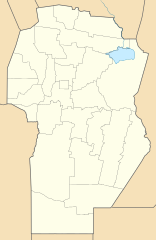
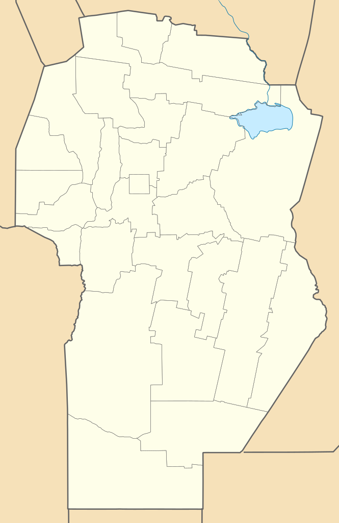
Deutsch: Positionskarte von Córdoba (Argentinien) English: Location map of Córdoba province (Argentina) Español: Mapa de localización de la Provincia de Córdoba.
Equirectangular projection, N/S stretching 117.5 %. Geographic limits of the map:
|
| Date | (UTC) |
| Source |
This file was derived from: |
| Author | |
| Other versions |
|
| SVG development |

Licensing
[edit]
This file is licensed under the Creative Commons Attribution-Share Alike 3.0 Unported license.
- You are free:
- to share – to copy, distribute and transmit the work
- to remix – to adapt the work
- Under the following conditions:
- attribution – You must give appropriate credit, provide a link to the license, and indicate if changes were made. You may do so in any reasonable manner, but not in any way that suggests the licensor endorses you or your use.
- share alike – If you remix, transform, or build upon the material, you must distribute your contributions under the same or compatible license as the original.
Original upload log
[edit]
This image is a derivative work of the following images:
- File:Argentina location map.svg licensed with Cc-by-sa-3.0, GFDL
- Map of Cordoba Province, Argentina.svg licensed with Cc-by-sa-3.0,2.5,2.0,1.0, GFDL
Uploaded with derivativeFX
File history
Click on a date/time to view the file as it appeared at that time.
| Date/Time | Thumbnail | Dimensions | User | Comment | |
|---|---|---|---|---|---|
| current | 02:42, 10 September 2017 | | 650 × 1,000 (236 KB) | Milenioscuro (talk | contribs) | capas |
| 14:50, 7 July 2013 |  | 650 × 1,000 (365 KB) | Milenioscuro (talk | contribs) | == {{int:filedesc}} == {{Information |Description={{de|Positionskarte von Catamarca (Argentinien)}}{{en|Location map of Catamarca province (Argentina)}}{{es|1=Mapa de localización de la Provincia de Catamarca.}} E... |
You cannot overwrite this file.
File usage on Commons
The following 10 pages use this file:
- File:Argentina Córdoba topographic location map.png
- Category:Births in Córdoba Province, Argentina
- Category:Cities in Córdoba Province, Argentina
- Category:Córdoba Province, Argentina
- Category:Dams in Córdoba Province, Argentina
- Category:Departments of Córdoba Province, Argentina
- Category:Maps of Córdoba Province, Argentina
- Category:Museums in Córdoba Province, Argentina
- Category:Train stations in Córdoba Province, Argentina
- Category:Transport in Córdoba Province, Argentina
File usage on other wikis
The following other wikis use this file:
- Usage on de.wikipedia.org
- Usage on en.wikipedia.org
- Córdoba, Argentina
- Villa María, Córdoba
- Río Cuarto, Córdoba
- Santa Rosa de Calamuchita
- Río Ceballos
- Embalse, Argentina
- Bell Ville
- San Francisco, Córdoba
- Arroyito, Córdoba
- Quinto River
- Quebracho Herrado, Argentina
- Corral Quemado, Córdoba
- Ticino, Argentina
- General Cabrera
- General Deheza
- Las Perdices
- Dalmacio Vélez Sarsfield, Argentina
- Carnerillo
- Module:Location map/data/Argentina Córdoba Province
- Module:Location map/data/Argentina Córdoba Province/doc
- Achiras
- Adelia María
- Agua de Oro
- Tío Pujio
- Arroyo Cabral
- Villa Nueva, Córdoba
- La Granja, Argentina
- Brinkmann, Córdoba
- Matorrales
- Usage on eo.wikipedia.org
View more global usage of this file.