File:Areal view Rhine Bridge Mannheim-Ludwigshafen 1945.jpg
Jump to navigation
Jump to search

Size of this preview: 786 × 600 pixels. Other resolutions: 315 × 240 pixels | 629 × 480 pixels | 1,007 × 768 pixels | 1,280 × 976 pixels | 2,643 × 2,016 pixels.
Original file (2,643 × 2,016 pixels, file size: 2.41 MB, MIME type: image/jpeg)
Captions
Captions
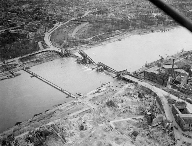
Rhine near Mannheim and Ludwigshafen with destroyed Rhine bridge and pontoon bridge in 1945
Summary
[edit]
| Description |
Deutsch: Luftaufnahme aus unbekannter Quelle der U.S. Air Force, Ende März / Anfang April 1945. Blick von über der Innenstadt von Ludwigshafen am Rhein zur Rheinbrücke. Diese war am 20. März 1945 durch die deutsche Wehrmacht gesprengt worden, als sich die Aliierten gegen Kriegsende Mannheim näherten. Schon kurz danach wurde etwas flussabwärts durch die US-Army eine Pontonbrücke errichtet. (Auf dem Bild links von der zerstörten Brücke zu sehen). Das Bild stammt aus der Zeit bevor Ende April 1945 die Eisenbahn-Notbrücke errichtet wurde. Das Luftbild stammt aus der Sammlung "World War II Images" des "San Diego Air & Space Museum" und wurde mit dem Hinweis "No known copyright restrictions" versehen.]
English: Aerial view from Ludwigshafen am Rhein to the destroyed Rhine bridge between Ludwigshafen and Mannheim at the end of March / beginning of April 1945.] |
| Date | |
| Source | https://www.trolley-mission.de/de/mannheim-1945-luftaufnahme-barockschloss-universitaet-hauptbahnhof-rheinbruecke from the collection "World War II Images" of the "San Diego Air & Space Museum" |
| Author | unknown member of the U.S. Air Force |
| Permission (Reusing this file) |
public domain |
| Camera location | | View this and other nearby images on: OpenStreetMap |
|---|
Licensing
[edit]
This image or file is a work of a U.S. Air Force Airman or employee, taken or made as part of that person's official duties. As a work of the U.S. federal government, the image or file is in the public domain in the United States.
|
 |
File history
Click on a date/time to view the file as it appeared at that time.
| Date/Time | Thumbnail | Dimensions | User | Comment | |
|---|---|---|---|---|---|
| current | 17:01, 6 October 2021 | | 2,643 × 2,016 (2.41 MB) | HubiB (talk | contribs) | == {{int:filedesc}} == {{Information |Description = {{de|Luftaufnahme aus unbekannter Quelle der U.S. Air Force, Ende März / Anfang April 1945. Blick von über der Innenstadt von Ludwigshafen am Rhein zur Rheinbrücke. Diese war am 20. März 1945 durch die deutsche Wehrmacht gesprengt worden, als sich die Aliierten gegen Kriegsende Mannheim näherten. Schon kurz danach wurde etwas flussabwärts durch die US-Army eine Pontonbrücke errichtet. (Auf dem Bild links von der zerstörten Brücke zu sehen).... |
You cannot overwrite this file.
File usage on Commons
The following 2 pages use this file:
File usage on other wikis
The following other wikis use this file:
- Usage on en.wikipedia.org