File:Arctocephalus tropicalis Location of threats within male ranges.jpg
Jump to navigation
Jump to search

Size of this preview: 800 × 450 pixels. Other resolutions: 320 × 180 pixels | 640 × 360 pixels | 993 × 558 pixels.
Original file (993 × 558 pixels, file size: 43 KB, MIME type: image/jpeg)
Captions
Captions
Add a one-line explanation of what this file represents
Summary
[edit]
| Description |
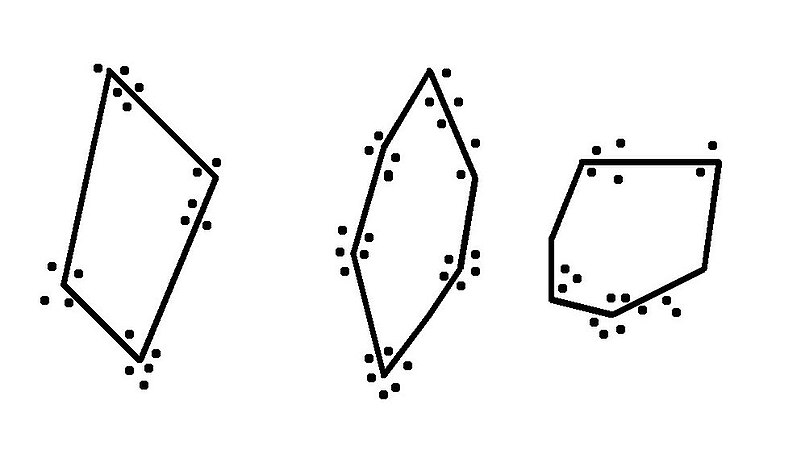
English: This diagram is depicting three territories from male of the subantarctic fur seal (Arctocephalus tropicalis). On this diagram, you can see that the confrontations (symbolized by black dot) happen on the borders of the territories. The black line correspond to the borders of the territories.This diagram drew his inspiration from the figure 10.6 a (examples of data in the Juan Fernandez Fur Seal) on the chapter 10 (life history and reproductive stratégies) from the book Marine Mammal Biology, an evolutionary approach. Edited by Hoelzel, A.R., Blackwell Science Ltd, 432p, 2002. This diagram has been made in accordance with the personal observations of his author : Nicolas Servera, (otarie_san@yahoo.fr). French Southern and Antarctic Lands. Crozet archipelago, Possession island, breeding colony «The Elephant seal's pool», summer campaign 2002-2003 (mission 40th).
Français : Ce schéma représente trois territoires établis par des mâles de l'otarie Arctocephalus tropicalis. Sur ce schéma, on peut voir que les conflits territoriaux (symbolisés par des points) ont lieu au niveau des frontières. Les lignes noires représentent les frontières de ces territoires. Ce schéma est inspiré de la figure 10.6 a (examples of data in the Juan Fernandez Fur Seal) du chapitre 10 (life history and reproductive stratégies) du livre Marine Mammal Biology, an evolutionary approach. Edited by Hoelzel, A.R., Blackwell Science Ltd, 432p, 2002. Ce schéma a été réalisé en tenant compte des observations personnelles de son auteur : Nicolas Servera, (otarie_san@yahoo.fr). Terre Australes et Antarctiques Françaises. Archipel Crozet, Ile de la Possession, colonie de reproduction dîte de « la Mare aux Eléphants », campagne d'été 2002-2003 (40ème mission). |
| Date | |
| Source | Own work |
| Author | Nicolas Servera (otarie_san@yahoo.fr) |
Licensing
[edit]
I, the copyright holder of this work, hereby publish it under the following licenses:

|
Permission is granted to copy, distribute and/or modify this document under the terms of the GNU Free Documentation License, Version 1.2 or any later version published by the Free Software Foundation; with no Invariant Sections, no Front-Cover Texts, and no Back-Cover Texts. A copy of the license is included in the section entitled GNU Free Documentation License. |
This file is licensed under the Creative Commons Attribution-Share Alike 3.0 Unported, 2.5 Generic, 2.0 Generic and 1.0 Generic license.
- You are free:
- to share – to copy, distribute and transmit the work
- to remix – to adapt the work
- Under the following conditions:
- attribution – You must give appropriate credit, provide a link to the license, and indicate if changes were made. You may do so in any reasonable manner, but not in any way that suggests the licensor endorses you or your use.
- share alike – If you remix, transform, or build upon the material, you must distribute your contributions under the same or compatible license as the original.
You may select the license of your choice.
File history
Click on a date/time to view the file as it appeared at that time.
| Date/Time | Thumbnail | Dimensions | User | Comment | |
|---|---|---|---|---|---|
| current | 20:35, 29 July 2008 | | 993 × 558 (43 KB) | Otarie san (talk | contribs) | {{Information |Description={{en|1=This diagram is depicting the layout of several territories from male of the subantarctic fur seal (Arctocephalus tropicalis). This diagram drew his inspiration from the figure 10.6 a (examples of data in the Juan Fernand |
You cannot overwrite this file.
File usage on Commons
There are no pages that use this file.
File usage on other wikis
The following other wikis use this file:
- Usage on fr.wikipedia.org
- Usage on pt.wikipedia.org