File:Arabian Peninsula (MODIS 2019-12-09).jpg
Jump to navigation
Jump to search

Size of this preview: 732 × 600 pixels. Other resolutions: 293 × 240 pixels | 586 × 480 pixels | 937 × 768 pixels | 1,250 × 1,024 pixels | 2,499 × 2,048 pixels | 7,960 × 6,524 pixels.
Original file (7,960 × 6,524 pixels, file size: 10.2 MB, MIME type: image/jpeg)
Captions
Captions
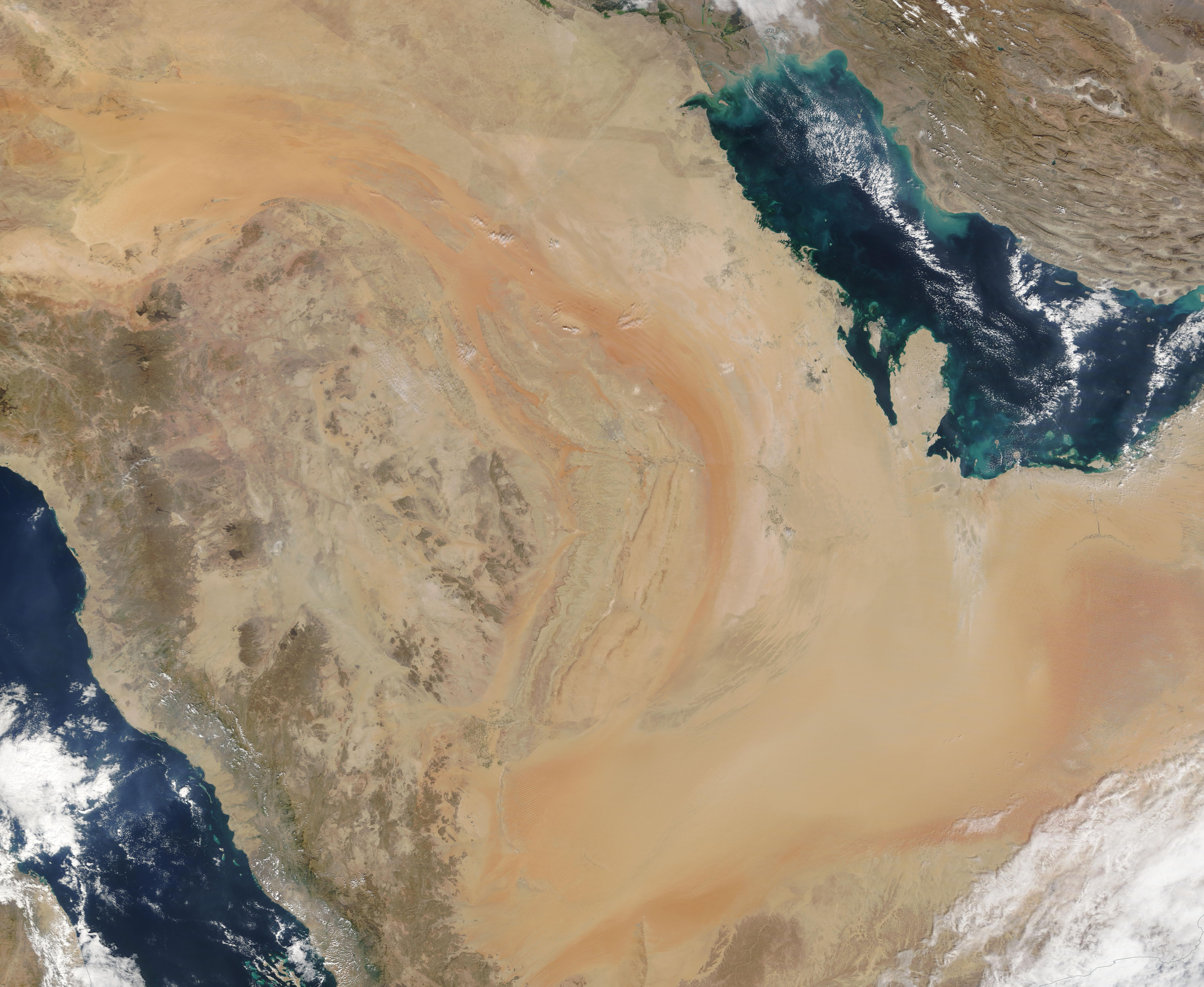
The Moderate Resolution Imaging Spectroradiometer (MODIS) on board NASA's Terra satellite captured a stunning true-color image of the Arabian Peninsula on December 5, 2019.
Summary
[edit].jpg&action=edit§ion=1)
| Description |
English: The Moderate Resolution Imaging Spectroradiometer (MODIS) on board NASA's Terra satellite captured a stunning true-color image of the Arabian Peninsula on December 5, 2019.
The Arabian Peninsula has coastlines on the Red Sea (west and southwest), the Gulf of Aden (south), the Arabian Sea (south and southeast), and the Gulf of Oman and the Persian Gulf on the east. While Saudi Arabia occupies the bulk of the Arabian Peninsula, six other countries share part of the land, primarily along the coasts. Starting in the northeast and moving clockwise around the Peninsula they are: Kuwait, Bahrain, Qatar, United Arab Emirates, Oman, and Yemen. One of the most striking features of this region is the warm orange- and peach-colored sands that fill the sprawling Empty Quarter—or Rub’ al Khali. Roughly the size of France, the Empty Quarter covers an area roughly the size of France on the southern end of the Peninsula. It holds about half as much sand as the entire Sahara Desert, including long fields of linear sand dunes. Much of the land in this region actually lies at an elevation below sea level, but near the Yemen border, dunes can reach an altitude of 1,200 meters (3,900 feet) above sea level. |
||
| Date | Taken on 5 December 2019 | ||
| Source |
Arabian Peninsula (direct link)
|
||
| Author | MODIS Land Rapid Response Team, NASA GSFC |
| This media is a product of the Terra mission Credit and attribution belongs to the mission team, if not already specified in the "author" row |
Licensing
[edit].jpg&action=edit§ion=2)
| This file is in the public domain in the United States because it was solely created by NASA. NASA copyright policy states that "NASA material is not protected by copyright unless noted". (See Template:PD-USGov, NASA copyright policy page or JPL Image Use Policy.) | ||
 |
Warnings:
|
File history
Click on a date/time to view the file as it appeared at that time.
| Date/Time | Thumbnail | Dimensions | User | Comment | |
|---|---|---|---|---|---|
| current | 02:44, 17 February 2024 | | 7,960 × 6,524 (10.2 MB) | OptimusPrimeBot (talk | contribs) | #Spacemedia - Upload of http://modis.gsfc.nasa.gov/gallery/images/image12092019_250m.jpg via Commons:Spacemedia |
You cannot overwrite this file.
File usage on Commons
There are no pages that use this file.
.jpg&oldid=909380951)