File:Arab world map 1154.png
Jump to navigation
Jump to search
No higher resolution available.
Arab_world_map_1154.png (342 × 336 pixels, file size: 76 KB, MIME type: image/png)
Captions
Captions
Add a one-line explanation of what this file represents
Summary
[edit]
| Description |
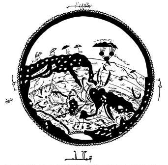
English: Copy form 1500 of a map drawn by the Arab geographer Idrisi in 1154. South on top. Africa is shown in the tradition of Ptolemy: The Nile flows out of two lakes, probably representing Lake Victoria and Lake Edward, and unites in a third lake, probably representing Lake Albert.
Deutsch: Weltkarte des arabischen Geografen Idrisi (Original 1154, Kopie um 1500). Süden ist oben. Darstellung Afrikas in der Tradition Claudius Ptolemäus: Der Nil entfließt zwei großen Seen, wohl Viktoriasee und Eduardsee entsprechend. Der See, in dem sie sich vereinigen, entpricht wohl dem Albertsee. |
| Date | |
| Source | Andreas Speer, Lydia Wegener: "Wissen über Grenzen: Arabisches wissen und lateinisches Mittelalter", 2006, Walter de Gruyter |
| Author | Idrisi (Arab geographer), shot & upload Ulamm (talk) 11:48, 1 November 2008 (UTC) |
Licensing
[edit]
|
This work is in the public domain in its country of origin and other countries and areas where the copyright term is the author's life plus 100 years or fewer. | |
| This file has been identified as being free of known restrictions under copyright law, including all related and neighboring rights. | |
File history
Click on a date/time to view the file as it appeared at that time.
| Date/Time | Thumbnail | Dimensions | User | Comment | |
|---|---|---|---|---|---|
| current | 11:48, 1 November 2008 | | 342 × 336 (76 KB) | Ulamm (talk | contribs) | {{Information |Description={{en|1=Map drawn by the Arab geographer Idrisi, south on top. Africa is shown in the tradition of Ptolemy: The Nile flows out of two lakes, probably representing Lake Victoria and Lake Albert, and unites in a third lake, probabl |
You cannot overwrite this file.
File usage on Commons
The following page uses this file: