File:April 27, 2011 severe weather warnings.JPG
Jump to navigation
Jump to search

Size of this preview: 800 × 539 pixels. Other resolutions: 320 × 216 pixels | 640 × 431 pixels | 1,070 × 721 pixels.
Original file (1,070 × 721 pixels, file size: 260 KB, MIME type: image/jpeg)
Captions
Captions
Add a one-line explanation of what this file represents
Summary
[edit]
| Description |
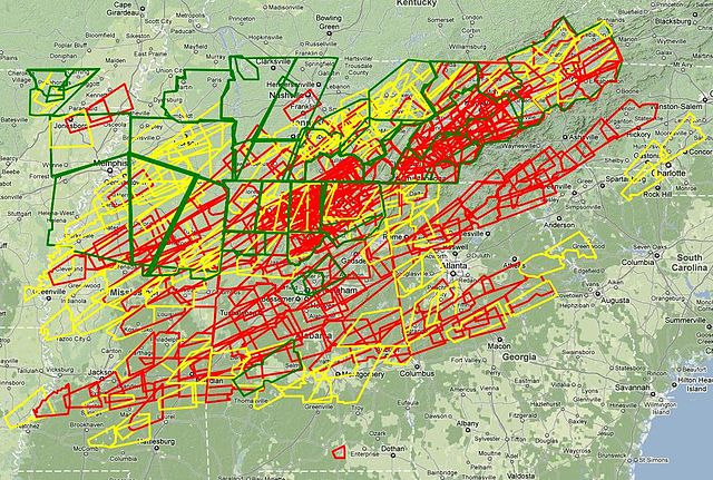
English: Composite map of all Tornado (red), Severe Thunderstorm (yellow) and Flood warnings (green) issued throughout the major tornado outbreak on April 27, 2011. |
| Date | |
| Source | https://www.webcitation.org/5yMJzlAwx |
| Author | National Weather Service in Kansas City/Pleasant Hill, Missouri |
| Permission (Reusing this file) |
Public Domain |
The most red is alabama
Licensing
[edit]
This image is in the public domain because it contains materials that originally came from the U.S. National Oceanic and Atmospheric Administration, taken or made as part of an employee's official duties.
|
File history
Click on a date/time to view the file as it appeared at that time.
| Date/Time | Thumbnail | Dimensions | User | Comment | |
|---|---|---|---|---|---|
| current | 15:57, 1 May 2011 | | 1,070 × 721 (260 KB) | Cyclonebiskit (talk | contribs) | {{Information |Description ={{en|1=Composite map of all Tornado (red), Severe Thunderstorm (yellow) and Flood warnings (green) issued throughout the major tornado outbreak on April 27, 2011. }} |Source =http://www.webcitation.org/5yMJzlAwx |Aut |
You cannot overwrite this file.
File usage on Commons
There are no pages that use this file.
File usage on other wikis
The following other wikis use this file:
- Usage on el.wikipedia.org
- Usage on en.wikipedia.org
- Usage on fr.wikipedia.org
- Usage on no.wikipedia.org
- Usage on pt.wikipedia.org