File:Approaching St Thomas' church from The Street - geograph.org.uk - 889197.jpg
Jump to navigation
Jump to search

Size of this preview: 450 × 600 pixels. Other resolutions: 180 × 240 pixels | 480 × 640 pixels.
Original file (480 × 640 pixels, file size: 131 KB, MIME type: image/jpeg)
Captions
Captions
Add a one-line explanation of what this file represents
Summary
[edit]
| Description |
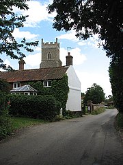
English: Approaching St Thomas' church from The Street. St Thomas' church > 889241 - 889282 is located beside The Street > 889136 - the main thoroughfare through the eastern part of Foxley; in the 1990s the village was split into two sections by the construction of the A1067 (Norwich Road) > 889166. The church has a late 13th century chancel; the box pews and two-decker pulpit > 889271 date from the 17th century. Only four painted panels remain on the C15 rood screen > 889250 and these can easily be overlooked, because they are on the doors which are usually being kept open (with the panels facing east). The panels depict the Latin Doctors of the Catholic Church: St Augustine, St Gregory, St Jerome and St Ambrose; the small kneeling figures depict the donors > 889263 - 889265. The porch > 889229 was painted in the 19th century and the west gallery dates from the same time. The font is C14 with a C17 cover > 889286. The church is kept locked but a key is available on request from nearby. For more information see: http://www.norfolkchurches.co.uk/foxley/foxley.htm |
| Date | |
| Source | From geograph.org.uk |
| Author | Evelyn Simak |
| Attribution (required by the license) | Evelyn Simak / Approaching St Thomas' church from The Street / |
_-_geograph.org.uk_-_889166.jpg)
| Camera location | | View this and other nearby images on: OpenStreetMap |
|---|
_heading:90.00&language=en)
| Object location | | View this and other nearby images on: OpenStreetMap |
|---|
_heading:90.00&language=en)
Licensing
[edit]

|
This image was taken from the Geograph project collection. See this photograph's page on the Geograph website for the photographer's contact details. The copyright on this image is owned by Evelyn Simak and is licensed for reuse under the Creative Commons Attribution-ShareAlike 2.0 license.
|
This file is licensed under the Creative Commons Attribution-Share Alike 2.0 Generic license.
Attribution: Evelyn Simak
- You are free:
- to share – to copy, distribute and transmit the work
- to remix – to adapt the work
- Under the following conditions:
- attribution – You must give appropriate credit, provide a link to the license, and indicate if changes were made. You may do so in any reasonable manner, but not in any way that suggests the licensor endorses you or your use.
- share alike – If you remix, transform, or build upon the material, you must distribute your contributions under the same or compatible license as the original.
File history
Click on a date/time to view the file as it appeared at that time.
| Date/Time | Thumbnail | Dimensions | User | Comment | |
|---|---|---|---|---|---|
| current | 11:43, 21 February 2011 | | 480 × 640 (131 KB) | GeographBot (talk | contribs) | == {{int:filedesc}} == {{Information |description={{en|1=Approaching St Thomas' church from The Street St Thomas' church > http://www.geograph.org.uk/photo/889241 - http://www.geograph.org.uk/photo/889282 is located beside The Street > http://www.geograph |
You cannot overwrite this file.
File usage on Commons
There are no pages that use this file.