File:Appalachian Highlands.jpg
Jump to navigation
Jump to search

Size of this preview: 800 × 451 pixels. Other resolutions: 320 × 180 pixels | 640 × 361 pixels | 1,024 × 577 pixels | 1,547 × 872 pixels.
Original file (1,547 × 872 pixels, file size: 205 KB, MIME type: image/jpeg)
Captions
Captions
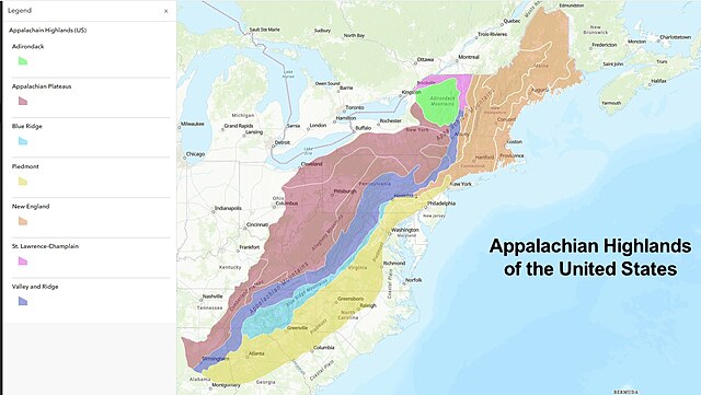
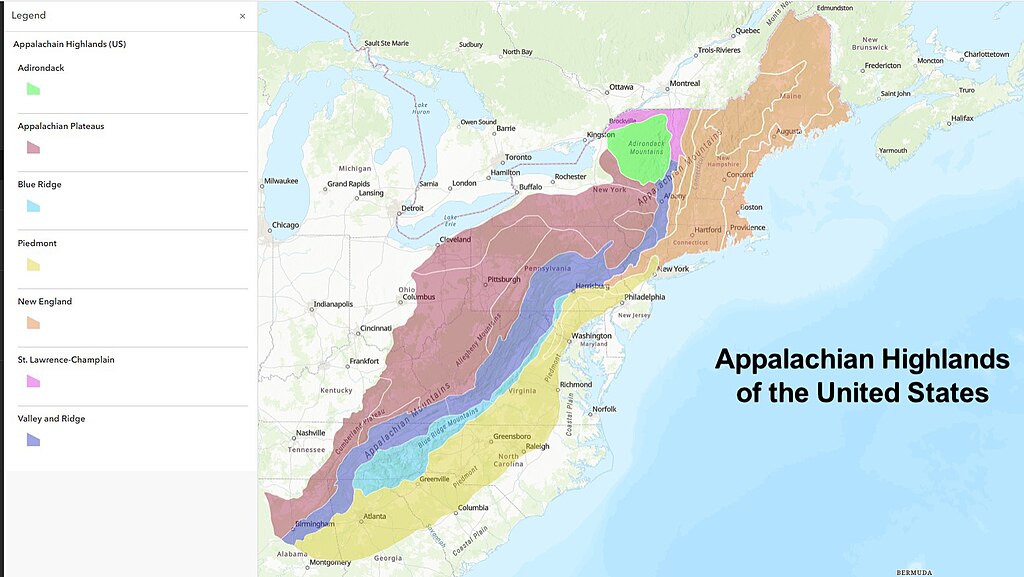
Appalachian Highlands Physiographic Division of the United States.
Summary
[edit]
| Description |
English: This map shows the seven provinces that comprise the Appalachian Highlands Physiographic division of the United States. The Appalachian Mountains are comprised of both this area and the Appalachian Uplands category in Canada. |
| Date | |
| Source | Own work |
| Author | Deanrah |
Licensing
[edit]
I, the copyright holder of this work, hereby publish it under the following license:
This file is licensed under the Creative Commons Attribution-Share Alike 4.0 International license.
- You are free:
- to share – to copy, distribute and transmit the work
- to remix – to adapt the work
- Under the following conditions:
- attribution – You must give appropriate credit, provide a link to the license, and indicate if changes were made. You may do so in any reasonable manner, but not in any way that suggests the licensor endorses you or your use.
- share alike – If you remix, transform, or build upon the material, you must distribute your contributions under the same or compatible license as the original.
File history
Click on a date/time to view the file as it appeared at that time.
| Date/Time | Thumbnail | Dimensions | User | Comment | |
|---|---|---|---|---|---|
| current | 19:03, 2 September 2023 | | 1,547 × 872 (205 KB) | Deanrah (talk | contribs) | Added Lines showing sections of New England |
| 01:19, 30 August 2023 |  | 1,152 × 810 (139 KB) | Deanrah (talk | contribs) | Uploaded own work with UploadWizard |
You cannot overwrite this file.
File usage on Commons
The following page uses this file:
File usage on other wikis
The following other wikis use this file:
- Usage on en.wikipedia.org