File:Apollo 11- 'A Stark Beauty All Its Own' (6962456839).jpg
Original file (1,000 × 1,000 pixels, file size: 591 KB, MIME type: image/jpeg)
Captions
Captions
Summary
[edit].jpg&action=edit§ion=1)
| Description |
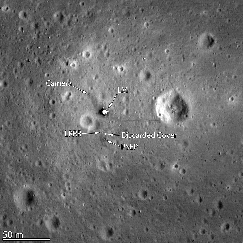
This image of the Apollo 11 landing site captured from just 24 km (15 miles) above the surface provides LRO's best look yet at humanity’s first venture to another world. When Neil Armstrong took his famous first steps onto the lunar surface, he kicked around the soil. “Yes, the surface is fine and powdery.” Gazing at the flat horizon, he took in the view. “Isn’t that something! Magnificent sight out here.” After collecting a contingency sample Neil looked around and observed, "it has a stark beauty all its own. It's like much of the high desert of the United States. It's different, but it's very pretty out here." A few minutes later Buzz Aldrin descended the ladder and joined Neil on the surface of the Moon! You can see the remnants of their first steps as dark regions around the Lunar Module (LM) and in dark tracks that lead to the scientific experiments the astronauts set up on the surface. The Passive Seismic Experiment Package (PSEP) provided the first lunar seismic data, returning data for three weeks after the astronauts left, and the Laser Ranging RetroReflector (LRRR) allows precise measurements to be collected to this day. You can even spot the discarded cover of the LRRR. Another trail leads toward Little West crater around 50 meters (164 feet) to the east of the LM. This was an unplanned excursion near the end of the two and a half hours spent on the surface. Armstrong ran over to get a look inside the crater, and this was the farthest either astronaut ventured from the landing site. Compared to Apollo 12 and 14, which allowed for more time on the surface, and Apollo 15, 16, and 17, which had the benefit of a Lunar Roving Vehicle, Armstrong and Aldrin's surface activities were quite restricted. Their tracks cover less area than a typical city block! Not only was the landscape a place of "stark beauty", but also the source of rocks that revealed the Moon’s fiery past for the first time. The samples showed that the Apollo 11 landing site in Mare Tranquillitatis was once the site of volcanic activity, and the flat surface that afforded such an incredible vista was due to broad, thin flows of lava that flooded the region. NASA Goddard Space Flight Center enables NASA’s mission through four scientific endeavors: Earth Science, Heliophysics, Solar System Exploration, and Astrophysics. Goddard plays a leading role in NASA’s accomplishments by contributing compelling scientific knowledge to advance the Agency’s mission. Follow us on Twitter Like us on Facebook Find us on Instagram |
| Date | |
| Source | Apollo 11: 'A Stark Beauty All Its Own' |
| Author | NASA Goddard Space Flight Center from Greenbelt, MD, USA |
Licensing
[edit].jpg&action=edit§ion=2)
- You are free:
- to share – to copy, distribute and transmit the work
- to remix – to adapt the work
- Under the following conditions:
- attribution – You must give appropriate credit, provide a link to the license, and indicate if changes were made. You may do so in any reasonable manner, but not in any way that suggests the licensor endorses you or your use.
| This image was originally posted to Flickr by NASA Goddard Photo and Video at https://flickr.com/photos/24662369@N07/6962456839. It was reviewed on 17 September 2016 by FlickreviewR and was confirmed to be licensed under the terms of the cc-by-2.0. |
| This file is in the public domain in the United States because it was solely created by NASA. NASA copyright policy states that "NASA material is not protected by copyright unless noted". (See Template:PD-USGov, NASA copyright policy page or JPL Image Use Policy.) | ||
 |
Warnings:
|
File history
Click on a date/time to view the file as it appeared at that time.
| Date/Time | Thumbnail | Dimensions | User | Comment | |
|---|---|---|---|---|---|
| current | 21:51, 17 September 2016 | | 1,000 × 1,000 (591 KB) | Vanished Account Byeznhpyxeuztibuo (talk | contribs) | Transferred from Flickr via Flickr2Commons |
You cannot overwrite this file.
File usage on Commons
There are no pages that use this file.
File usage on other wikis
The following other wikis use this file:
- Usage on it.wikipedia.org
.jpg&oldid=862544803)