File:Antoine Augustin Calmet, Karte von der Lage des Paradieses (FL200036759 2368455).jpg
Jump to navigation
Jump to search

Size of this preview: 456 × 599 pixels. Other resolutions: 183 × 240 pixels | 365 × 480 pixels | 585 × 768 pixels | 780 × 1,024 pixels | 2,260 × 2,968 pixels.
Original file (2,260 × 2,968 pixels, file size: 9.78 MB, MIME type: image/jpeg)
Captions
Captions
Add a one-line explanation of what this file represents
Summary
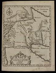
[edit]| Antoine Augustin Calmet: Karte von der Lage des Paradieses
( |
||||||||||||||||||||||||
|---|---|---|---|---|---|---|---|---|---|---|---|---|---|---|---|---|---|---|---|---|---|---|---|---|
| Artist |
| |||||||||||||||||||||||
| Contributors | Gloeckner, Hieronymus George Siegert, David Pueschel, Johann Joachim | |||||||||||||||||||||||
| Title |
Karte von der Lage des Paradieses |
|||||||||||||||||||||||
| Publisher |
David Siegert |
|||||||||||||||||||||||
| Description |
Karte von der Lage des Paradieses. nach dem Lehrbegriffe des Hern Bischof Hvetius Pueschel sc. Lipsiae. |
|||||||||||||||||||||||
| Language | German | |||||||||||||||||||||||
| Publication date | 1753 | |||||||||||||||||||||||
| Dimensions | height: 228 mm (8.97 in); width: 168 mm (6.61 in) | |||||||||||||||||||||||
| Collection |
|
|||||||||||||||||||||||
| Current location |
|
|||||||||||||||||||||||
| Place of publication | Legnica | |||||||||||||||||||||||
| search Merhav catalog | Legnica | |||||||||||||||||||||||
| Notes | Copperplate; From: Calmet, Augustin Antoine. Biblische Woerterbuch... heraudgegeben von Hieronymus George Gloeckner, Liegnitz, D. Siegert, 1753. Vol.III, after p. 390. 22 V 1100 Vol. III. | |||||||||||||||||||||||
| IE PID | IE200036757 | |||||||||||||||||||||||
| Rosetta filename | FL200036759 | |||||||||||||||||||||||
| NNL item ID (P3959) | 990023684550205171 | |||||||||||||||||||||||
| search Merhav catalog | German, Antoine Augustin Calmet | |||||||||||||||||||||||
| search Merhav catalog | David Siegert | |||||||||||||||||||||||
| Source/Photographer |
|
|||||||||||||||||||||||
| Other versions | ||||||||||||||||||||||||
| Jpg / Tif version |
|
|||||||||||||||||||||||
.jpg)

.jpg)

.jpg&action=edit§ion=1)
Licensing
[edit].jpg&action=edit§ion=2)
The copyright situation of this work is theoretically uncertain, because in the country of origin copyright lasts 70 years after the death of the author, and the date of the author's death is unknown. However, the date of creation of the work was over 120 years ago, and it is thus a reasonable assumption that the copyright has expired (see here for the community discussion). Do not use this template if the date of death of the author is known.
| |
| This file has been identified as being free of known restrictions under copyright law, including all related and neighboring rights. | |
File history
Click on a date/time to view the file as it appeared at that time.
| Date/Time | Thumbnail | Dimensions | User | Comment | |
|---|---|---|---|---|---|
| current | 08:32, 28 July 2023 | | 2,260 × 2,968 (9.78 MB) | Geagea (talk | contribs) | pattypan 22.03 |
You cannot overwrite this file.
File usage on Commons
The following page uses this file:
.jpg&oldid=799278509)