File:Antioch of Pisidia 2876.jpg
Jump to navigation
Jump to search
Size of this preview: 800 × 533 pixels. Other resolutions: 320 × 213 pixels | 640 × 426 pixels | 1,024 × 682 pixels | 1,280 × 852 pixels | 1,600 × 1,065 pixels.
Original file (1,600 × 1,065 pixels, file size: 591 KB, MIME type: image/jpeg)
Captions
Captions
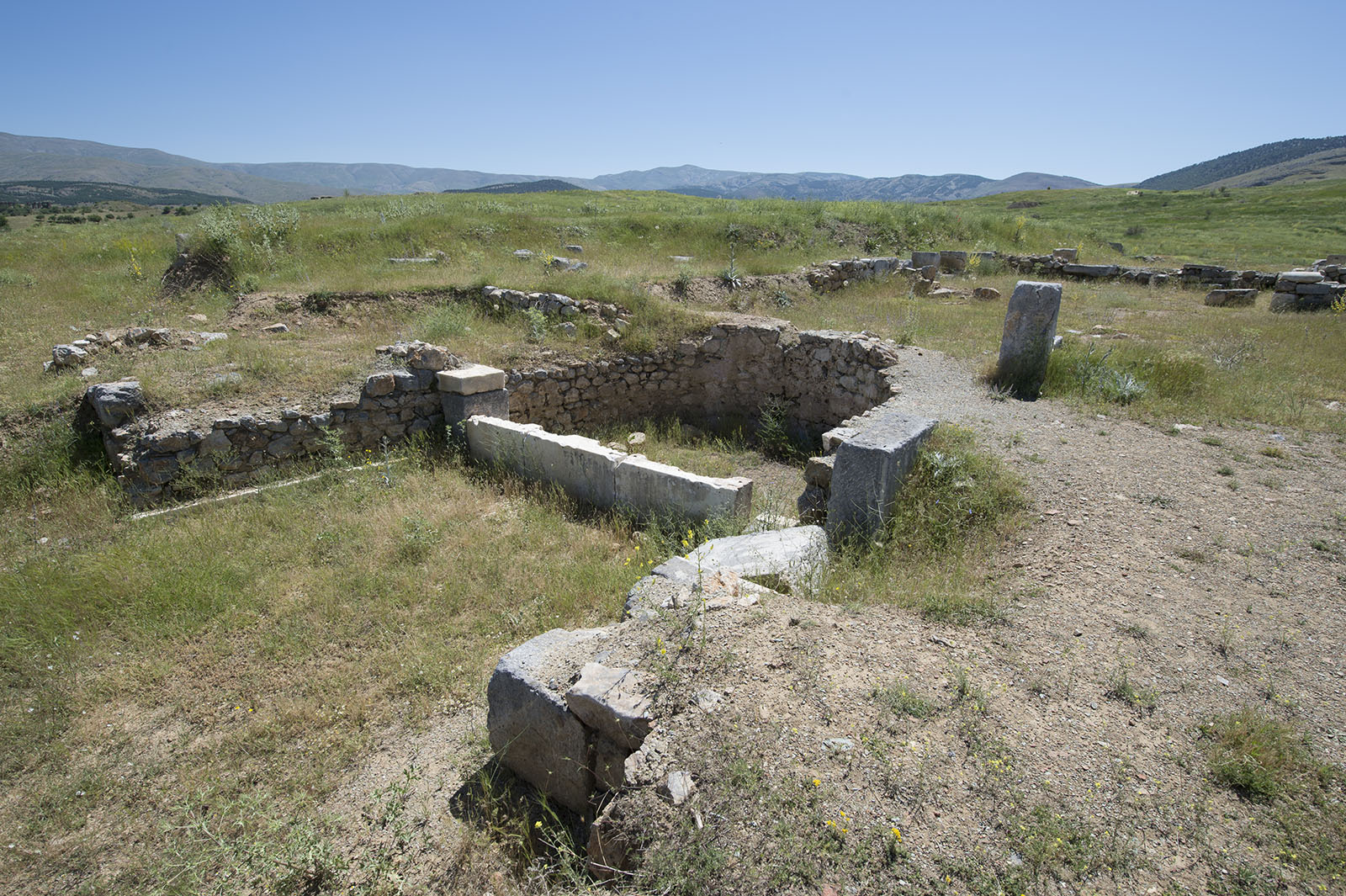
Antioch of Pisidia Fountain at St. Paul's
Summary
[edit]
| Description |
English: St. Paul’s Church (Great Basilica). The building reflects all the elements of basilical plan and consists of three naves and a semicircular apse. The exterior surface of the apse is encircled with a hexagonal wall. The apse has a diameter of 10,8 m and a depth of 9,2 m. The central nave is separated from the narrow naves on the sides by two rows of columns each having 13 columns and these columns test on hexagonal bases. The 27 x 13 m narthex (entrance) on the west of the building, which measures 70 x 27 m, lies in the east west direction and leans on the city walls. The ground of the central nave is composed of red, yellow, white and black tesserae and is covered with a mosaic decorated with geometric and floral motifs. The name of Archbishop Optimus, represented Antiocheia in the Council of Constantinople in 381 AD and one of the founders of Orthodoxy takes place in an inscription on the mosaic in front of the apse. This name forms a basis for dating the building construction to the late 4th century AD. This date is the beginning date for the monumental churches in Anatolia. The Great Basilica of Antiocheia is one of the two earliest example of Early Christian churches. The church visible today is the 5th – 6th century AD church, which was a restored version from the late 4th century AD and placed on the 1st floor of the church of Optimus. St. Paul, regarded as the most famous and efficient missionary of Early Christianity together with St. Pierre, had three visits to Antiocheai between the years 46-62 AD and preached in the synagogue under the foundations of the current church. He announced Christianity to the world from here. In his preaching in the synagogue on the Sabbath he read texts from Holy Law and writings of the prophet. This is considered as St. Paul’s first preaching as a missionary.
On the picture: An early-Byzantine fountain, beside the basilica. Correspondent: J.M.Criel, Antwerpen. Sources: ‘Pisidian Antioch’ – Ünal Demirer, archaeologist. (Ankara, 1997) . |
| Date | |
| Source | Own work |
| Author | Dosseman |
| Camera location | | View this and other nearby images on: OpenStreetMap |
|---|
Licensing
[edit]
I, the copyright holder of this work, hereby publish it under the following license:
This file is licensed under the Creative Commons Attribution-Share Alike 4.0 International license.
- You are free:
- to share – to copy, distribute and transmit the work
- to remix – to adapt the work
- Under the following conditions:
- attribution – You must give appropriate credit, provide a link to the license, and indicate if changes were made. You may do so in any reasonable manner, but not in any way that suggests the licensor endorses you or your use.
- share alike – If you remix, transform, or build upon the material, you must distribute your contributions under the same or compatible license as the original.
File history
Click on a date/time to view the file as it appeared at that time.
| Date/Time | Thumbnail | Dimensions | User | Comment | |
|---|---|---|---|---|---|
| current | 20:39, 6 March 2019 | | 1,600 × 1,065 (591 KB) | Dosseman (talk | contribs) | User created page with UploadWizard |
You cannot overwrite this file.
File usage on Commons
There are no pages that use this file.
File usage on other wikis
The following other wikis use this file:
- Usage on en.wikipedia.org
- Usage on sw.wikipedia.org