File:Antioch in Pisidia Augustus Temple 2937.jpg
Jump to navigation
Jump to search

Size of this preview: 800 × 533 pixels. Other resolutions: 320 × 213 pixels | 640 × 426 pixels | 1,024 × 682 pixels | 1,280 × 852 pixels | 1,600 × 1,065 pixels.
Original file (1,600 × 1,065 pixels, file size: 465 KB, MIME type: image/jpeg)
Captions
Captions
Antioch in Pisidia Augustus Temple
Summary
[edit]
| Description |
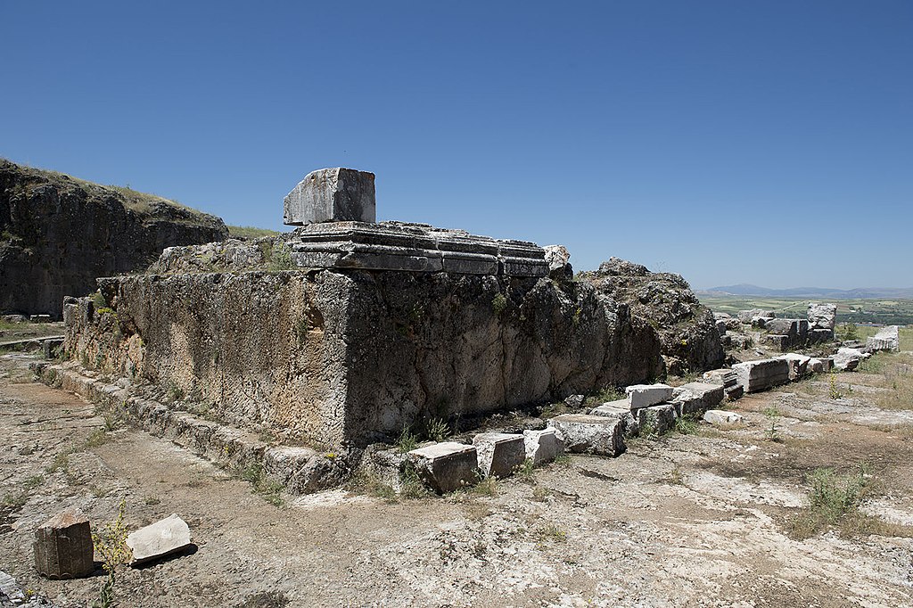
English: A notice read: "Augustus Temple. The temple is built on the sacred area that is located at the highest point of the city after Emperor Augustus and dedicated to him. The foundation of the building is carved from the natural rock. The temple rests on a 2,5 m [high] podium and is accessed from the west façade through a flight of stairs with twelve steps. The podium of the temple measures 26 x 15 meter. The construction is a prostylos with 4 columns in front and Corinthian capitals are used. The antae of the pronaos are not in the form of a wall and there is a column at each side. The pronaos is 7,7 m long. The cella measures 12 x 10,10 m and is nearly a square in form. The thickness of the cella walls changes between 1,1 and 0,7 m. The cella wall is encircled by a frieze of scrolled leafs. A garland frize measuring 0,5 x 10 m, which is supported with burcrania, lies over the three-fascia architrave resting on the columns. In the pediment, the geison is plain; the sigma is decorated with palmette motifs and in the central part, there is a window surrounded with egg and bead rows (epiphany). Between the scrolls of the apex acroterium Nike; on the sides acanthus leaves are depicted in high relief. Behind the temple there is a two-storey gallery formed by carving the natural rock in a semi-circular shape. Doric columns are used in the downstairs while Ionic columns are used in the upper floor. In front of the temple, an area named after the Emperor and measuring 63 x 85 is created. The foundations of the porticos in the north and south of the area, approximately 5 m wide can be partially traced. The finds from the inscriptions and decorative works of the structure indicate that the construction activities continued in the period spanning the time of Roman Emperor Tiberius to the time of Claudius. "
On the picture: The podium and some other remains of the Augustus Temple. This building, the large esplanade in front of it, and the gallery behind it formed together a monumental imperial sanctuary called ‘Augusteum’. A notice at the gate gives: "Antiocheia is on a hill approximately 1236 m high and lies 1 km north of Yalvaç County of Isparta Province. The city is surrounded my the Sultan Mountains to the east, Karakuş Mountain to the north, Kızıldağ Mountain to the southeast, Kirisli Mountain and northern shore of Eğirdir Lake to the southwest. The acropolis of the citadel, which is surrounded by city walls, has an area of 47 hectares. The antique city was founded my Antiochus I from the Seleucid dynasty, between 281 BC – 261 BC and was called “Antiocheia”. Emperor Augustus, who established the first an greatest military colony in Pisidia, honoured the city with the title of Caesareia in 25 BC. The city became the capital of the region and a rich metropolis during the Roman Period. In the Early Empire Period the city was reconstructed on a new systematic plan, and many religious and secular buildings were built. The currently known buildings with the grid plan are the Augustan Temple, Theatre, Roman Bath, St. Paul’s Church, Central Church, Northern Church, Tiberius Square and Nymphaeum, besides these, Decumanus Maximus, Cardo Maximus, Western Gate and Propylon are also excavated at the archaeological site. St. Paul, one of the twelve apostles of Jesus Christ who played an essential role in the spreading of Christianity with his political identity, made three journeys from Jerusalem to Antiocheia, the capital of Pisidia. He lived there as a tent maker for two years. He taught Christianity by addressing the people of different faiths, and he preached Christianity from Antiocheia. All these factors further increased the importance of Antiocheia." |
| Date | |
| Source | Own work |
| Author | Dosseman |
| Camera location | | View this and other nearby images on: OpenStreetMap |
|---|
Many pictures were identified with the help of J.M.Criel, Antwerpen, whop himself mentioned as sources: ‘Pisidian Antioch’ – Ünal Demirer, archaeologist. (Ankara, 1997) & Personal visits (1994 – 2003).
Licensing
[edit]
I, the copyright holder of this work, hereby publish it under the following license:
This file is licensed under the Creative Commons Attribution-Share Alike 4.0 International license.
- You are free:
- to share – to copy, distribute and transmit the work
- to remix – to adapt the work
- Under the following conditions:
- attribution – You must give appropriate credit, provide a link to the license, and indicate if changes were made. You may do so in any reasonable manner, but not in any way that suggests the licensor endorses you or your use.
- share alike – If you remix, transform, or build upon the material, you must distribute your contributions under the same or compatible license as the original.
File history
Click on a date/time to view the file as it appeared at that time.
| Date/Time | Thumbnail | Dimensions | User | Comment | |
|---|---|---|---|---|---|
| current | 17:15, 25 June 2020 | | 1,600 × 1,065 (465 KB) | Dosseman (talk | contribs) | Uploaded own work with UploadWizard |
You cannot overwrite this file.
File usage on Commons
There are no pages that use this file.