File:Antigo Convento de Nossa Senhora dos Anjos - Torres Vedras - Portugal (52005865226).jpg

Original file (2,048 × 1,364 pixels, file size: 2.39 MB, MIME type: image/jpeg)
Captions
Captions
Summary
[edit].jpg&action=edit§ion=1)
| Description |
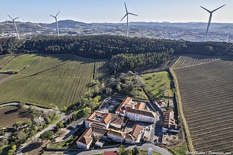
O Convento dos Religiosos Arrábidos, conhecido como Convento do Barro, foi fundado em 1570, pela Infanta D. Maria, filha do Rei D. Manuel, para acolher monges franciscanos. Em 1834, o convento foi extinto e expropriado, tendo reaberto em 1860. Com a implantação da República em Portugal foi definitivamente encerrado enquanto convento, passando a denominar-se Asilo Elias Garcia. O ato inaugural foi presidido por Teófilo Braga. No espaço exterior existe um monumento de devoção à Excelsa Mãe de Deus, edificado em 1908, por ocasião das comemorações dos 50 anos da aparição da Virgem Imaculada em Lourdes. Nas imediações do convento localiza-se a capela de São José, erigida no século XVI. No início do século XX, o Asilo assumiu um papel importante no combate ao flagelo da tuberculose, tendo sido confiado à Assistência Nacional aos Tuberculosos, na segunda metade do século. Em 1956, é nomeado para diretor clínico do sanatório o Dr. José Maria Antunes Júnior. A partir de 1956, os serviços gerais do Asilo passam a ser assegurados por freiras, possibilitando o internamento dos doentes. Esta situação manteve-se até 1992, ano em que as religiosas deixaram de prestar serviço hospitalar. Em 1993, o Sanatório do Barro passou a ser designado de Hospital Dr. José Maria Antunes Júnior, alargando a sua ação terapêutica ao tratamento de doenças da área da pneumologia. <a href="http://cm-tvedras.pt/turismo/visitar/patrimonio-religioso/" rel="noreferrer nofollow">cm-tvedras.pt/turismo/visitar/patrimonio-religioso/</a> |
| Date | |
| Source | Antigo Convento de Nossa Senhora dos Anjos - Torres Vedras - Portugal 🇵🇹 |
| Author | Vitor Oliveira from Torres Vedras, PORTUGAL |
| Camera location | | View this and other nearby images on: OpenStreetMap |
|---|
.jpg¶ms=039.065705_N_-009.262120_E_globe:Earth_type:camera_source:Flickr_&language=en)
Licensing
[edit].jpg&action=edit§ion=2)
- You are free:
- to share – to copy, distribute and transmit the work
- to remix – to adapt the work
- Under the following conditions:
- attribution – You must give appropriate credit, provide a link to the license, and indicate if changes were made. You may do so in any reasonable manner, but not in any way that suggests the licensor endorses you or your use.
- share alike – If you remix, transform, or build upon the material, you must distribute your contributions under the same or compatible license as the original.
| This image was originally posted to Flickr by Portuguese_eyes at https://flickr.com/photos/21446942@N00/52005865226. It was reviewed on 20 April 2022 by FlickreviewR 2 and was confirmed to be licensed under the terms of the cc-by-sa-2.0. |
File history
Click on a date/time to view the file as it appeared at that time.
| Date/Time | Thumbnail | Dimensions | User | Comment | |
|---|---|---|---|---|---|
| current | 20:04, 20 April 2022 | | 2,048 × 1,364 (2.39 MB) | Tm (talk | contribs) | Transferred from Flickr via #flickr2commons |
You cannot overwrite this file.
File usage on Commons
There are no pages that use this file.
File usage on other wikis
The following other wikis use this file:
- Usage on es.wikipedia.org
.jpg&oldid=799150332)