File:Antietam. LOC 99447379.jpg
Jump to navigation
Jump to search
Size of this preview: 685 × 600 pixels. Other resolutions: 274 × 240 pixels | 548 × 480 pixels | 877 × 768 pixels | 1,169 × 1,024 pixels | 2,339 × 2,048 pixels | 6,759 × 5,919 pixels.
Original file (6,759 × 5,919 pixels, file size: 10.38 MB, MIME type: image/jpeg)
Captions
Captions
Add a one-line explanation of what this file represents
Summary
[edit]| Description |
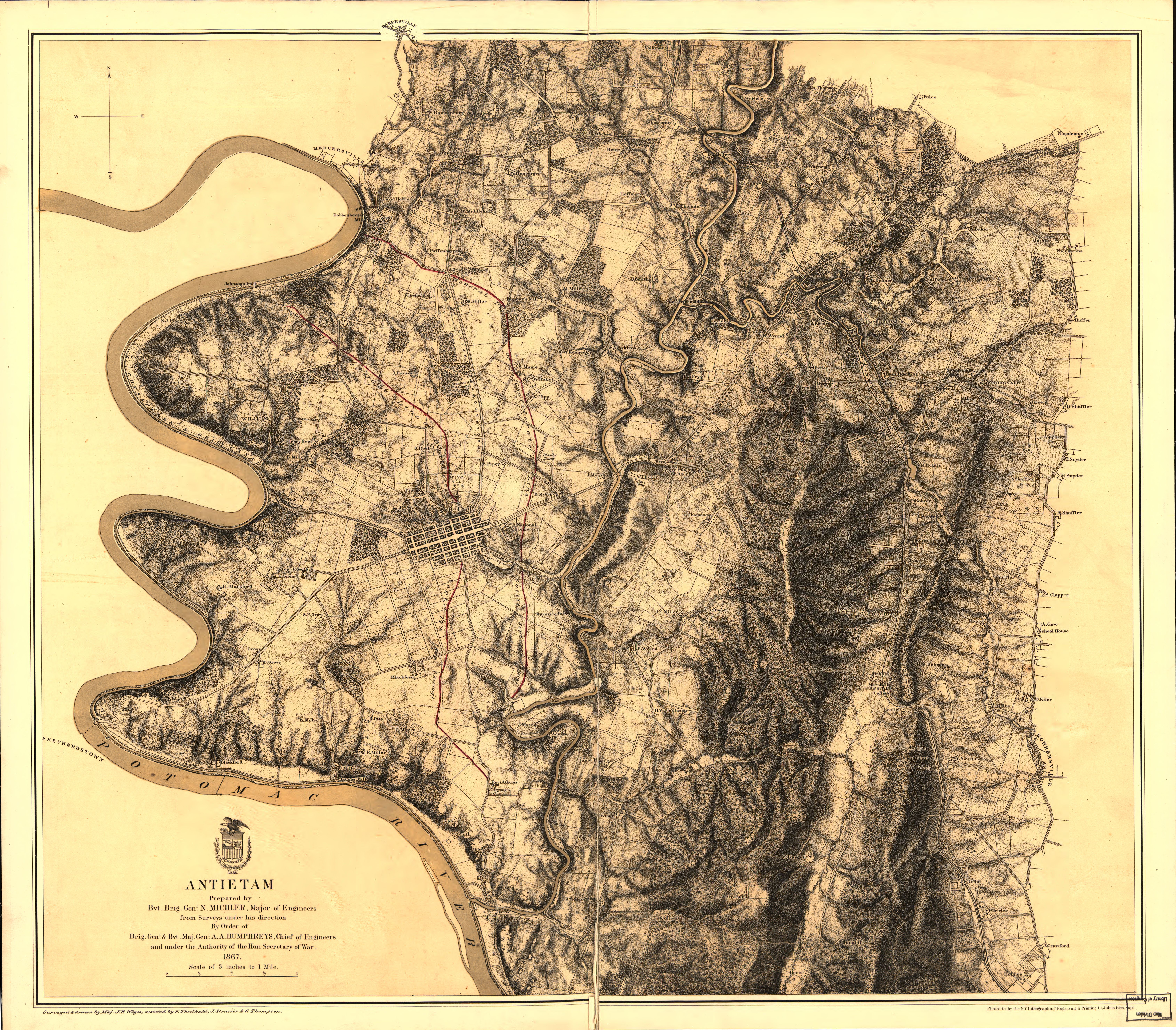
English: Scale 1:21,120. LC Civil War Maps (2nd ed.), 245.8 "General direction of Confederate line of battle, Sept. 16th 1862" and "(General direction of) Confederate line of battle, Sept. 17th 1862 (evening)" are hand-colored in red. Union troop positions are not indicated. Detailed map of the environs of Sharpsburg showing roads, the "Washington Co. R.R.," fences, houses, names of residents, vegetation, drainage, villages, the "Burnside Bridge," "Bloody Lane," "Dunker's Chapel," "National Cemetery," and relief by hachures. In this issue, the map is printed on a yellow background with the Potomac River colored green. Description derived from published bibliography. Available also through the Library of Congress web site as raster image. |
||
| Title | Antietam. | ||
| Shelf ID | G3844.A68 1867 .M5 | ||
| Date | |||
| Source | https://www.loc.gov/item/99447379/ | ||
| Author | Michler, N. (Nathaniel); Michler, N. | ||
| Permission (Reusing this file) |
|
||
| Other versions |
|
||
| Location | United States · Maryland · Antietam | ||
| Part of | Military Battles And Campaigns · American Memory · Civil War Maps · Catalog · Geography And Map Division | ||
| Subject | Antietam, Battle Of, Md. · Antietam, Battle Of, Md · United States · Maps · Maryland · Antietam |

Licensing
[edit]
|
This is a faithful photographic reproduction of a two-dimensional, public domain work of art. The work of art itself is in the public domain for the following reason:
The official position taken by the Wikimedia Foundation is that "faithful reproductions of two-dimensional public domain works of art are public domain".
This photographic reproduction is therefore also considered to be in the public domain in the United States. In other jurisdictions, re-use of this content may be restricted; see Reuse of PD-Art photographs for details. | ||||
File history
Click on a date/time to view the file as it appeared at that time.
| Date/Time | Thumbnail | Dimensions | User | Comment | |
|---|---|---|---|---|---|
| current | 08:20, 2 June 2018 | | 6,759 × 5,919 (10.38 MB) | Fæ (talk | contribs) | LOC Maps https://www.loc.gov/item/99447379/ #2229 |
You cannot overwrite this file.
File usage on Commons
The following page uses this file: