File:Anticline (Wills Creek Formation, Silurian; Round Top Hill, Maryland, USA).jpg

Original file (1,241 × 1,530 pixels, file size: 2.15 MB, MIME type: image/jpeg)
Captions
Captions
Summary
[edit].jpg&action=edit§ion=1)
| Description |
English: (photo by Ljubomir Risteski)
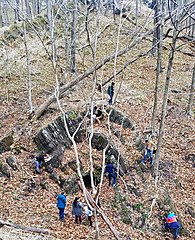
Folds are geologic structures principally formed by compressional stress. Anticlines - uparched portions of folds. Synclines - downarched portions of folds. Monoclines - kinks or bends in rock layers. Plunging folds - folds with non-horizontal axes Overturned folds - partially or completely upside-down folds. Recumbent folds - folds lying on their sides. Drag folds - bent rock layers immediately adjacent to faults. The anticline seen here is in the Appalachian Mountains of western Maryland. The host rocks are the Silurian-aged Wills Creek Formation. Notice the small cave developed in the axis of the fold (click on the photo to zoom in). Small-scale to large-scale folds are common in the Appalachian Mountains, which consist of three physiographic provinces. From west to east, they are: 1) the Valley & Ridge; 2) the Blue Ridge; and 3) the Piedmont. The above outcrop is in the Valley & Ridge province, which consists of folded sedimentary rocks of Paleozoic age that have been eroded into long, sublinear ridges separated by ~flat-floored valleys. To the east of here is the Blue Ridge province, which is mostly composed of Precambrian-aged basement rocks (igneous & metamorphics). The mountains of the Blue Ridge are generally rounded and not very tall. The Appalachians extend from Quebec to Alabama, go underground in the Mississippi River area, and re-emerge in the Arkansas-Oklahoma-Texas area as the Ouachita Mountains. The overall mountain chain formed as a result of three separate tectonic collision events during the Paleozoic. The earliest was the Taconic Orogeny (Late Ordovician to Early Silurian) - a volcanic island arc collided with what is now the New England area. Next was the Acadian Orogeny (Late Silurian to Devonian) - a microcontinent called Avalonia collided with eastern North America. The third and most significant mountain building event was the Allegheny Orogeny (Pennsylvanian) - Africa collided with eastern North America. This was a Pangaea supercontinent formation event. The Appalachians mostly lack the sharp-peaked mountains common to western America's Cordillera, the Andes of South America, the Alps of Europe, or the Himalayas of Asia. Compared with those geologically young mountain chains, the Appalachians are relatively old - they have been subjected to long-term erosion for about one-third of a billion years. Locality: outcrop near the eastern margin of Round Top Hill, Western Maryland Rail Trail (= formerly a railroad bed of the Western Maryland Railway), northern side of the Potomac River, along the border with West Virginia, western Washington County, western Maryland, Appalachian Mountains, eastern USA (vicinity of 39° 40' 38.9" North latitude, 78° 13' 31.0" West longitude) See info. at: en.wikipedia.org/wiki/Appalachian_Mountains |
| Date | |
| Source | https://www.flickr.com/photos/47445767@N05/31545717418/ |
| Author | James St. John |
Licensing
[edit].jpg&action=edit§ion=2)
- You are free:
- to share – to copy, distribute and transmit the work
- to remix – to adapt the work
- Under the following conditions:
- attribution – You must give appropriate credit, provide a link to the license, and indicate if changes were made. You may do so in any reasonable manner, but not in any way that suggests the licensor endorses you or your use.
| This image was originally posted to Flickr by James St. John at https://flickr.com/photos/47445767@N05/31545717418. It was reviewed on 10 August 2021 by FlickreviewR 2 and was confirmed to be licensed under the terms of the cc-by-2.0. |
File history
Click on a date/time to view the file as it appeared at that time.
| Date/Time | Thumbnail | Dimensions | User | Comment | |
|---|---|---|---|---|---|
| current | 15:27, 10 August 2021 | | 1,241 × 1,530 (2.15 MB) | Ser Amantio di Nicolao (talk | contribs) | Uploaded a work by James St. John from https://www.flickr.com/photos/47445767@N05/31545717418/ with UploadWizard |
You cannot overwrite this file.
File usage on Commons
There are no pages that use this file.
.jpg&oldid=799127262)