File:Antarctica ua.jpg
Jump to navigation
Jump to search

Size of this preview: 473 × 599 pixels. Other resolutions: 189 × 240 pixels | 379 × 480 pixels | 761 × 964 pixels.
Original file (761 × 964 pixels, file size: 264 KB, MIME type: image/jpeg)
Captions
Captions
Add a one-line explanation of what this file represents
Summary
[edit]
| Description |
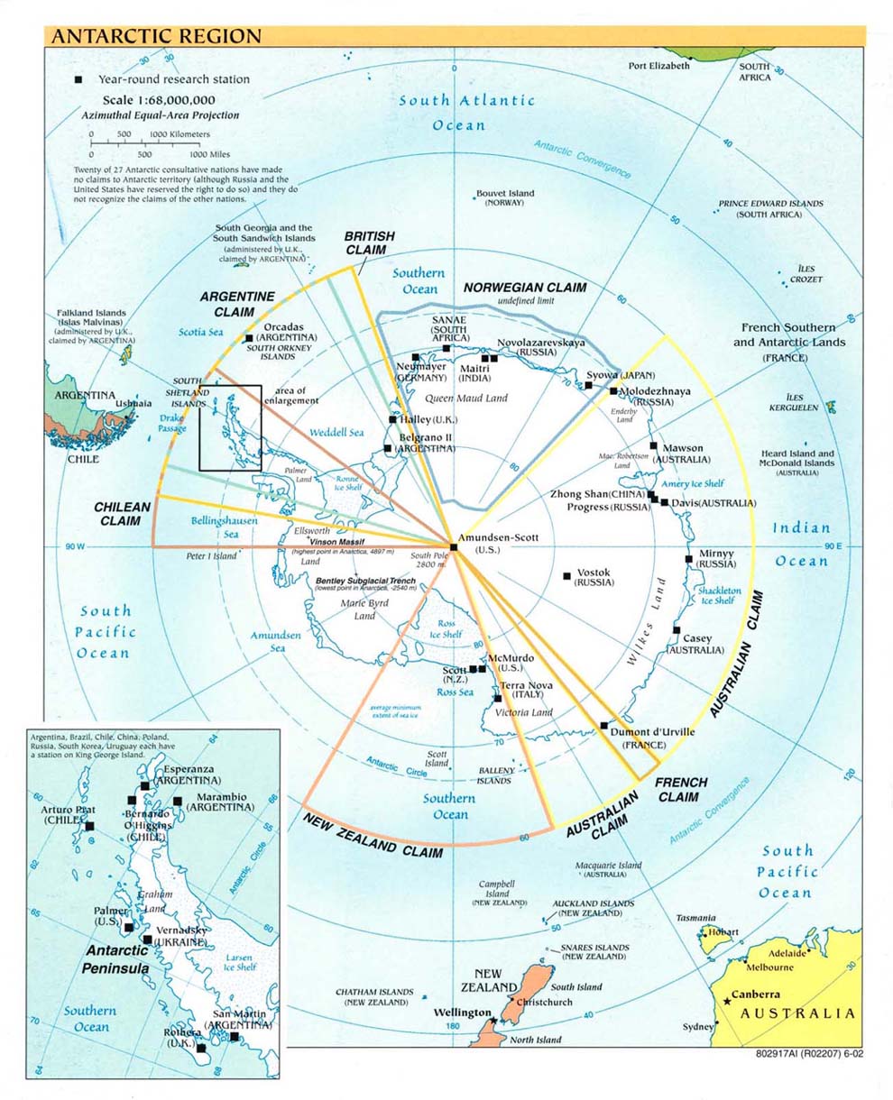
English: Political map of Antarctica showing research stations in 2002 (Ukranian)
Українська: переклад |
| Date | |
| Source | Own work from en:Image:Antarctica.jpg |
| Author | Vity OKM |
| Permission (Reusing this file) |
Public domain, produced by the U.S. Central Intelligence Agency.[1] |
| Other versions | Larger file available at: The General Libraries, The University of Texas at Austin. |

|
File:Antarctica.CIA.svg is a vector version of this file. It should be used in place of this JPG file when not inferior.
File:Antarctica ua.jpg → File:Antarctica.CIA.svg
For more information, see Help:SVG. |
 |

|
This file has been superseded by Antarctic Region.png. It is recommended to use the other file. Please note that deleting superseded images requires consent. Reason to use the other file: "A PNG version of this file is now available."
|

|
Licensing
[edit]
I, the copyright holder of this work, hereby publish it under the following license:
This file is licensed under the Creative Commons Attribution-Share Alike 4.0 International license.
- You are free:
- to share – to copy, distribute and transmit the work
- to remix – to adapt the work
- Under the following conditions:
- attribution – You must give appropriate credit, provide a link to the license, and indicate if changes were made. You may do so in any reasonable manner, but not in any way that suggests the licensor endorses you or your use.
- share alike – If you remix, transform, or build upon the material, you must distribute your contributions under the same or compatible license as the original.
This image is in the public domain because it contains materials that originally came from the United States Central Intelligence Agency's World Factbook.
|
 |
Original upload log
[edit]
16:45, 9 September 2005 . . Marknew (Talk) . . 1124x1400 (402970 bytes) (Higher quality and updated image (from PDF).)
02:39, 6 February 2005 . . Hfastedge (Talk) . . 990x1220 (210964 bytes) (Reverted to earlier revision)
01:58, 6 February 2005 . . DanQuixote (Talk) . . 519x659 (95411 bytes) (Reverted to earlier revision)
01:55, 6 February 2005 . . DanQuixote (Talk) . . 990x1220 (210964 bytes) (Antartica political map and research stations (2002))
11:49, 20 July 2002 . . . . 519x659 (95411 bytes)
File history
Click on a date/time to view the file as it appeared at that time.
| Date/Time | Thumbnail | Dimensions | User | Comment | |
|---|---|---|---|---|---|
| current | 18:45, 22 November 2014 | | 761 × 964 (264 KB) | Vity OKM (talk | contribs) | User created page with UploadWizard |
You cannot overwrite this file.
File usage on Commons
There are no pages that use this file.