File:Antarctic expedition map (Amundsen - Scott)-es.svg
Jump to navigation
Jump to search

Size of this PNG preview of this SVG file: 610 × 599 pixels. Other resolutions: 244 × 240 pixels | 489 × 480 pixels | 782 × 768 pixels | 1,042 × 1,024 pixels | 2,084 × 2,048 pixels | 1,898 × 1,865 pixels.
Original file (SVG file, nominally 1,898 × 1,865 pixels, file size: 306 KB)
Captions
Captions
Add a one-line explanation of what this file represents
Summary
[edit]| Description |
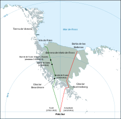
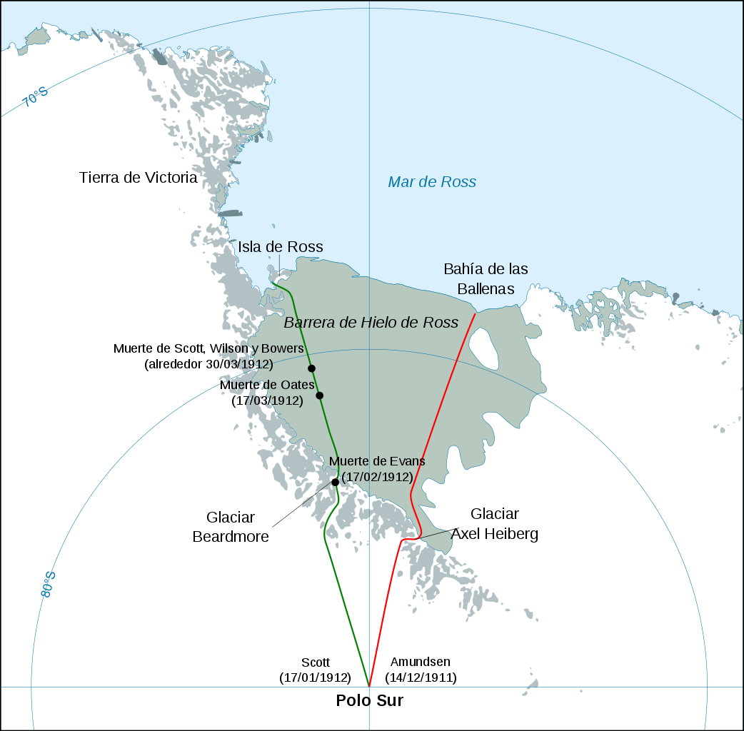
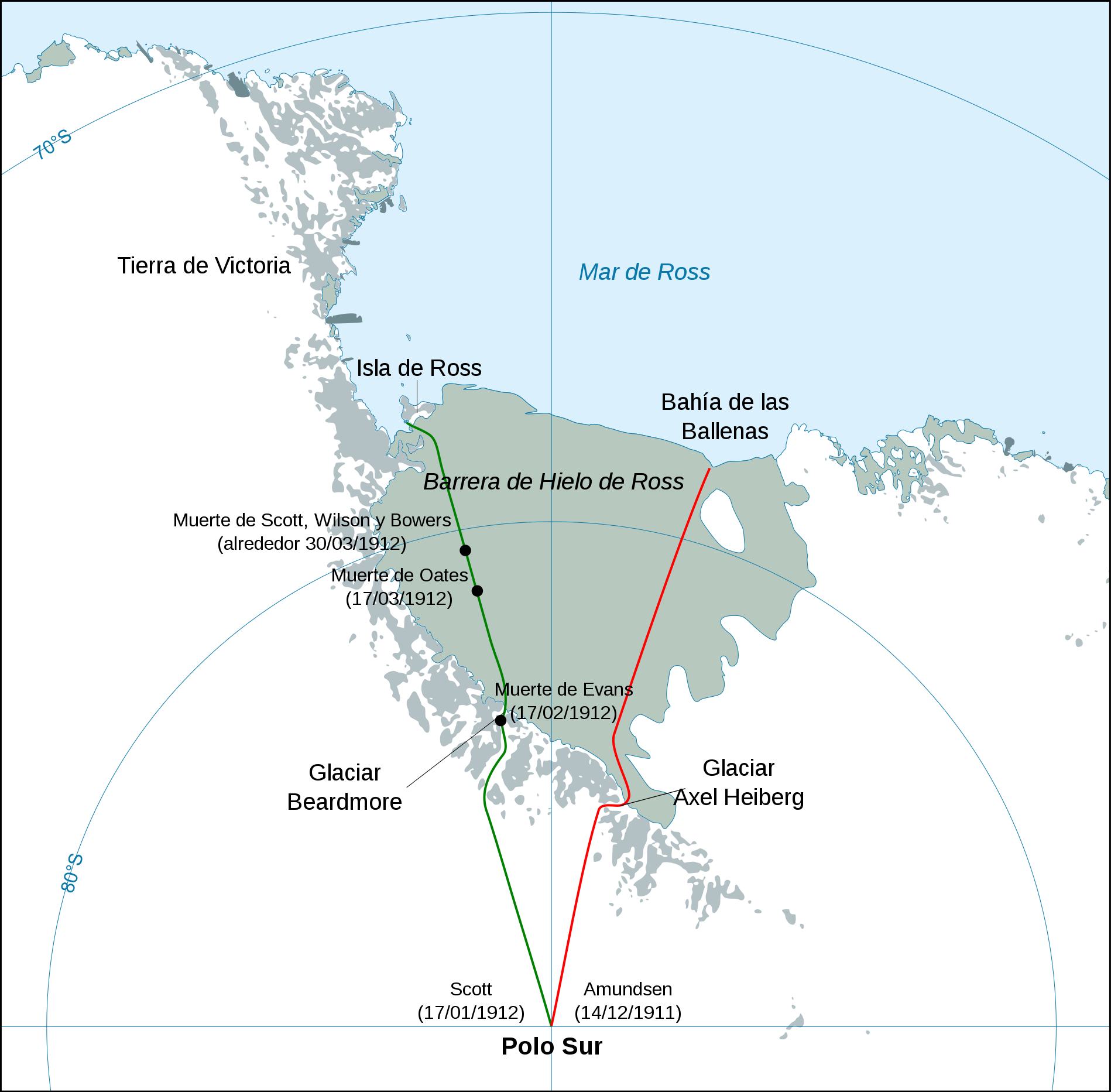
Español: Mapa mostrando las travesías polares de la expedición Terra Nova de Scott (verde) y la expedición de Amundsen (rojo) para alcanzar el Polo Sur. English: Map showing the polar journeys of the Scott's Terra Nova expedition (green) and Amundsen's expedition (red) to reach the South Pole Français : Carte montrant les parcours de l'expédition Terra Nova de Scott (vert) et celle d'Amundsen (rouge) pour atteindre le Pôle Sud |
| Date | (UTC) |
| Source |
|
| Author | Robot8A |
| Other versions |
[]
|
-ar.svg)
-bg.svg)
-ca.svg)
-cs.svg)
-cs-colorswap.svg)
-de.svg)
-el.svg)
-en.svg)
-es.svg)
-fr.svg)
-ka.svg)
-no.svg)
-ru.svg)
-he.svg)
-zh-hans.svg)
-zh-hant.svg)
-es.svg&action=edit§ion=1)
Licensing
[edit]-es.svg&action=edit§ion=2)
I, the copyright holder of this work, hereby publish it under the following license:
| I, the copyright holder of this work, release this work into the public domain. This applies worldwide. In some countries this may not be legally possible; if so: I grant anyone the right to use this work for any purpose, without any conditions, unless such conditions are required by law. |
File history
Click on a date/time to view the file as it appeared at that time.
| Date/Time | Thumbnail | Dimensions | User | Comment | |
|---|---|---|---|---|---|
| current | 22:01, 1 October 2017 | | 1,898 × 1,865 (306 KB) | Leoncastro (talk | contribs) | Error de fecha |
| 11:22, 22 June 2012 |  | 1,898 × 1,865 (306 KB) | Robot8A (talk | contribs) | == {{int:filedesc}} == {{Information |Description={{en|Map showing the polar journeys of the Scott's ''Terra Nova'' expedition (green) and Amundsen's expedition (red) to reach the South Pole}} {{fr|Carte montrant les parcours de l'expédition ''Terra N... |
You cannot overwrite this file.
File usage on Commons
The following 18 pages use this file:
- User:4ing/Antarctica/2017-10
- File:Antarctic expedition map (Amundsen - Scott)-ar.svg
- File:Antarctic expedition map (Amundsen - Scott)-bg.svg
- File:Antarctic expedition map (Amundsen - Scott)-ca.svg
- File:Antarctic expedition map (Amundsen - Scott)-cs-colorswap.svg
- File:Antarctic expedition map (Amundsen - Scott)-cs.svg
- File:Antarctic expedition map (Amundsen - Scott)-de.svg
- File:Antarctic expedition map (Amundsen - Scott)-el.svg
- File:Antarctic expedition map (Amundsen - Scott)-en.svg
- File:Antarctic expedition map (Amundsen - Scott)-es.svg
- File:Antarctic expedition map (Amundsen - Scott)-fr.svg
- File:Antarctic expedition map (Amundsen - Scott)-he.svg
- File:Antarctic expedition map (Amundsen - Scott)-ka.svg
- File:Antarctic expedition map (Amundsen - Scott)-no.svg
- File:Antarctic expedition map (Amundsen - Scott)-ru.svg
- File:Antarctic expedition map (Amundsen - Scott)-zh-hans.svg
- File:Antarctic expedition map (Amundsen - Scott)-zh-hant.svg
- Template:Other versions/Antarctic expedition map (Amundsen - Scott)
File usage on other wikis
The following other wikis use this file:
- Usage on es.wikipedia.org
- Roald Amundsen
- Robert Falcon Scott
- Barrera de hielo de Ross
- Exploración geográfica
- Glaciar Beardmore
- Expedición Terra Nova
- Expedición Amundsen
- Los perros de Amundsen en el Polo Sur
- Farthest South
- Wikiproyecto:Ilustración/Taller gráfico/Peticiones/Archivo 15
- Wikiproyecto:Ilustración/Taller gráfico/Peticiones/Archivo 2017 10
- Usage on es.wikibooks.org
- Usage on gl.wikipedia.org
-es.svg&oldid=798905290)