File:Anguilla islands.svg
Jump to navigation
Jump to search

Size of this PNG preview of this SVG file: 800 × 402 pixels. Other resolutions: 320 × 161 pixels | 640 × 322 pixels | 1,024 × 514 pixels | 1,280 × 643 pixels | 2,560 × 1,286 pixels | 1,694 × 851 pixels.
Original file (SVG file, nominally 1,694 × 851 pixels, file size: 80 KB)
Captions
Captions
Add a one-line explanation of what this file represents
Summary
[edit]| Description |
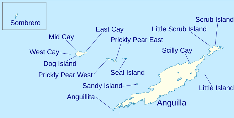
Italiano: Isole di Anguilla. English: Anguilla islands |
| Date | (UTC) |
| Source |
This file was derived from: Anguilla location map.svg: |
| Author |
|
| Other versions |
|

| This is a retouched picture, which means that it has been digitally altered from its original version. Modifications: Named islands. The original can be viewed here: Anguilla location map.svg:
|
Licensing
[edit]
I, the copyright holder of this work, hereby publish it under the following license:
This file is licensed under the Creative Commons Attribution-Share Alike 2.0 Generic license.
- You are free:
- to share – to copy, distribute and transmit the work
- to remix – to adapt the work
- Under the following conditions:
- attribution – You must give appropriate credit, provide a link to the license, and indicate if changes were made. You may do so in any reasonable manner, but not in any way that suggests the licensor endorses you or your use.
- share alike – If you remix, transform, or build upon the material, you must distribute your contributions under the same or compatible license as the original.
Original upload log
[edit]
This image is a derivative work of the following images:
- File:Anguilla_location_map.svg licensed with Cc-by-sa-2.0
- 2010-05-03T18:34:09Z NordNordWest 1777x1604 (57522 Bytes) == {{int:filedesc}} == {{Information |Description= {{de|Positionskarte von [[:de:Anguilla|Anguilla]]}} Geographische Begrenzung der Karte: * N: 18.62° N * S: 18.14° N * W: 63.46° W * O: 62.90° W {{en|Location map of [[:en
Uploaded with derivativeFX
File history
Click on a date/time to view the file as it appeared at that time.
| Date/Time | Thumbnail | Dimensions | User | Comment | |
|---|---|---|---|---|---|
| current | 22:22, 11 July 2013 | | 1,694 × 851 (80 KB) | Yiyi (talk | contribs) | == {{int:filedesc}} == {{Information |Description={{it|Isole di Anguilla.}}{{en|Anguilla islands}} |Source={{Derived from|Anguilla_location_map.svg|display=50}} |Date=2013-07-11 22:20 (UTC) |Author=*[[:File:Anguilla_location_ma... |
You cannot overwrite this file.
File usage on Commons
The following page uses this file:
File usage on other wikis
The following other wikis use this file:
- Usage on en.wikipedia.org
- Usage on fr.wikipedia.org
- Usage on hr.wikipedia.org
- Usage on it.wikipedia.org
- Usage on ko.wikipedia.org
- Usage on nl.wikipedia.org
- Usage on pt.wikipedia.org
- Usage on uk.wikipedia.org