File:Anglo-Romance Language World.PNG
Jump to navigation
Jump to search
Size of this preview: 800 × 370 pixels. Other resolutions: 320 × 148 pixels | 640 × 296 pixels | 1,199 × 555 pixels.
Original file (1,199 × 555 pixels, file size: 158 KB, MIME type: image/png)
Captions
Captions
Add a one-line explanation of what this file represents
Summary
[edit]

|
This linguistic map image could be re-created using vector graphics as an SVG file. This has several advantages; see Commons:Media for cleanup for more information. If an SVG form of this image is available, please upload it and afterwards replace this template with
{{vector version available|new image name}}.
It is recommended to name the SVG file “Anglo-Romance Language World.svg”—then the template Vector version available (or Vva) does not need the new image name parameter. |
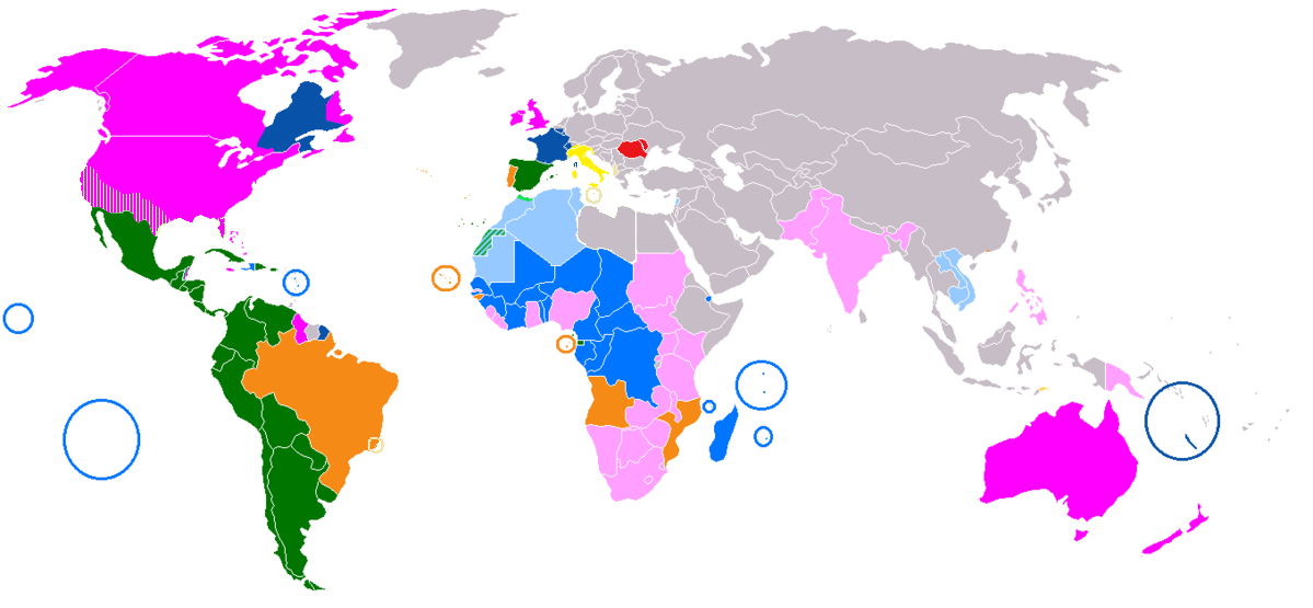
| Description | A combination of Image:Map-Romance Language World.png (Romance languages) and Image:Anglospeak.svg |
| Date | |
| Source | Own work |
| Author | 16@r |
Licensing
[edit]
| I, the copyright holder of this work, release this work into the public domain. This applies worldwide. In some countries this may not be legally possible; if so: I grant anyone the right to use this work for any purpose, without any conditions, unless such conditions are required by law. |
File history
Click on a date/time to view the file as it appeared at that time.
| Date/Time | Thumbnail | Dimensions | User | Comment | |
|---|---|---|---|---|---|
| current | 12:53, 29 November 2018 | | 1,199 × 555 (158 KB) | Memnone di Rodi (talk | contribs) | Added Italian in Corsica and Nice |
| 12:50, 29 November 2018 |  | 1,199 × 555 (158 KB) | Memnone di Rodi (talk | contribs) | Change colour of lands where Italian is widely spoken but not official, used shapes for Spanish in the USA and Belize, because there's widely spoken English too - setting the "widely spoken" limit to 10% of total population, Libya is eliminated by lands where Italian is widely spoken, while the Brazilian communities of Santa Teresa and Vila Velha are added | |
| 13:36, 3 April 2018 |  | 1,357 × 628 (39 KB) | Maphobbyist (talk | contribs) | Montenegro border | |
| 13:11, 3 April 2018 |  | 1,357 × 628 (39 KB) | Maphobbyist (talk | contribs) | Striped darker green because Spanish is an official language of Polisario in W. Sahara, light blue because is French is spoken by the settler majority living there and is used as a working language in Western Sahara under Moroccan rule. Light green for N. Morocco where Spanish is spoken. | |
| 00:12, 9 July 2011 |  | 1,357 × 628 (51 KB) | Maphobbyist (talk | contribs) | South Sudan has become independent on July 9, 2011. Sudan and South Sudan are shown with the new international border between them. The coloring stays the same as English has offical use in the new country as well. | |
| 15:16, 10 March 2011 |  | 1,357 × 628 (51 KB) | Maphobbyist (talk | contribs) | Changed coloring: In South Africa, only 8.2% speak English as their mother language. In Jamaica and the Bahamas, English is the official and main language. In Lesotho and Swaziland English is a co-official language. | |
| 15:00, 27 January 2008 |  | 1,357 × 628 (50 KB) | 16@r (talk | contribs) | {{Information |Description=A combination of Image:Map-Romance Language World.png and Image:Anglospeak.svg |Source=self-made |Date=January 26, 2008 |Author= 16@r |Permission= |other_versions= }} |
You cannot overwrite this file.
File usage on Commons
The following 2 pages use this file: