File:Angers (Maine-et-Loire) (11223361635).jpg

Original file (4,928 × 3,264 pixels, file size: 6.83 MB, MIME type: image/jpeg)
Captions
Captions
Summary
[edit]_(11223361635).jpg&action=edit§ion=1)
| Description |
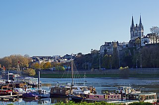
La Cale de la Savatte (Le port fluvial d'Angers). Le quai de la Savatte n'a rien à voir avec une quelconque chaussure, c'était une pièce de bois sur laquelle reposaient les navires à fond plat, les gabares. Jusque vers 1860, la Maine serpentait entre des îlots de prairies qui la divisaient en plusieurs bras. La plus grande de ces îles, l’île de la Savatte était bâtie. L’île de la Savatte, seule île bâtie, est aussi appelée île des Carmes, suite à l’établissement d’un couvent de l’ordre mendiant des Carmes en 1368. On appelait le bras de Maine entre la Doutre et l’île, le canal de la Tannerie. C’était un endroit malodorant, à cause des tanneurs qui y avaient installé leur industrie. A partir des premières décennies du XIXe siècle sont véritablement construits des quais, même si les projets en remontaient au moins à 1630. La métamorphose se poursuit après l'inondation de 1856 qui suscite en 1861 un programme d’assainissement et d’exhaussement des "bas quartiers" avec l’aide de l’État. Il faut vingt ans pour métamorphoser la rive droite. L’île de la Savatte est réunie à la Doutre en 1863-1865 avec les déblais du boulevard Descazeaux. En 1869, on creuse cette prairie pour créer la cale de la Savatte, entourée de nouveaux quais empierrés et utilisée comme port au sable jusqu’en 1984. Le quai des Carmes bâti en 1872-1878 et son prolongement jusqu’à la Haute-Chaîne seront achevés en 1883. Par la suite, le tracé de la rivière n’évolue plus de façon fondamentale. Depuis, la cale est devenue un port de plaisance.
The wharf Savatte has nothing to do with any shoe, it was a piece of wood on which rested the ships flat bottom, the scows.. Until 1860 , the Maine snaked between grassland patches which divided into several branches . The largest of these islands, the island of Savatte was built. The island of Savatte only island built , is also called Island of the Carmes , following the establishment of a convent of Carmes mendicant order in 1368. Maine 's arm was called between Doutre and the island, the channel Tannery . It was a smelly place , because tanners who had installed their industry. From the first decades of the nineteenth century are truly built docks , even if projects dating back at least to 1630 . The metamorphosis continues after the flood of 1856 which raises in 1861 a sanitation program and uplift of " slums " with the help of the state. It takes twenty years to transform the right bank. The island is joined to the Savatte Doutre in 1863-1865 with muck Boulevard Descazeaux . In 1869, we dig this meadow to create the hold of Savatte surrounded by new platforms and stony sand used as port until 1984. Quai des Carmelites built in 1872-1878 and its extension to the Upper Channel will be completed in 1883. Thereafter, the route of the river no longer changes fundamentally. Since the wedge became a marina . |
| Date | Taken on 30 November 2013, 12:00 |
| Source | Angers (Maine-et-Loire) |
| Author | Daniel Jolivet |
| Camera location | | View this and other nearby images on: OpenStreetMap |
|---|
_(11223361635).jpg¶ms=047.471822_N_-000.564273_E_globe:Earth_type:camera_source:Flickr_&language=en)
Licensing
[edit]_(11223361635).jpg&action=edit§ion=2)
- You are free:
- to share – to copy, distribute and transmit the work
- to remix – to adapt the work
- Under the following conditions:
- attribution – You must give appropriate credit, provide a link to the license, and indicate if changes were made. You may do so in any reasonable manner, but not in any way that suggests the licensor endorses you or your use.
| This image was originally posted to Flickr by sybarite48 at https://flickr.com/photos/26082117@N07/11223361635 (archive). It was reviewed on 14 November 2017 by FlickreviewR 2 and was confirmed to be licensed under the terms of the cc-by-2.0. |
File history
Click on a date/time to view the file as it appeared at that time.
| Date/Time | Thumbnail | Dimensions | User | Comment | |
|---|---|---|---|---|---|
| current | 15:41, 14 November 2017 | | 4,928 × 3,264 (6.83 MB) | Thesupermat2 (talk | contribs) | Transferred from Flickr via Flickr2Commons |
You cannot overwrite this file.
File usage on Commons
There are no pages that use this file.
_(11223361635).jpg&oldid=795522406)