File:Andaman islands.png
Jump to navigation
Jump to search

Size of this preview: 800 × 564 pixels. Other resolutions: 320 × 225 pixels | 640 × 451 pixels | 1,024 × 721 pixels | 1,350 × 951 pixels.
Original file (1,350 × 951 pixels, file size: 1.34 MB, MIME type: image/png)
Captions
Captions
Add a one-line explanation of what this file represents
Summary
[edit]
| Description |
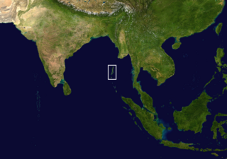
English: Location of the Andaman Islands.
हिन्दी: अण्डमान द्वीपसमूह का स्थान। |
| Date | |
| Source | Own work based on: Whole world - land and oceans 12000.jpg |
| Author | Saurmandal |
| Camera location | | View this and other nearby images on: OpenStreetMap |
|---|
Licensing
[edit]
| This file is in the public domain in the United States because it was solely created by NASA. NASA copyright policy states that "NASA material is not protected by copyright unless noted". (See Template:PD-USGov, NASA copyright policy page or JPL Image Use Policy.) | ||
 |
Warnings:
|
File history
Click on a date/time to view the file as it appeared at that time.
| Date/Time | Thumbnail | Dimensions | User | Comment | |
|---|---|---|---|---|---|
| current | 04:07, 10 September 2023 | | 1,350 × 951 (1.34 MB) | Saurmandal (talk | contribs) | adjust |
| 03:57, 10 September 2023 |  | 1,350 × 951 (1.19 MB) | Saurmandal (talk | contribs) | centering around Andaman & Nicobar UT | |
| 03:36, 10 September 2023 |  | 1,350 × 951 (1.46 MB) | Saurmandal (talk | contribs) | Uploaded a work by Saurmandal from {{Own based|Whole world - land and oceans 12000.jpg}} with UploadWizard |
You cannot overwrite this file.
File usage on Commons
There are no pages that use this file.