File:Ancil Gatliff House.jpg
Original file (6,016 × 4,000 pixels, file size: 6.55 MB, MIME type: image/jpeg)
Captions
This is an image of a place or building that is listed on the National Register of Historic Places in the United States of America. Its reference number is 80001689. |
Camera location | 36° 44′ 27″ N, 84° 09′ 41″ W | View this and other nearby images on: OpenStreetMap | 36.740833; -84.161389 |
---|
DescriptionAncil Gatliff House.jpg |
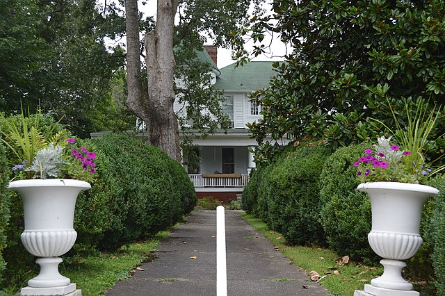
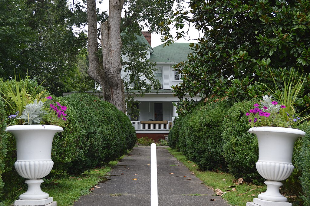
English: Front of the Dr. Ancil Gatliff House, located on the southern side of Fifth Street at the Main Street (Kentucky Route 296) intersection in Williamsburg, Kentucky, United States. Built in 1885, it is listed on the National Register of Historic Places. |
|||
Date | Taken on 25 July 2014 | |||
Source | Own work | |||
Author | Nyttend | |||
Permission (Reusing this file) |
|
File history
Click on a date/time to view the file as it appeared at that time.
Date/Time | Thumbnail | Dimensions | User | Comment | |
---|---|---|---|---|---|
current | 20:34, 24 August 2014 | 6,016 × 4,000 (6.55 MB) | Nyttend (talk | contribs) | {{NRHP|80001689}} {{Location|36|44|27|N|84|9|41|W}} {{Information |Description={{en|Front of the {{w|Dr. Ancil Gatliff House}}, located on the southern side of Fifth Street at the Main Street ({{w|Kentucky Route 296}}) intersection in {{w|Williamsburg,... |
You cannot overwrite this file.
File usage on Commons
There are no pages that use this file.
File usage on other wikis
The following other wikis use this file:
- Usage on en.wikipedia.org
Metadata
This file contains additional information such as Exif metadata which may have been added by the digital camera, scanner, or software program used to create or digitize it. If the file has been modified from its original state, some details such as the timestamp may not fully reflect those of the original file. The timestamp is only as accurate as the clock in the camera, and it may be completely wrong.
Camera manufacturer | NIKON CORPORATION |
---|---|
Camera model | NIKON D3200 |
Exposure time | 1/160 sec (0.00625) |
F-number | f/6.3 |
ISO speed rating | 100 |
Date and time of data generation | 12:49, 25 July 2014 |
Lens focal length | 32 mm |
Orientation | Normal |
Horizontal resolution | 300 dpi |
Vertical resolution | 300 dpi |
Software used | Ver.1.03 |
File change date and time | 12:49, 25 July 2014 |
Y and C positioning | Co-sited |
Exposure Program | Not defined |
Exif version | 2.3 |
Date and time of digitizing | 12:49, 25 July 2014 |
Meaning of each component |
|
Image compression mode | 2 |
APEX exposure bias | 0 |
Maximum land aperture | 4.3 APEX (f/4.44) |
Metering mode | Pattern |
Light source | Unknown |
Flash | Flash did not fire, compulsory flash suppression |
DateTime subseconds | 00 |
DateTimeOriginal subseconds | 00 |
DateTimeDigitized subseconds | 00 |
Supported Flashpix version | 1 |
Color space | sRGB |
Sensing method | One-chip color area sensor |
File source | Digital still camera |
Scene type | A directly photographed image |
Custom image processing | Normal process |
Exposure mode | Auto exposure |
White balance | Auto white balance |
Digital zoom ratio | 1 |
Focal length in 35 mm film | 48 mm |
Scene capture type | Standard |
Scene control | None |
Contrast | Normal |
Saturation | Normal |
Sharpness | Normal |
Subject distance range | Unknown |
GPS tag version | 2.3.0.0 |
Structured data
Items portrayed in this file
depicts
25 July 2014
36°44'26.999"N, 84°9'41.000"W
image/jpeg
9e21319cb1e2e5c328176aa81207efd71c384227
6,865,257 byte
4,000 pixel
6,016 pixel
- National Register of Historic Places with known IDs
- National Register of Historic Places missing SDC depicts
- National Register of Historic Places missing SDC location of creation
- Files with coordinates missing SDC location of creation
- United States photographs taken on 2014-07-25
- Self-published work
- PD-self
- Building-centered pictures by User:Nyttend