File:Ancient hedgebank in Chaddlewood - geograph.org.uk - 621656.jpg
Jump to navigation
Jump to search
No higher resolution available.
Ancient_hedgebank_in_Chaddlewood_-_geograph.org.uk_-_621656.jpg (640 × 427 pixels, file size: 119 KB, MIME type: image/jpeg)
Captions
Captions
Add a one-line explanation of what this file represents
Summary
[edit]
| Description |
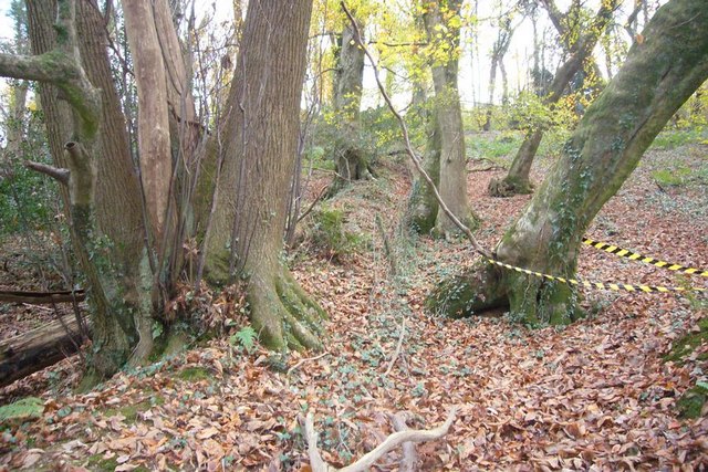
English: Ancient hedgebank in Chaddlewood This is one of three hedgebanks that are shown on the 1:25000 OS map, which run North-South. They are presumably field boundaries that pre-date the planting of the wood. They are also mirrored on the other side of the railway suggesting that they were cut through when the line was built to Plymouth in 1849. |
| Date | |
| Source | From geograph.org.uk |
| Author | Nigel Mole |
| Attribution (required by the license) | Nigel Mole / Ancient hedgebank in Chaddlewood / |
| Camera location | | View this and other nearby images on: OpenStreetMap |
|---|
_heading:157.00&language=en)
| Object location | | View this and other nearby images on: OpenStreetMap |
|---|
_heading:157.00&language=en)
Licensing
[edit]

|
This image was taken from the Geograph project collection. See this photograph's page on the Geograph website for the photographer's contact details. The copyright on this image is owned by Nigel Mole and is licensed for reuse under the Creative Commons Attribution-ShareAlike 2.0 license.
|
This file is licensed under the Creative Commons Attribution-Share Alike 2.0 Generic license.
Attribution: Nigel Mole
- You are free:
- to share – to copy, distribute and transmit the work
- to remix – to adapt the work
- Under the following conditions:
- attribution – You must give appropriate credit, provide a link to the license, and indicate if changes were made. You may do so in any reasonable manner, but not in any way that suggests the licensor endorses you or your use.
- share alike – If you remix, transform, or build upon the material, you must distribute your contributions under the same or compatible license as the original.
File history
Click on a date/time to view the file as it appeared at that time.
| Date/Time | Thumbnail | Dimensions | User | Comment | |
|---|---|---|---|---|---|
| current | 05:11, 7 February 2011 | | 640 × 427 (119 KB) | GeographBot (talk | contribs) | == {{int:filedesc}} == {{Information |description={{en|1=Ancient hedgebank in Chaddlewood This is one of three hedgebanks that are shown on the 1:25000 OS map, which run North-South. They are presumably field boundaries that pre-date the planting of the w |
You cannot overwrite this file.
File usage on Commons
There are no pages that use this file.