File:Ancient balkans 4thcentury-sr.png
Jump to navigation
Jump to search
Size of this preview: 790 × 600 pixels. Other resolutions: 316 × 240 pixels | 632 × 480 pixels | 1,012 × 768 pixels | 1,113 × 845 pixels.
Original file (1,113 × 845 pixels, file size: 88 KB, MIME type: image/png)
Captions
Captions
Add a one-line explanation of what this file represents
Summary
[edit]| Description |
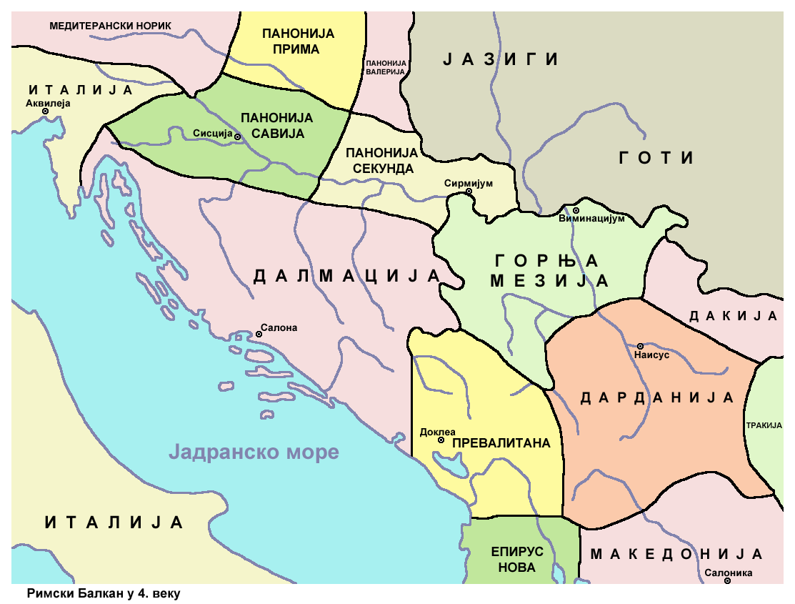
English: Ancient Roman Balkans in the 4th century. Српски / srpski: Antički rimski Balkan u 4. veku. |
| Date | |
| Source | Own work |
| Author | PANONIAN |
| Other versions |
[]
|


Licensing
[edit]
I, the copyright holder of this work, hereby publish it under the following license:
| This file is made available under the Creative Commons CC0 1.0 Universal Public Domain Dedication. | |
| The person who associated a work with this deed has dedicated the work to the public domain by waiving all of their rights to the work worldwide under copyright law, including all related and neighboring rights, to the extent allowed by law. You can copy, modify, distribute and perform the work, even for commercial purposes, all without asking permission.
|
References
[edit]
- Sima M. Ćirković, Srbi među evropskim narodima, Beograd, 2004.
- Denis Šehić - Demir Šehić, Istorijski atlas Sveta, Beograd, 2007.
- http://www.euratlas.net/history/europe/300/europe_map_0300.html
- http://xxlworld.xx.ohost.de/povijest/slike/mape/3-5cen.jpg[dead link]
- http://www.geocities.ws/lajme8reja/1111111111dardania.JPG
- http://www.orbilat.com/Maps/Latin/Balkan_Latin.gif
- http://soltdm.com/geo/arts/delta/hierocl.jpg
File history
Click on a date/time to view the file as it appeared at that time.
| Date/Time | Thumbnail | Dimensions | User | Comment | |
|---|---|---|---|---|---|
| current | 22:05, 25 November 2013 | | 1,113 × 845 (88 KB) | WikiEditor2004 (talk | contribs) | {{Information |Description ={{en|1=Ancient Roman Balkans in the 4th century.}} |Source ={{own}} |Author =PANONIAN |Date =2013 |Permission = |other_versions = }} |
You cannot overwrite this file.
File usage on Commons
The following 6 pages use this file:
File usage on other wikis
The following other wikis use this file:
- Usage on sh.wikipedia.org
- Usage on sr.wikipedia.org
- Сарајево
- Дарданци
- Сићевачка клисура
- Историја Црне Горе
- Историја Далмације
- Далмација (римска провинција)
- Историја Срба
- Горња Мезија
- Словенско насељавање Балканског полуострва
- Далмација
- Медијана (Ниш)
- Превалис
- Шумадија и западна Србија
- Дарданија (римска провинција)
- Панонија Савија
- Белопаланачка котлина
- Дарданија у итинерарима
- Рударски центри у Дарданији
Categories:
- Maps of the history of the ancient Balkans
- Maps of the history of Croatia in ancient times
- Maps of the history of Dalmatia
- Maps of the history of Slavonia
- Maps of the history of Bosnia and Herzegovina in ancient times
- Maps of the history of Montenegro in ancient times
- Maps of the history of Serbia in ancient times
- Maps of the history of Vojvodina
- Maps of the history of Syrmia
- Maps of the history of Kosovo in ancient times
- Maps of the history of Albania in ancient times
- Maps of the history of North Macedonia in ancient times
- Roman provinces (Balkans)
- Maps of Illyricum
- Maps of Roman Dalmatia
- Maps of Roman Praevalitana
- Maps of Roman Pannonia
- Moesia Prima
- Dardania (Roman Empire)
- Dacia Aureliana
- Maps of the Goths
- Iazyges
- Serbian-language maps