File:An actual survey of the sea coast from New York to the I. Cape Brition, with tables of the direct and thwart courses & distances from place to place. LOC 74694144.jpg
Jump to navigation
Jump to search

Size of this preview: 800 × 363 pixels. Other resolutions: 320 × 145 pixels | 640 × 290 pixels | 1,024 × 465 pixels | 1,280 × 581 pixels | 2,560 × 1,162 pixels | 29,857 × 13,552 pixels.
Original file (29,857 × 13,552 pixels, file size: 54.11 MB, MIME type: image/jpeg)
Captions
Captions
Add a one-line explanation of what this file represents
Summary
[edit]| Warning | The original file is very high-resolution. It might not load properly or could cause your browser to freeze when opened at full size. |
|---|
| Description |
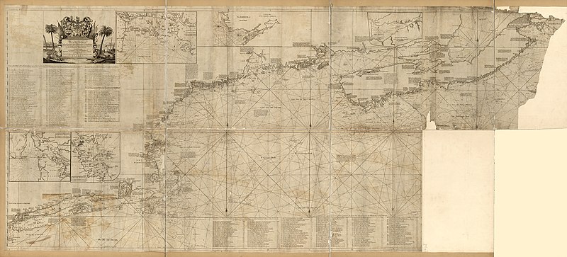
English: Scale ca. 1:590,000. Shows longitude east and west from Boston. Soundings in feet. Imperfect. Lower right section missing. Parts of upper right section torn away. Includes tables, distance charts, and insets of New York, Boston, and Halifax harbors, Casco Bay, and Annapolis Royal. Available also through the Library of Congress Web site as a raster image. Vault AACR2: 651/1; 650/2; 651/3; 651/4; 710 |
||
| Title | An actual survey of the sea coast from New York to the I. Cape Brition, with tables of the direct and thwart courses & distances from place to place. | ||
| Shelf ID | G3321.P5 1775 .S6 | ||
| Date | |||
| Source | https://www.loc.gov/item/74694144/ | ||
| Author | Southack, Cyprian; Jno. Mount And Tho. Page | ||
| Permission (Reusing this file) |
|
||
| Location | Canada · United States · Maritime Provinces · New England · North America · Atlantic Coast | ||
| Part of | Military Battles And Campaigns · American Memory · Catalog · Geography And Map Division · American Revolution And Its Era: Maps And Charts Of North America And The West Indies, 1750-1789 | ||
| Subject | Canada · United States · Maritime Provinces · Atlantic Coast (North America) · New England · Coasts · Nautical Charts · North America · Maps · Early Works To 1800 · Atlantic Coast |

Licensing
[edit]
|
This is a faithful photographic reproduction of a two-dimensional, public domain work of art. The work of art itself is in the public domain for the following reason:
The official position taken by the Wikimedia Foundation is that "faithful reproductions of two-dimensional public domain works of art are public domain".
This photographic reproduction is therefore also considered to be in the public domain in the United States. In other jurisdictions, re-use of this content may be restricted; see Reuse of PD-Art photographs for details. | ||||
File history
Click on a date/time to view the file as it appeared at that time.
| Date/Time | Thumbnail | Dimensions | User | Comment | |
|---|---|---|---|---|---|
| current | 07:03, 7 June 2018 | | 29,857 × 13,552 (54.11 MB) | Fæ (talk | contribs) | LOC Maps https://www.loc.gov/item/74694144/ #7359 |
You cannot overwrite this file.
File usage on Commons
The following page uses this file: