File:An accurate map of the island of Barbadoes. Drawn from an actual survey containing all the towns, churches, fortifications, roads, paths, plantations etc. LOC 74693270.jpg
Jump to navigation
Jump to search

Size of this preview: 713 × 599 pixels. Other resolutions: 286 × 240 pixels | 571 × 480 pixels | 914 × 768 pixels | 1,218 × 1,024 pixels | 2,437 × 2,048 pixels | 5,485 × 4,610 pixels.
Original file (5,485 × 4,610 pixels, file size: 4.18 MB, MIME type: image/jpeg)
Captions
Captions
Add a one-line explanation of what this file represents
Summary
[edit]| Description |
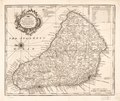
English: Scale ca. 1:85,000. Relief shown pictorially. "No. 69." From the author's A complete atlas, or distinct view of the known world. 1752. Includes list of parishes with size in acres. LC Maps of North America, 1750-1789, 2085 Available also through the Library of Congress Web site as a raster image. Vault AACR2 |
||
| Title | An accurate map of the island of Barbadoes. Drawn from an actual survey containing all the towns, churches, fortifications, roads, paths, plantations &c. | ||
| Shelf ID | G5140 1752 .B6 | ||
| Date | |||
| Source | https://www.loc.gov/item/74693270/ | ||
| Author | Bowen, Emanuel | ||
| Permission (Reusing this file) |
|
||
| Other versions |
|
||
| Location | Barbados. · Barbados | ||
| Part of | Military Battles And Campaigns · American Memory · Catalog · Geography And Map Division · American Revolution And Its Era: Maps And Charts Of North America And The West Indies, 1750-1789 | ||
| Subject | Maps · Early Works To 1800 · Administrative And Political Divisions · Barbados |

Licensing
[edit]
|
This is a faithful photographic reproduction of a two-dimensional, public domain work of art. The work of art itself is in the public domain for the following reason:
The official position taken by the Wikimedia Foundation is that "faithful reproductions of two-dimensional public domain works of art are public domain".
This photographic reproduction is therefore also considered to be in the public domain in the United States. In other jurisdictions, re-use of this content may be restricted; see Reuse of PD-Art photographs for details. | ||||
File history
Click on a date/time to view the file as it appeared at that time.
| Date/Time | Thumbnail | Dimensions | User | Comment | |
|---|---|---|---|---|---|
| current | 18:47, 15 October 2018 | | 5,485 × 4,610 (4.18 MB) | Fæ (talk | contribs) | LOC Maps https://www.loc.gov/item/74693270/ #12429 |
You cannot overwrite this file.
File usage on Commons
The following page uses this file: