File:An accurate map of North and South Carolina with their indian frontiers, shewing in a distinct manner all the mountains, rivers, swamps, marshes, bays, creeks, harbours, sandbanks and soundings on the... - btv1b530899703 (1 of 4).jpg
Jump to navigation
Jump to search

Size of this preview: 800 × 591 pixels. Other resolutions: 320 × 236 pixels | 640 × 473 pixels | 1,024 × 756 pixels | 1,280 × 945 pixels | 2,560 × 1,890 pixels | 9,621 × 7,104 pixels.
Original file (9,621 × 7,104 pixels, file size: 10.43 MB, MIME type: image/jpeg)
Captions
Captions
Add a one-line explanation of what this file represents
Summary
[edit]| Warning | The original file is very high-resolution. It might not load properly or could cause your browser to freeze when opened at full size. |
|---|
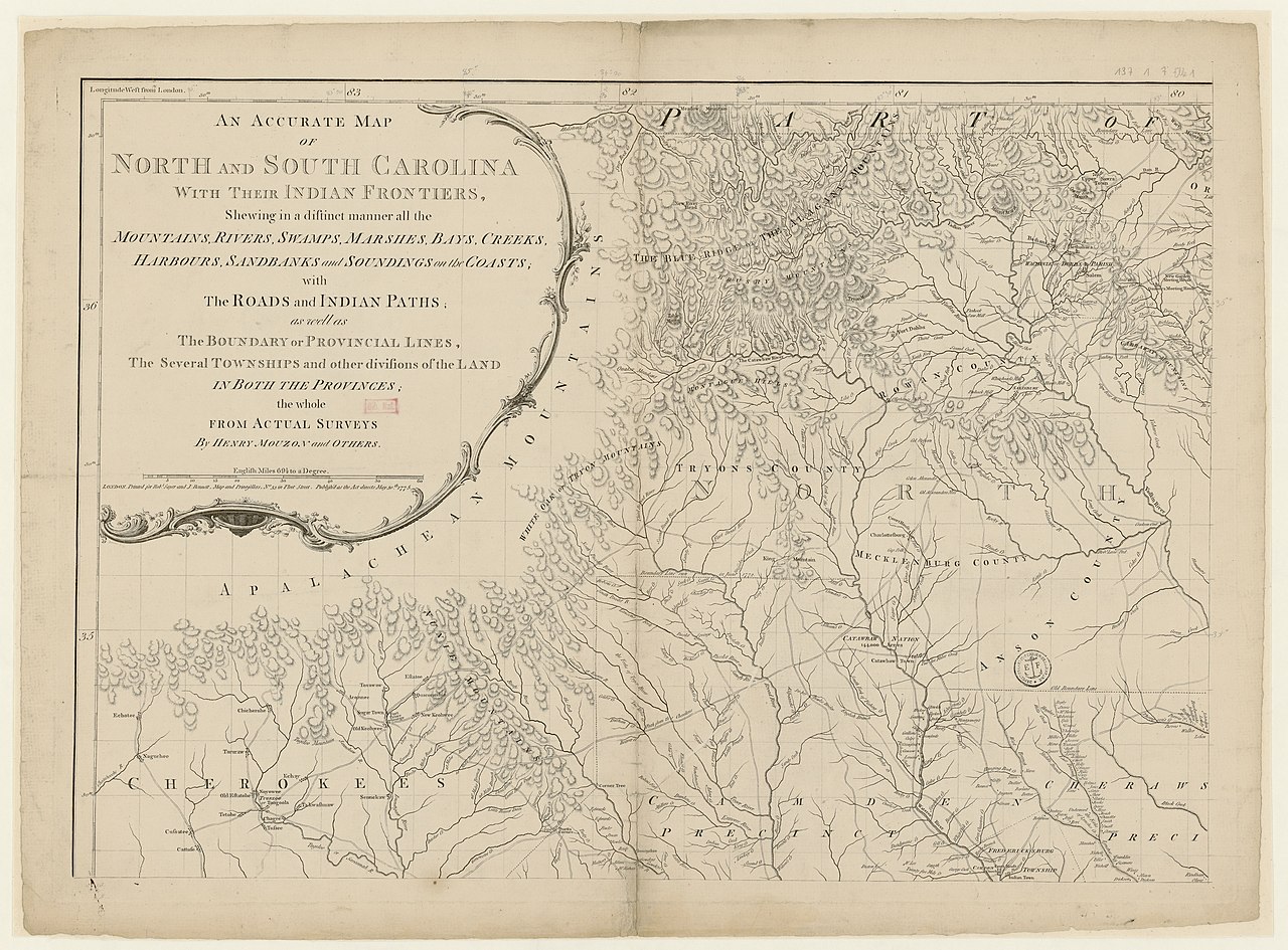
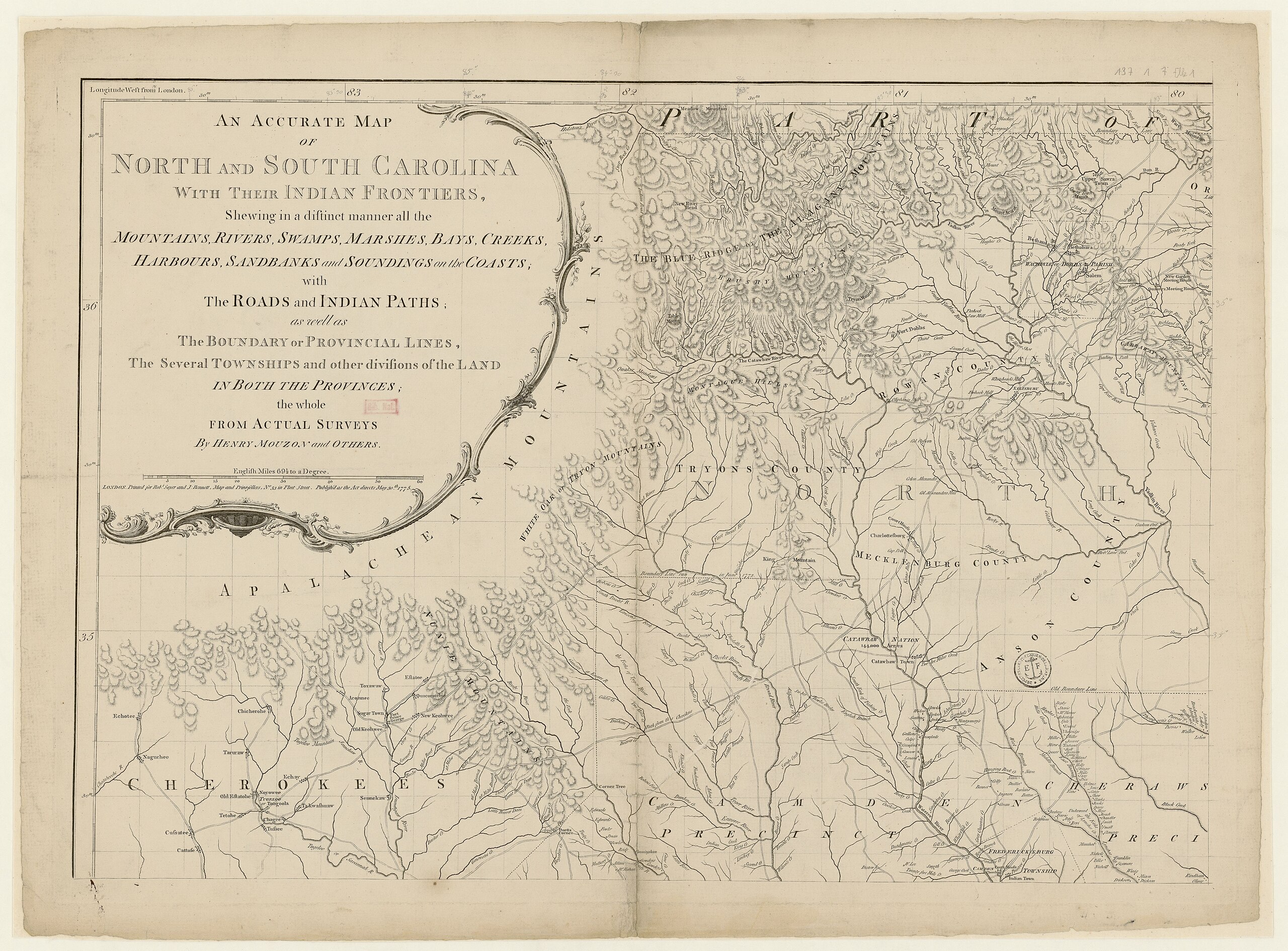
| An accurate map of North and South Carolina with their indian frontiers, shewing in a distinct manner all the mountains, rivers, swamps, marshes, bays, creeks, harbours, sandbanks and soundings on the coasts,... / by Henry Mouzon and others
( |
|||||||||||||||||||||||||||
|---|---|---|---|---|---|---|---|---|---|---|---|---|---|---|---|---|---|---|---|---|---|---|---|---|---|---|---|
| Author |
Mouzon, Henry (17..-17..?). Cartographe |
||||||||||||||||||||||||||
| Title |
An accurate map of North and South Carolina with their indian frontiers, shewing in a distinct manner all the mountains, rivers, swamps, marshes, bays, creeks, harbours, sandbanks and soundings on the coasts,... / by Henry Mouzon and others |
||||||||||||||||||||||||||
| Description |
Français : Sujet : Caroline du Nord, Colonie de
Caroline du Sud, Colonie de Couverture : États-Unis – Caroline du Nord États-Unis – Caroline du Sud Langue : anglais Éditeur : R. Sayer and J. Bennett (London) |
||||||||||||||||||||||||||
| Date | 1775 | ||||||||||||||||||||||||||
| Dimensions | height: 71 cm (27.9 in); width: 50.5 cm (19.8 in) | ||||||||||||||||||||||||||
| Collection |
|
||||||||||||||||||||||||||
| References |
Français : Notice de recueil : http://catalogue.bnf.fr/ark:/12148/cb43715151p
Appartient à : [Division 1 du portefeuille 122 du Service hydrographique de la marine consacrée aux cartes générales des deux Carolines et de la Géorgie] ; 7 Notice du catalogue : http://catalogue.bnf.fr/ark:/12148/cb43715734r |
||||||||||||||||||||||||||
| Source/Photographer |
Français : Bibliothèque nationale de France, département Cartes et plans, GE SH 18 PF 137 DIV 1 P 7
Bibliothèque nationale de France (1/4) |
||||||||||||||||||||||||||
| Permission (Reusing this file) |
|
||||||||||||||||||||||||||

.jpg&action=edit§ion=1)
.jpg&flash=no)
File history
Click on a date/time to view the file as it appeared at that time.
| Date/Time | Thumbnail | Dimensions | User | Comment | |
|---|---|---|---|---|---|
| current | 15:28, 22 July 2022 | | 9,621 × 7,104 (10.43 MB) | Gzen92Bot (talk | contribs) | Gallica btv1b530899703 |
You cannot overwrite this file.
File usage on Commons
The following page uses this file:
.jpg)
.jpg&oldid=825588098)