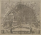
File:Amstelodamum Veteris et Novissimae Urbis Accuratissimae Delinatio second edition.jpg
From Wikimedia Commons, the free media repository
Jump to navigation
Jump to search

Size of this preview: 705 × 600 pixels. Other resolutions: 282 × 240 pixels | 564 × 480 pixels | 903 × 768 pixels | 1,204 × 1,024 pixels | 2,407 × 2,048 pixels | 3,652 × 3,107 pixels.
Original file (3,652 × 3,107 pixels, file size: 5.08 MB, MIME type: image/jpeg)
File information
Structured data
Captions
Captions
Add a one-line explanation of what this file represents
Summary
[edit]| anonymous: Map of Amsterdam with City Profile
( |
|||||||||||||||||||||
|---|---|---|---|---|---|---|---|---|---|---|---|---|---|---|---|---|---|---|---|---|---|
| Artist |
artist QS:P170,Q4233718 |
||||||||||||||||||||
| Title |
Map of Amsterdam with City Profile label QS:Len,"Map of Amsterdam with City Profile"
label QS:Lnl,"Plattegrond van Amsterdam met stadsprofiel" |
||||||||||||||||||||
| Description |
Map of Amsterdam after the Fourth Extension of the city in 1662. Most lots within this extension are still vacant. At the bottom of the sheet a profile of the city, seen from the IJ. This second edition does not contain names of designer, printmaker or publisher. The third edition contains the name of Pieter Mortier (1661-1711). It is unlikely Mortier also published the second version, since he was only 15 or 16 years old then. |
||||||||||||||||||||
| Date |
circa 1676 date QS:P571,+1676-00-00T00:00:00Z/9,P1480,Q5727902 |
||||||||||||||||||||
| Medium | etching print and engraving | ||||||||||||||||||||
| Collection |
institution QS:P195,Q2170763 |
||||||||||||||||||||
| Current location |
Collectie Atlas Splitgerber |
||||||||||||||||||||
| Accession number |
010001001031 |
||||||||||||||||||||
| Place of creation | Amsterdam | ||||||||||||||||||||
| Object history | UnknownUnknown | ||||||||||||||||||||
| Exhibition history | Het Aanzien van Amsterdam. Panorama's, plattegronden en profielen uit de Gouden Eeuw, Stadsarchief Amsterdam, Amsterdam, 19 October 2007–16 January 2008, ISBN 978-90-6868-444-5, cat. no. 11, as Map of Amsterdam with city profile, circa 1676-1680. | ||||||||||||||||||||
| References |
Stadsarchief Amsterdam, as UnknownUnknown (drawer), Amstelodamum Veteris et Novissimae Urbis Accuratissimae Delinatio, circa 1676 date QS:P,+1676-00-00T00:00:00Z/9,P1480,Q5727902 . |
||||||||||||||||||||
| Source/Photographer | beeldbank.amsterdam.nl : Home : Info | ||||||||||||||||||||
| Other versions |
|
||||||||||||||||||||
Licensing
[edit]| Public domainPublic domainfalsefalse |
|
This work is in the public domain in its country of origin and other countries and areas where the copyright term is the author's life plus 100 years or fewer. | |
| This file has been identified as being free of known restrictions under copyright law, including all related and neighboring rights. | |
https://creativecommons.org/publicdomain/mark/1.0/PDMCreative Commons Public Domain Mark 1.0falsefalse
File history
Click on a date/time to view the file as it appeared at that time.
| Date/Time | Thumbnail | Dimensions | User | Comment | |
|---|---|---|---|---|---|
| current | 08:29, 27 November 2014 |  | 3,652 × 3,107 (5.08 MB) | Vincent Steenberg (talk | contribs) | {{Information |Description ={{en|1=Map of Amsterdam with City Profile}} |Source =http://beeldbank.amsterdam.nl/afbeelding/010001001031 |Author ={{Anonymous}} |Date ={{Other date|~|1676}} |Permission = |other_versions =... |
You cannot overwrite this file.
File usage on Commons
The following 2 pages use this file:


