File:Ampleforth, St Hilda - geograph.org.uk - 106386.jpg
Jump to navigation
Jump to search
No higher resolution available.
Ampleforth,_St_Hilda_-_geograph.org.uk_-_106386.jpg (640 × 426 pixels, file size: 61 KB, MIME type: image/jpeg)
Captions
Captions
Add a one-line explanation of what this file represents
Summary
[edit]
| Description |
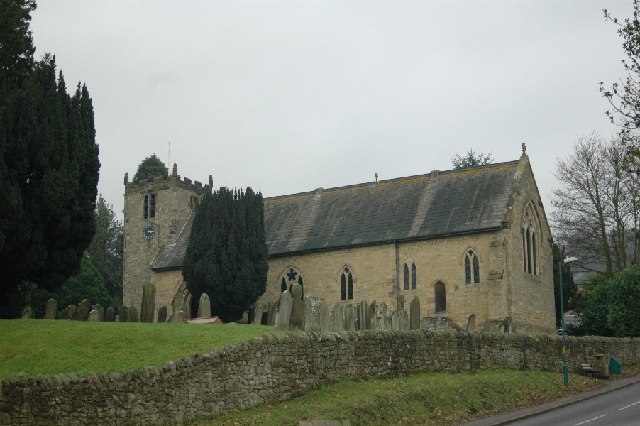
English: Ampleforth: St Hilda. Much of this church dates from a rebuilding in 1868 by T H & F Hedley but parts go back to the 11th century. Part of a group of churches today, in the 19th century it was a Vicarage within the Liberty of St Peter (ie., adminstered by York Minster) and the Prebendary of Ampleforth was the patron of (ie., held the advowson, owned and obtained profit from the tithes, presented to) the living. |
| Date | |
| Source | From geograph.org.uk |
| Author | Gareth Foster |
| Attribution (required by the license) | Gareth Foster / Ampleforth: St Hilda / |
This is a photo of listed building number 1149609. |
| Object location | | View this and other nearby images on: OpenStreetMap |
|---|
_&language=en)
Licensing
[edit]

|
This image was taken from the Geograph project collection. See this photograph's page on the Geograph website for the photographer's contact details. The copyright on this image is owned by Gareth Foster and is licensed for reuse under the Creative Commons Attribution-ShareAlike 2.0 license.
|
This file is licensed under the Creative Commons Attribution-Share Alike 2.0 Generic license.
Attribution: Gareth Foster
- You are free:
- to share – to copy, distribute and transmit the work
- to remix – to adapt the work
- Under the following conditions:
- attribution – You must give appropriate credit, provide a link to the license, and indicate if changes were made. You may do so in any reasonable manner, but not in any way that suggests the licensor endorses you or your use.
- share alike – If you remix, transform, or build upon the material, you must distribute your contributions under the same or compatible license as the original.
File history
Click on a date/time to view the file as it appeared at that time.
| Date/Time | Thumbnail | Dimensions | User | Comment | |
|---|---|---|---|---|---|
| current | 21:35, 30 January 2010 | | 640 × 426 (61 KB) | GeographBot (talk | contribs) | == {{int:filedesc}} == {{Information |description={{en|1=Ampleforth: St Hilda. Much of this church dates from a rebuilding in 1868 by T H & F Hedley but parts go back to the 11th century. Part of a group of churches today, in the 19th century it was a Vic |
You cannot overwrite this file.
File usage on Commons
The following page uses this file:
File usage on other wikis
The following other wikis use this file:
- Usage on en.wikipedia.org
- Usage on www.wikidata.org