File:American Hockey League 2011-12 map.svg
Jump to navigation
Jump to search

Size of this PNG preview of this SVG file: 601 × 600 pixels. Other resolutions: 241 × 240 pixels | 481 × 480 pixels | 770 × 768 pixels | 1,026 × 1,024 pixels | 2,053 × 2,048 pixels | 1,742 × 1,738 pixels.
Original file (SVG file, nominally 1,742 × 1,738 pixels, file size: 190 KB)
Captions
Captions
Add a one-line explanation of what this file represents
| Description |
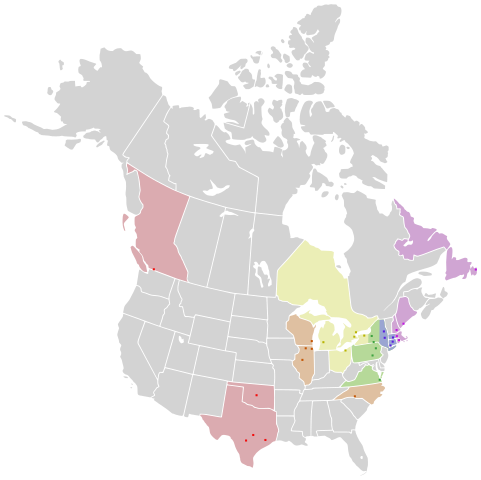
English: Map of Canada and the United States, showing the locations of American Hockey League teams as of the 2011–12 season. The cities, provinces, and states are color coded by conference and division:
Western Conference: West
Midwest
North
Eastern Conference: East
Northeast
Atlantic |
| Date | (UTC) |
| Source | |
| Author |
|
| Other versions |
Derivative works of this file: |
I, the copyright holder of this work, hereby publish it under the following license:
This file is licensed under the Creative Commons Attribution-Share Alike 2.5 Generic license.
- You are free:
- to share – to copy, distribute and transmit the work
- to remix – to adapt the work
- Under the following conditions:
- attribution – You must give appropriate credit, provide a link to the license, and indicate if changes were made. You may do so in any reasonable manner, but not in any way that suggests the licensor endorses you or your use.
- share alike – If you remix, transform, or build upon the material, you must distribute your contributions under the same or compatible license as the original.
Original upload log
[edit]
This image is a derivative work of the following images:
- File:North_America_second_level_political_division_2.svg licensed with Cc-by-sa-2.5
- 2007-12-08T23:23:36Z Lokal Profil 1712x1992 (335351 Bytes) Code cleanup
- 2007-10-07T07:55:13Z AlexCovarrubias 1712x1992 (350437 Bytes) == Summary == {{Information |Description=Map of North America and its second-level political divisions. Canadian provinces, US and Mexican states. Canada, Mexico, United States. |Source=Canada and US map by Alan Rockefeller.
Uploaded with derivativeFX
File history
Click on a date/time to view the file as it appeared at that time.
| Date/Time | Thumbnail | Dimensions | User | Comment | |
|---|---|---|---|---|---|
| current | 19:21, 15 July 2011 | | 1,742 × 1,738 (190 KB) | LtPowers (talk | contribs) | {{Information |Description={{en|Map of Canada and the United States, showing the locations of en:American Hockey League teams as of the 2011–12 season. The cities, provinces, and states are color coded by conference and division:}} '''Western |
You cannot overwrite this file.
File usage on Commons
The following 2 pages use this file: