File:America LOC 2015588081.jpg
Jump to navigation
Jump to search

Size of this preview: 776 × 600 pixels. Other resolutions: 311 × 240 pixels | 621 × 480 pixels | 994 × 768 pixels | 1,280 × 990 pixels | 2,560 × 1,979 pixels | 8,082 × 6,248 pixels.
Original file (8,082 × 6,248 pixels, file size: 6.81 MB, MIME type: image/jpeg)
Captions
Captions
Add a one-line explanation of what this file represents
Summary
[edit]| Description |
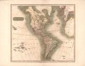
English: Relief shown pictorially. Shows major cities, political divisions, physical features, and areas of Indian habitation; Mississippi River as boundary between [French] Louisiana and the United States; Greenland, islands in the Pacific and Atlantic Oceans, western Europe, west coast of Africa, and the Mediterranean Sea. English and Spanish. Longitude based on Greenwich meridian. LC copy imperfect: Partly torn at lower edge. Includes dates of exploration on northern coast of Alaska. Available also through the Library of Congress Web site as a raster image. |
||
| Title | America | ||
| Shelf ID | G3290 1813 .T4 | ||
| Date | |||
| Source | https://www.loc.gov/item/2015588081/ | ||
| Author | Thomson, John; J. & G. Menzies | ||
| Permission (Reusing this file) |
|
||
| Other versions |
|
||
| Location | North America · Central America · South America · America · Western Hemisphere | ||
| Part of | American Memory · General Maps · Catalog · Geography And Map Division | ||
| Subject | Central America · North America · Maps · South America · Western Hemisphere · America |

Licensing
[edit]
|
This is a faithful photographic reproduction of a two-dimensional, public domain work of art. The work of art itself is in the public domain for the following reason:
The official position taken by the Wikimedia Foundation is that "faithful reproductions of two-dimensional public domain works of art are public domain".
This photographic reproduction is therefore also considered to be in the public domain in the United States. In other jurisdictions, re-use of this content may be restricted; see Reuse of PD-Art photographs for details. | ||||
File history
Click on a date/time to view the file as it appeared at that time.
| Date/Time | Thumbnail | Dimensions | User | Comment | |
|---|---|---|---|---|---|
| current | 07:24, 16 May 2018 | | 8,082 × 6,248 (6.81 MB) | Fæ (talk | contribs) | LOC Maps https://www.loc.gov/item/2015588081/ #924 |
You cannot overwrite this file.
File usage on Commons
The following page uses this file: