File:Alvastra pålbyggnad - KMB - 16001000021130.jpg
Alvastra_pålbyggnad_-_KMB_-_16001000021130.jpg (768 × 562 pixels, file size: 242 KB, MIME type: image/jpeg)
Captions
Captions
| Alvastra pålbyggnad
( |
|||||||||||||||||||||||||||
|---|---|---|---|---|---|---|---|---|---|---|---|---|---|---|---|---|---|---|---|---|---|---|---|---|---|---|---|
| Photographer |
Nerlien |
||||||||||||||||||||||||||
| Title |
Alvastra pålbyggnad |
||||||||||||||||||||||||||
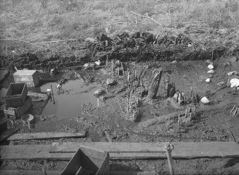
| Original caption |
Notera Av dokumentationsskäl har originalbeskrivningen från Riksantikvarieämbetet behållits. Tillrättalägganden och alternativa beskrivningar bör införas separat från nedanstående information. 1916 års schakt. Rutorna C5c - C7a från Ö. Rutorna B4b - B5d i förgrunden.Felaktigheter kan även anmälas till denna sida. Motiv: Alvastra pålbyggnad |
||||||||||||||||||||||||||
| Description |
1916 års schakt. Rutorna C5c - C7a från Ö. Rutorna B4b - B5d i förgrunden.
|
||||||||||||||||||||||||||
| Depicted place | Sweden, Ödeshög Municipality, Västra Tollstad | ||||||||||||||||||||||||||
| Date | 1916 | ||||||||||||||||||||||||||
| Collection |
|
||||||||||||||||||||||||||
| Accession number | |||||||||||||||||||||||||||
| Source |
Nerlien / Kulturmiljöbild, Riksantikvarieämbetet
|
||||||||||||||||||||||||||
| Permission (Reusing this file) |
|
||||||||||||||||||||||||||


| Object location | | View this and other nearby images on: OpenStreetMap |
|---|
File history
Click on a date/time to view the file as it appeared at that time.
| Date/Time | Thumbnail | Dimensions | User | Comment | |
|---|---|---|---|---|---|
| current | 02:36, 10 June 2017 | | 768 × 562 (242 KB) | AndreCostaWMSE-bot (talk | contribs) | {{Kulturmiljöbild-image | short title = Alvastra pålbyggnad | original description = 1916 års schakt. Rutorna C5c - C7a från Ö. Rutorna B4b - B5d i förgrunden.<br> Motiv: Alvastra pålbyggnad<br> Nyckelord: Riksintressen<br> Kategori: Boplats | w... |
You cannot overwrite this file.
File usage on Commons
The following page uses this file:
File usage on other wikis
The following other wikis use this file:
- Usage on sv.wikipedia.org