File:Alt-Kalischächte-Staßfurt.jpg
Jump to navigation
Jump to search

Size of this preview: 765 × 600 pixels. Other resolutions: 306 × 240 pixels | 612 × 480 pixels | 980 × 768 pixels | 1,280 × 1,003 pixels | 2,222 × 1,742 pixels.
Original file (2,222 × 1,742 pixels, file size: 1.65 MB, MIME type: image/jpeg)
Captions
Captions
Add a one-line explanation of what this file represents
Summary
[edit]
| Description |
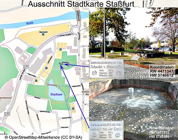
Deutsch: Ungefähre Lage der Schächte "v.d.Heydt" und "v.Manteuffel". |
| Date | |
| Source | OpenStreetMap Foundation (OSMF); ein eigenes eingefügtes Foto. [1] |
| Author | OpenStreetMap Foundation (OSMF); Integrierte Fotos, Eigentum: Dr. Günter Pinzke, aufgenommen 2010. Recherche / Einzeichnung: Dr. Günter Pinzke |
| Other versions | Attribution-ShareAlike 3.0 Unported (CC BY-SA 3.0). |
Licensing
[edit]
| I, the copyright holder of this work, release this work into the public domain. This applies worldwide. In some countries this may not be legally possible; if so: I grant anyone the right to use this work for any purpose, without any conditions, unless such conditions are required by law. |
File history
Click on a date/time to view the file as it appeared at that time.
| Date/Time | Thumbnail | Dimensions | User | Comment | |
|---|---|---|---|---|---|
| current | 05:21, 15 September 2015 | | 2,222 × 1,742 (1.65 MB) | Berginspektor (talk | contribs) | {{Information |Description=Ungefähre Lage der Alt-Kalischächte "v.d.Heydt" und "v.Manteuffel". |Source=OpenStreetMap<ref>http://www.openstreetmap.org/?lat=53.15&lon=12.3&zoom=8&layers=C</ref> |Date=2015 |Author=OpenStreetMap. Integriertes Foto: Dr. G... |
| 16:54, 9 September 2015 |  | 2,222 × 1,500 (1.03 MB) | Berginspektor (talk | contribs) | {{Information |Description=Ungefähre Lage der Schächte "v.d.Heydt" und "v.Manteuffel". . |Source=OpenStreetMap Foundation (OSMF); ein eigenes eingefügtes Foto. |Date=2015 |Author=Bearbeitung: Dr. Günter Pinzke |Permission= |o... |
You cannot overwrite this file.
File usage on Commons
The following page uses this file:
- File:KaliparkStaßfurt.jpg (file redirect)
File usage on other wikis
The following other wikis use this file:
- Usage on de.wikipedia.org
- Usage on de.wikiversity.org