File:Alps geology map en.jpg

Original file (3,338 × 1,607 pixels, file size: 1.86 MB, MIME type: image/jpeg)
Captions
Captions
source: http://en.wikipedia.org/wiki/Image:Alps_geology_map_en.jpg
Summary
[edit]
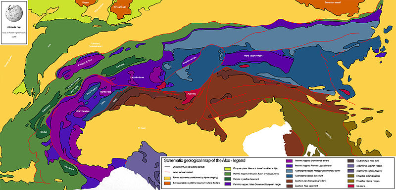
Drew this map myself.
en:User:Woodwalker
this "alps geology map" is only partly "drew by Woodwalker himself"
Woodwalker used the original "tectonic map of the alps" by stefan schmid et all and silvio lauer
https://tecto.earth.unibas.ch/research/Schmid_et_al_2004_Ecl.pdf
anyway , it is a well-done summary
14:53, 2 June 2006 (UTC)
There is an error in the name of the "Tauern Window". This is not the "Hohe Tauern" which is a mountain range in the Austrian Alps close to Salzburg rather than the "Tauern Window" which is a metamorphic window in the Alps bounded by the Katschberg Fault, SEMP fault Brenner Fault etc.. Please change the "Hohe Tauern Window" to "Tauern Window"
Licensing
[edit]
| I, the copyright holder of this work, release this work into the public domain. This applies worldwide. In some countries this may not be legally possible; if so: I grant anyone the right to use this work for any purpose, without any conditions, unless such conditions are required by law. |
File history
Click on a date/time to view the file as it appeared at that time.
| Date/Time | Thumbnail | Dimensions | User | Comment | |
|---|---|---|---|---|---|
| current | 21:24, 14 July 2008 | | 3,338 × 1,607 (1.86 MB) | Ori~ (talk | contribs) | source: http://en.wikipedia.org/wiki/Image:Alps_geology_map_en.jpg == Summary == Drew this map myself. en:User:Woodwalker 14:53, 2 June 2006 (UTC) == Licensing == {{PD-self}} |
You cannot overwrite this file.
File usage on Commons
There are no pages that use this file.
File usage on other wikis
The following other wikis use this file:
- Usage on en.wikipedia.org
- Geology of the Alps
- Periadriatic Seam
- Template:Geology of the Alps
- Helvetic (geology)
- Penninic
- Austroalpine nappes
- Southern Alps (Europe)
- Aarmassif
- Dent Blanche nappe
- Hohe Tauern window
- Ivrea zone
- Sesia zone
- Bündner schist
- Valais Ocean
- Briançonnais zone
- Piemont-Liguria Ocean
- Adriatic Plate
- Giudicarie Line
- Greywacke zone
- Rhône-Simplon line
- Lepontin dome
- Molasse basin
- Penninic thrustfront
- Engadin window
- Wetterstein Formation
- Engadine Line
- Usage on eu.wikipedia.org
- Usage on fr.wikipedia.org
- Usage on sl.wikipedia.org