File:Alperton, The Chequers public house - geograph.org.uk - 793638.jpg
Jump to navigation
Jump to search
No higher resolution available.
Alperton,_The_Chequers_public_house_-_geograph.org.uk_-_793638.jpg (640 × 464 pixels, file size: 54 KB, MIME type: image/jpeg)
Captions
Captions
Add a one-line explanation of what this file represents
Summary
[edit]
| Description |
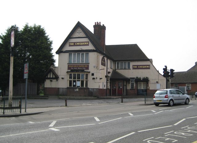
English: Alperton: The Chequers public house There has been a licensed premises known as The Chequers on this site, at the junction of Ealing Road and Stanley Avenue, since at least 1751. However it would appear that the pub's days are numbered because Brent Council have, subject to several conditions being met, granted planning permission for the demolition of the pub and the erection of a new building comprising 32 self-contained flats and 2 retail units.
There is a photograph of the pub here http://www.images-of-london.co.uk/jss/product.php?xProd=3013 dating from around 1910 showing a chequerboard pattern in the main gable end, which has since disappeared, but the Art Nouveau tablet above it, with the words "The Chequers Inn", is still present. |
| Date | |
| Source | From geograph.org.uk |
| Author | Nigel Cox |
| Attribution (required by the license) | Nigel Cox / Alperton: The Chequers public house / |
| Camera location | | View this and other nearby images on: OpenStreetMap |
|---|
_heading:135.00&language=en)
| Object location | | View this and other nearby images on: OpenStreetMap |
|---|
_heading:135.00&language=en)
Licensing
[edit]

|
This image was taken from the Geograph project collection. See this photograph's page on the Geograph website for the photographer's contact details. The copyright on this image is owned by Nigel Cox and is licensed for reuse under the Creative Commons Attribution-ShareAlike 2.0 license.
|
This file is licensed under the Creative Commons Attribution-Share Alike 2.0 Generic license.
Attribution: Nigel Cox
- You are free:
- to share – to copy, distribute and transmit the work
- to remix – to adapt the work
- Under the following conditions:
- attribution – You must give appropriate credit, provide a link to the license, and indicate if changes were made. You may do so in any reasonable manner, but not in any way that suggests the licensor endorses you or your use.
- share alike – If you remix, transform, or build upon the material, you must distribute your contributions under the same or compatible license as the original.
File history
Click on a date/time to view the file as it appeared at that time.
| Date/Time | Thumbnail | Dimensions | User | Comment | |
|---|---|---|---|---|---|
| current | 04:03, 20 February 2011 | | 640 × 464 (54 KB) | GeographBot (talk | contribs) | == {{int:filedesc}} == {{Information |description={{en|1=Alperton: The Chequers public house There has been a licensed premises known as The Chequers on this site, at the junction of Ealing Road and Stanley Avenue, since at least 1751. However it would ap |
You cannot overwrite this file.
File usage on Commons
There are no pages that use this file.