File:Almshouses - geograph.org.uk - 273601.jpg
Jump to navigation
Jump to search
No higher resolution available.
Almshouses_-_geograph.org.uk_-_273601.jpg (640 × 426 pixels, file size: 89 KB, MIME type: image/jpeg)
Captions
Captions
Add a one-line explanation of what this file represents
Summary
[edit]
| Description |
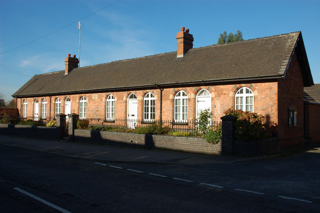
English: Almshouses The John Higgott Almshouses. The are four in total, built in 1876 for 'the poor and deserving of not less than 50 years of age, who were of good character and cleanly habits'. |
| Date | |
| Source | From geograph.org.uk |
| Author | Phil Myott |
| Attribution (required by the license) | Phil Myott / Almshouses / |
This is a photo of listed building number 1334578. |
| Object location | | View this and other nearby images on: OpenStreetMap |
|---|
_heading:315.00&language=en)
Licensing
[edit]

|
This image was taken from the Geograph project collection. See this photograph's page on the Geograph website for the photographer's contact details. The copyright on this image is owned by Phil Myott and is licensed for reuse under the Creative Commons Attribution-ShareAlike 2.0 license.
|
This file is licensed under the Creative Commons Attribution-Share Alike 2.0 Generic license.
Attribution: Phil Myott
- You are free:
- to share – to copy, distribute and transmit the work
- to remix – to adapt the work
- Under the following conditions:
- attribution – You must give appropriate credit, provide a link to the license, and indicate if changes were made. You may do so in any reasonable manner, but not in any way that suggests the licensor endorses you or your use.
- share alike – If you remix, transform, or build upon the material, you must distribute your contributions under the same or compatible license as the original.
File history
Click on a date/time to view the file as it appeared at that time.
| Date/Time | Thumbnail | Dimensions | User | Comment | |
|---|---|---|---|---|---|
| current | 19:06, 12 December 2010 | | 640 × 426 (89 KB) | GeographBot (talk | contribs) | == {{int:filedesc}} == {{Information |description={{en|1=Almshouses The John Higgott Almshouses. The are four in total, built in 1876 for 'the poor and deserving of not less than 50 years of age, who were of good character and cleanly habits'.}} |date=200 |
You cannot overwrite this file.
File usage on Commons
There are no pages that use this file.
File usage on other wikis
The following other wikis use this file:
- Usage on en.wikipedia.org
- Usage on www.wikidata.org