File:Alliance of European Conservatives and Reformists members map.svg
Jump to navigation
Jump to search

Size of this PNG preview of this SVG file: 680 × 520 pixels. Other resolutions: 314 × 240 pixels | 628 × 480 pixels | 1,004 × 768 pixels | 1,280 × 979 pixels | 2,560 × 1,958 pixels.
Original file (SVG file, nominally 680 × 520 pixels, file size: 662 KB)
Captions
Captions
Add a one-line explanation of what this file represents
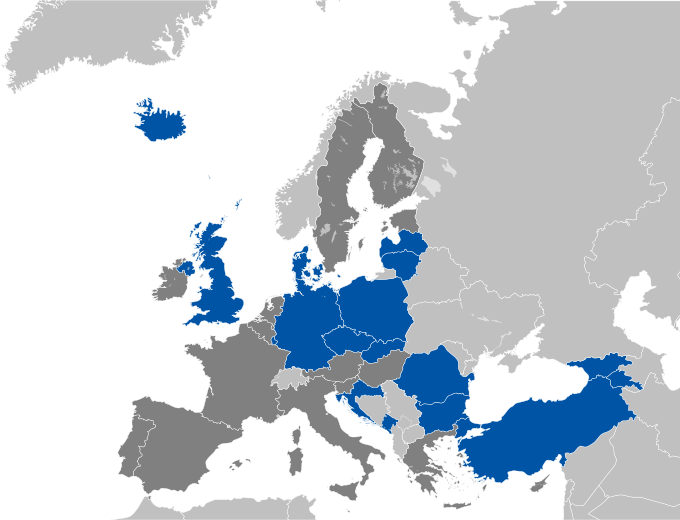
| Description | Map depicting countries in which the Alliance of European Conservatives and Reformists has member parties (blue), with EU countries in which it has no member parties in dark grey. |
| Date | (UTC) |
| Source | |
| Author |
|
| Other versions | Derivative works of this file: European Conservatives and Reformists MEPs map.svg |
I, the copyright holder of this work, hereby publish it under the following license:
This file is licensed under the Creative Commons Attribution-Share Alike 2.5 Generic license.
- You are free:
- to share – to copy, distribute and transmit the work
- to remix – to adapt the work
- Under the following conditions:
- attribution – You must give appropriate credit, provide a link to the license, and indicate if changes were made. You may do so in any reasonable manner, but not in any way that suggests the licensor endorses you or your use.
- share alike – If you remix, transform, or build upon the material, you must distribute your contributions under the same or compatible license as the original.
Original upload log
[edit]
This image is a derivative work of the following images:
- File:Blank_map_of_Europe_cropped.svg licensed with Cc-by-sa-2.5
- 2010-04-20T15:38:55Z Quibik 645x690 (266750 Bytes) Serbia had a wrong ISO code.
- 2010-04-20T14:50:17Z Quibik 645x690 (266733 Bytes) RSVG's rendering failed, trying to fix
- 2010-04-20T14:45:48Z Quibik 645x690 (264475 Bytes) further cleanup
- 2009-04-30T19:51:36Z Insuranze 645x690 (269667 Bytes) code cleanup
- 2007-06-07T22:58:16Z Revolus 645x690 (540660 Bytes) {{Information | Description=Cropped version of [[:Image:Blank map of Europe.svg|Blank map of Europe.svg]] as descriped by its author. {{en|A blank Map of Europe in SVG format. Every country has an id which is its ISO-3116-1-
Uploaded with derivativeFX
File history
Click on a date/time to view the file as it appeared at that time.
| Date/Time | Thumbnail | Dimensions | User | Comment | |
|---|---|---|---|---|---|
| current | 14:18, 25 May 2015 | | 680 × 520 (662 KB) | Bastin (talk | contribs) | Parties from Croatia (HKS) and Montenegro (PzP) have now joined. |
| 11:13, 5 October 2014 |  | 680 × 520 (673 KB) | Bastin (talk | contribs) | No Italian or Hungarian members any more. | |
| 08:51, 5 October 2014 |  | 680 × 520 (678 KB) | Bastin (talk | contribs) | Update membership (add Prosperous Armenia; add independent members from Bulgaria and Germany; remove Libertarian, Direct, Democratic) | |
| 10:47, 19 November 2013 |  | 680 × 520 (686 KB) | Bastin (talk | contribs) | Add Turkey (AK Party) and Romania (New Republic). | |
| 07:10, 12 November 2012 |  | 680 × 520 (689 KB) | Bastin (talk | contribs) | Muscardini has joined the AECR, so add Italy. | |
| 23:30, 26 August 2012 |  | 680 × 520 (689 KB) | Bastin (talk | contribs) | Add Georgia (Christian-Democratic Movement have joined) and Denmark (Anna Rosbach MEP now considered a member, per AECR website). | |
| 22:49, 21 December 2011 |  | 645 × 690 (316 KB) | Bastin (talk | contribs) | AECR now claim that TB/LNNK are a member once more. | |
| 19:58, 4 December 2011 |  | 645 × 690 (316 KB) | Bastin (talk | contribs) | The AECR now deny that Latvia's TB/LNNK (who merged into the NA) are members. So there are definitively no Latvian members, so turn to medium grey. | |
| 00:44, 14 November 2011 |  | 645 × 690 (317 KB) | Bastin (talk | contribs) | Independence Party (Iceland) has joined. | |
| 11:39, 26 March 2011 |  | 645 × 690 (317 KB) | Bastin (talk | contribs) | {{Information |Description=Map depicting countries in which the Alliance of European Conservatives and Reformists has member parties (blue), with EU countries in which it has no member parties in dark grey. |Source=*[[:File:Blank_map_of_Europe_cropped.svg |
You cannot overwrite this file.
File usage on Commons
The following page uses this file:
File usage on other wikis
The following other wikis use this file:
- Usage on ast.wikipedia.org
- Usage on fo.wikipedia.org
- Usage on ru.wikipedia.org
- Usage on uk.wikipedia.org