File:Alleys in Tbilisi HDR Photos کوچه ها در تفلیس 04.jpg
Jump to navigation
Jump to search

Size of this preview: 800 × 450 pixels. Other resolutions: 320 × 180 pixels | 640 × 360 pixels | 1,024 × 576 pixels | 1,280 × 720 pixels | 2,560 × 1,440 pixels | 5,312 × 2,988 pixels.
Original file (5,312 × 2,988 pixels, file size: 10.88 MB, MIME type: image/jpeg)
Captions
Captions
Add a one-line explanation of what this file represents
Summary
[edit]
| Description |
فارسی: کوچه راهباریکهای است که معمولاً میان یا پشت ساختمانها قرار دارد و تنها یک خودرو می تواند از آن بگذرد.
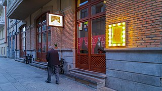
English: Cafe Theatre in Tbilisi. Samhebro street, 9
العربية: الزقاق (ج أزقّة) طريق ضيق يسمح بمرور سيارة واحدة فقط. وقد يميزه البعض بأنه أكبر قليلًا من «الزنقة» وأصغر من الحارة.
Català: Un carreró o carrer estret és un petit carrer normalment només apte per vianants que es troba a les zones urbanes que solen estar enmig o darrere dels edificis.
Dansk: Et stræde er en smal gade. Både stræder og gader har huse på begge sider og er altså et byfænomen.
Español: Un callejón es una calle estrecha que discurre en una población entre edificios altos.2 Es sinónimo de callejuela y calleja.
Esperanto: Strateto estas eta mallarĝa strato en surkonstruita areo aŭ mallarĝa kampa vojo en la kamparo. Ĝi ne havas funkcion por la trairanta trafiko.
Français : Une ruelle est une petite rue entre plusieurs bâtiments, souvent accessible uniquement pour les piétons.
Italiano: Il vicolo o vico è una strada urbana secondaria molto stretta.
Limburgs: 'n Gats is e sträötsje in aoneingeslote bebouwing (gemeinelek tösse de hoezer door) wat te smaal is veur oto's of kare en boe me dus te voot moot goon.
Nederlands: Een steeg is een smalle straat in een bebouwde omgeving of een smalle landweg op het platteland.
日本語: 路地(ろじ)とは、本来は「露地」と表記し、屋根など覆うものがない土地や地面を意味するが、狭義には密集市街地などに形成される狭い道や家と家の間の狭い道、通路などをいう。
Română: O stradelă este o stradă scurtă și îngustă; o stradă mică, străduță, ulicioară. Cuvântul provine din limba italiană: „stradella”.
Svenska: Gränd kallas en smal gata avgränsad av höga murar eller hus. Gränden är normalt så smal att biltrafik inte är möjlig på den. |
| Date | |
| Source | Own work |
| Author | Mostafameraji |
| Camera location | | View this and other nearby images on: OpenStreetMap |
|---|
Licensing
[edit]
I, the copyright holder of this work, hereby publish it under the following license:
This file is licensed under the Creative Commons Attribution-Share Alike 4.0 International license.
- You are free:
- to share – to copy, distribute and transmit the work
- to remix – to adapt the work
- Under the following conditions:
- attribution – You must give appropriate credit, provide a link to the license, and indicate if changes were made. You may do so in any reasonable manner, but not in any way that suggests the licensor endorses you or your use.
- share alike – If you remix, transform, or build upon the material, you must distribute your contributions under the same or compatible license as the original.
File history
Click on a date/time to view the file as it appeared at that time.
| Date/Time | Thumbnail | Dimensions | User | Comment | |
|---|---|---|---|---|---|
| current | 07:51, 9 November 2017 | | 5,312 × 2,988 (10.88 MB) | Mostafameraji (talk | contribs) | User created page with UploadWizard |
You cannot overwrite this file.
File usage on Commons
There are no pages that use this file.