File:All Saints Church, Tudeley - Fane tomb- coats of arms (geograph 5072424).jpg
Jump to navigation
Jump to search
No higher resolution available.
All_Saints_Church,_Tudeley_-_Fane_tomb-_coats_of_arms_(geograph_5072424).jpg (640 × 480 pixels, file size: 71 KB, MIME type: image/jpeg)
Captions
Captions
Add a one-line explanation of what this file represents
Summary
[edit].jpg&action=edit§ion=1)
| Description |
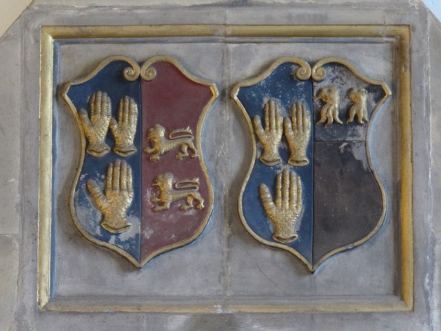
English: All Saints' Church, Tudeley, arms of Fane impaling Waller and Fane impaling Hendley, detail from top of monument to George Fane (1512-1572) Sheriff of Kent in 1557 and 1558, son of Richard Fane and his wife Agnes Stidulf, the daughter and heiress of Henry Stidulf of Badsell, the son of Thomas Stidulf and his wife Marion (née Badsell) whose brass memorial lies in the chancel. George Fane married firstly Joan Waller (d.1545) daughter of William Waller of Groombridge, in Kent/Sussex, by whom he had two sons both named Thomas Fane, the eldest of whom married Mary Neville heiress of Henry Neville 6th Baron Bergavenney; Secondly George Fane married Elizabeth Hendley, daughter of Sir Walter Hendley of Corsehorne, Cranbrooke, Kent. NB: Arms of "Waller of Groombridge" given by Burke (General Armory, 1884[1]) as Sable, three walnut trees or between two bendlets argent, not as shown here. |
| Date | |
| Source | From geograph.org.uk |
| Author | Mike Quinn |
| Permission (Reusing this file) |
Creative Commons Attribution Share-alike license 2.0 |
| Attribution (required by the license) | Mike Quinn / All Saints' Church, Tudeley - Fane tomb: coats of arms / |
| Camera location | | View this and other nearby images on: OpenStreetMap |
|---|
.jpg¶ms=051.184833_N_0000.318746_E_globe:Earth_type:camera_source:geograph-osgb36(TQ62154540)_heading:0.00&language=en)
| Object location | | View this and other nearby images on: OpenStreetMap |
|---|
.jpg¶ms=051.184830_N_0000.318750_E_globe:Earth_class:object_type:object_source:geograph-osgb36(TQ62154540)_heading:0.00&language=en)
Licensing
[edit].jpg&action=edit§ion=2)

|
This image was taken from the Geograph project collection. See this photograph's page on the Geograph website for the photographer's contact details. The copyright on this image is owned by Mike Quinn and is licensed for reuse under the Creative Commons Attribution-ShareAlike 2.0 license.
|
This file is licensed under the Creative Commons Attribution-Share Alike 2.0 Generic license.
Attribution: Mike Quinn
- You are free:
- to share – to copy, distribute and transmit the work
- to remix – to adapt the work
- Under the following conditions:
- attribution – You must give appropriate credit, provide a link to the license, and indicate if changes were made. You may do so in any reasonable manner, but not in any way that suggests the licensor endorses you or your use.
- share alike – If you remix, transform, or build upon the material, you must distribute your contributions under the same or compatible license as the original.
File history
Click on a date/time to view the file as it appeared at that time.
| Date/Time | Thumbnail | Dimensions | User | Comment | |
|---|---|---|---|---|---|
| current | 02:33, 18 November 2018 | | 640 × 480 (71 KB) | Kaliforniyka (talk | contribs) | Transferred from geograph.co.uk using [https://tools.wmflabs.org/geograph2commons/ geograph2commons] |
You cannot overwrite this file.
File usage on Commons
There are no pages that use this file.
.jpg&oldid=922591265)