File:AlgodonesDunes ISS011-E-11543.jpg
Jump to navigation
Jump to search

Size of this preview: 800 × 531 pixels. Other resolutions: 320 × 212 pixels | 640 × 424 pixels | 1,024 × 679 pixels | 1,280 × 849 pixels | 3,040 × 2,016 pixels.
Original file (3,040 × 2,016 pixels, file size: 3.24 MB, MIME type: image/jpeg)
Captions
Captions
Add a one-line explanation of what this file represents
Summary
[edit]
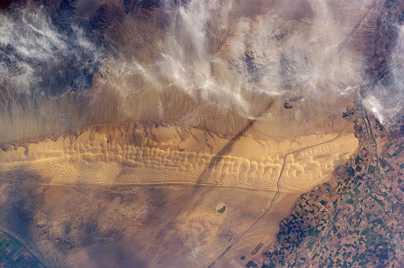
| Description | Astronaut photo of the Algodones Dunes, at the borders of California, Arizona, and Mexico. The All-American Canal cuts across the southern end of the dunes and the Cargo Muchacho Mountains can be seen beneath cloud cover at the top of the scene. Remains of the Alamo Canal are located parallel to the left side of the Colorado River (center far right of image), with the intake still visible near Pilot Knob. |
| Date | |
| Source | http://earthobservatory.nasa.gov/Newsroom/NewImages/images.php3?img_id=17098 |
| Author | ISS Crew Earth Observations experiment and the Image Science & Analysis Group, Johnson Space Center. Image cleaned up by NASA Earth Observatory |
| Permission (Reusing this file) |
US government, public domain |
| Camera location | | View this and other nearby images on: OpenStreetMap |
|---|
Licensing
[edit]
This file is in the public domain in the United States because it was created by the Image Science & Analysis Laboratory, of the NASA Johnson Space Center. NASA copyright policy states that "NASA material is not protected by copyright unless noted". (NASA media use guidelines or Conditions of Use of Astronaut Photographs).
Photo source: ISS011-E-11543.
|
| Annotations | This image is annotated: View the annotations at Commons |
File history
Click on a date/time to view the file as it appeared at that time.
| Date/Time | Thumbnail | Dimensions | User | Comment | |
|---|---|---|---|---|---|
| current | 02:48, 25 May 2013 | | 3,040 × 2,016 (3.24 MB) | Ras67 (talk | contribs) | new rendered in high resolution from NASA's raw image data |
| 23:32, 1 May 2006 |  | 1,000 × 662 (459 KB) | Holly Cheng (talk | contribs) | {{Information | Description=Astronaut photo of the w:Algodones Dunes, at the borders of California, Arizona, and Mexico. The w:All-American Canal cuts across the southern end of the dunes and the w:Cargo Muchacho Mountains can be seen beneath |
You cannot overwrite this file.
File usage on Commons
The following 3 pages use this file:
File usage on other wikis
The following other wikis use this file:
- Usage on arz.wikipedia.org
- Usage on ceb.wikipedia.org
- Usage on de.wikipedia.org
- Usage on en.wikipedia.org
- Usage on en.wikivoyage.org
- Usage on es.wikipedia.org
- Usage on fr.wikipedia.org
- Usage on ja.wikipedia.org
- Usage on lld.wikipedia.org
- Usage on sv.wikipedia.org
- Usage on www.wikidata.org