File:Alexandra Land and Prince George Land, Arctic Ocean.jpg

Original file (3,508 × 2,540 pixels, file size: 1.91 MB, MIME type: image/jpeg)
Captions
Captions
Summary
[edit]
| Description |
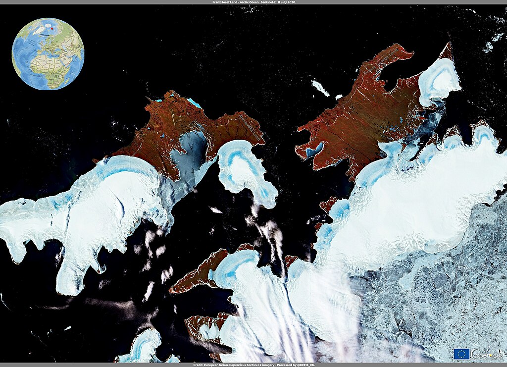
English: This False Colour image, captured by the Copernicus Sentinel-2A satellite, shows Alexandra Land and parts of Prince George Land, two islands of the Franz Joseph Land, a Russian archipelago in the north-eastern Barents Sea in the Arctic Ocean. They are located at a latitude above 80° North, about 1,000 kilometers away from the North Pole. In this region, summer thaw usually starts during July, but in 2020 thaw started at the end of June and continued during July, melting ice and snow in a shorter period of time, as a result of the Siberian heatwave. According to the climatologists of the University of Liège, the meltwater runoff had a 1,500% increase between the 1st of June and the 10th of July, compared to the average value of the reference period 1981-2010. The Copernicus Sentinel-2 mission, composed by two twin satellites, Sentinel-2A and Sentinel-2B, provides multispectral data thanks to its 13 available spectral bands, with a maximum spatial resolution of 10 metres and an average revisit time of 5 days. In higher latitudes, overlapping swaths can increase the revisit time to up to one image per day. The Copernicus Sentinel-2 mission has an important role in Arctic research applications, because it allows the retrieval of spectral albedo and the derivation of different snow properties. |
| Date | 17 July 2020 (upload date) |
| Source | Alexandra Land and Prince George Land, Arctic Ocean |
| Author | European Union , Copernicus Sentinel-2 imagery |
Licensing
[edit]

|
This image contains data from a satellite in the Copernicus Programme, such as Sentinel-1, Sentinel-2 or Sentinel-3. Attribution is required when using this image.
Attribution: Contains modified Copernicus Sentinel data 2020
The use of Copernicus Sentinel Data is regulated under EU law (Commission Delegated Regulation (EU) No 1159/2013 and Regulation (EU) No 377/2014). Relevant excerpts:
Free access shall be given to GMES dedicated data [...] made available through GMES dissemination platforms [...].
Access to GMES dedicated data [...] shall be given for the purpose of the following use in so far as it is lawful:
GMES dedicated data [...] may be used worldwide without limitations in time.
GMES dedicated data and GMES service information are provided to users without any express or implied warranty, including as regards quality and suitability for any purpose. |
File history
Click on a date/time to view the file as it appeared at that time.
| Date/Time | Thumbnail | Dimensions | User | Comment | |
|---|---|---|---|---|---|
| current | 21:04, 27 July 2023 | | 3,508 × 2,540 (1.91 MB) | OptimusPrimeBot (talk | contribs) | #Spacemedia - Upload of https://www.copernicus.eu/system/files/2020-07/image_day/FranzJosefLand.jpg via Commons:Spacemedia |
You cannot overwrite this file.
File usage on Commons
There are no pages that use this file.