File:AlemByspylsatz Ort1.svg
Jump to navigation
Jump to search

Size of this PNG preview of this SVG file: 423 × 599 pixels. Other resolutions: 169 × 240 pixels | 339 × 480 pixels | 542 × 768 pixels | 723 × 1,024 pixels | 1,446 × 2,048 pixels | 743 × 1,052 pixels.
Original file (SVG file, nominally 743 × 1,052 pixels, file size: 1.38 MB)
Captions
Captions
Add a one-line explanation of what this file represents
| Description |
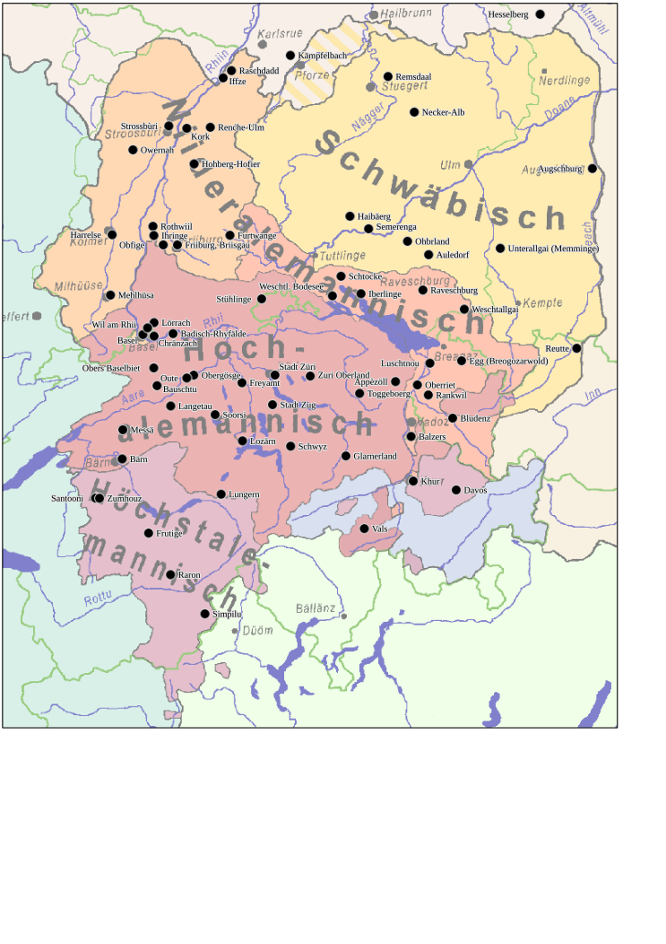
Alemannisch: Kartierung vu de Belegort vum erste alemannische Byspilsatz us dem Artikel Alemannischer Beispielsatz i de alemannische Wikipedia. Kartehintergrund: Dr alemannisch Sprochruum. Uf dr Grundlag vu dr Gliiderig vum Karl Bohnenberger, Isoglosse korrigiärt noch em Matrial vu dr Sprochatlante. Begriff un Abgränzig "Oberrhiinalemannisch" un "Bodeseealemannisch" ergänzt noch em Hugo Steger. Dr Stand vu dr Chart isch 1950. Siterhär hän sich im Bündner Land Verschiäbige zugunschte vum Alemannische ergä, usserhalb vu dr Schwiz ischs zu deilwiise Verdrängige vum Alemannische in Balligsgebiät cho - des bsunders hert im Elsass. D Gränz zwische Schwäbisch un Bodeseealemannisch isch ufgweigt un witer no Süde druckt wore. English: Geographic origins of the alemannic example sentences collected in the article Alemannischer Beispielsatz of the Alemannic Wikipedia. Background map: The Alemannic speech area, based on the division made by Karl Bohnenberger. The isoglosses have been corrected based on the dialect surveys of the Alemannic speech area. The terms and definitions of Oberrhiinalemannisch (Upper-Rhine Alemannic) and Bodeseealemannisch (Lake Constance Alemannic) have been added according to the proposals of Hugo Steger. The Map is based on the linguistic state of 1950. Since then, Alemannic has gained ground in the Canton Grisons in favour of Romansch; outside of Switzerland, Alemannic has been pushed back, especially in urban agglomerations. This can be observed most strongely in Alsace (France). The border between Swabian and Lake Constance Alemannic has dissolved and moved southward. Català: Diagrama de l'àrea lingüística de l'alamànic, basat en les divisions que va fer en Karl Bohnenberger. Les isoglosses s'han corregit segons la literatura disponible. Els termes Oberrhiinalemannisch (alamànic de l'alt Rin) i Bodeseealemannisch (alamànic del llac de Constança) s'hi han afegit d'acord amb les propostes d'en Hugo Steger. El mapa es basa en l'estat lingüístic de 1950. Des d'aleshores, l'alamànic ha guanyat terreny al cantó de Grisons a costa del romanx; fora de Suïssa, l'alamànic ha retrocedit, especialment als nuclis urbans fenòmen observable especialment a l'Alsàcia. La frontera entre el suabi i l'alamànic del llac de Constança d'ha dissolt i mogut cap el sud. |
| Date | (UTC) |
| Source | |
| Author |
|
| Other versions |
Derivative works of this file: AlemBeispielsatz Orte1 de.svg PNG:
PNG:
SVG:
SVG: SVG:
|


| This is a retouched picture, which means that it has been digitally altered from its original version. Modifications: Kartierung vu de Ort im Artikel "Alemannischer Beispielsatz". The original can be viewed here: Alemannisch.png:
|
I, the copyright holder of this work, hereby publish it under the following license:
This file is licensed under the Creative Commons Attribution-Share Alike 2.5 Generic license.
- You are free:
- to share – to copy, distribute and transmit the work
- to remix – to adapt the work
- Under the following conditions:
- attribution – You must give appropriate credit, provide a link to the license, and indicate if changes were made. You may do so in any reasonable manner, but not in any way that suggests the licensor endorses you or your use.
- share alike – If you remix, transform, or build upon the material, you must distribute your contributions under the same or compatible license as the original.
Original upload log
[edit]
This image is a derivative work of the following images:
- File:Alemannisch.png licensed with Cc-by-sa-2.5
- 2007-07-13T10:56:47Z Terfili 1831x2598 (1123982 Bytes) [[Category:Alemannic]]
Uploaded with derivativeFX
File history
Click on a date/time to view the file as it appeared at that time.
| Date/Time | Thumbnail | Dimensions | User | Comment | |
|---|---|---|---|---|---|
| current | 14:54, 29 October 2010 | | 743 × 1,052 (1.38 MB) | Ralfonso (talk | contribs) | Rand vum Layout entfernt, Ortsnäme uf alemannisch |
| 07:35, 29 October 2010 |  | 743 × 1,052 (988 KB) | Ralfonso (talk | contribs) | {{Information |Description={{als|<nowiki/> *'''Dr alemannisch Sprochruum.''' Uf dr Grundlag vu dr Gliiderig vum [http://als.wikipedia.org/wiki/Karl_Bohnenberger Karl Bohnenberger], Isoglosse korrigiärt noch em Matrial vu dr [http://als.wikipedia.org/wiki |
You cannot overwrite this file.
File usage on Commons
The following 21 pages use this file:
- File:AlemBeispielsatz Orte1 de.svg
- File:AlemByspylsatz Ort1.svg
- File:Alemannic-Dialects-Map-English.png
- File:Alemannic-Dialects-Map-English.svg
- File:Alemannic-Dialects-Map-French.png
- File:Alemannic-Dialects-Map-French.svg
- File:Alemannic-Dialects-Map-German.png
- File:Alemannic-Dialects-Map-German.svg
- File:Alemannic-Dialects-Map-Hungarian.png
- File:Alemannic-Dialects-Map-Hungarian.svg
- File:Alemannic language location map in 1950-de.svg
- File:Alemannic language location map in 1950-fr.svg
- File:Alemannic language location map in 1950 with countries-fr.svg
- File:Alemannisch-korrigiert.png
- File:Alemannisch.png
- File:Alemannisch blank.png
- File:Alemannisch hu.png
- File:Charte Alemannisch korrigiert2.svg
- File:Charte Alemannisch korrigiert 4.svg
- File:Charte Alemannisch korrigiert 5.svg
- Template:Alemannic-dialects-maps
File usage on other wikis
The following other wikis use this file:
- Usage on als.wikipedia.org