File:Albisriederplatz auf der Sigfriedkarte von 1913.png
Jump to navigation
Jump to search
Size of this preview: 599 × 600 pixels. Other resolutions: 240 × 240 pixels | 479 × 480 pixels | 649 × 650 pixels.
Original file (649 × 650 pixels, file size: 1.02 MB, MIME type: image/png)
Captions
Captions
Add a one-line explanation of what this file represents
Summary
[edit]
| Description |
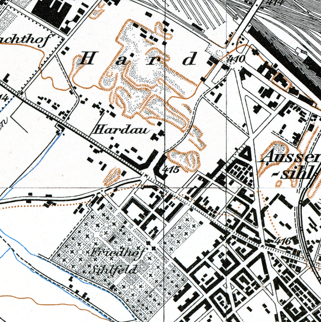
Deutsch: Albisriederplatz auf der Sigfriedkarte von 1913. Die Blockrandbebauung umschliesst erst drei Viertel des Platzes, das Hotel Stoller ist noch nicht gebaut. Nördlich des Platzes sind die Kiesgruben in der Hard sichtbar. Die Hardstrasse ist noch nicht begradigt und ausgebaut. |
||||
| Date | |||||
| Source | Ausschnitt von Blatt 158 Schlieren. Sigriedkarte. Eidgenössische Landestopographie, 1916. Datenstand 1913 | ||||
| Author | Eidgenössische Landestopographie | ||||
| Permission (Reusing this file) |
|
||||
File history
Click on a date/time to view the file as it appeared at that time.
| Date/Time | Thumbnail | Dimensions | User | Comment | |
|---|---|---|---|---|---|
| current | 13:30, 24 December 2020 | | 649 × 650 (1.02 MB) | Pechristener (talk | contribs) | {{Information |Description={{de|Albisriederplatz auf der Sigfriedkarte von 1913. Die Blockrandbebauung umschliesst erst drei Viertel des Platzes, das Hotel Stoller ist noch nicht gebaut. Nördlich des Platzes sind die Kiesgruben in der Hard sichtbar. Die Hardstrasse ist noch nicht begradigt und ausgebaut.}} |Source=Ausschnitt von Blatt 158 ''Schlieren''. Sigriedkarte. Eidgenössische Landestopographie, 1916. Datenstand 1913 |Date=1916 |Author=Eidgenössische Landestopographie |Permission={{PD-ol... |
You cannot overwrite this file.
File usage on Commons
There are no pages that use this file.
File usage on other wikis
The following other wikis use this file:
- Usage on de.wikipedia.org