File:Albion Junction and Iron Horse sculpture 63.jpg
From Wikimedia Commons, the free media repository
Jump to navigation
Jump to search
Size of this preview: 800 × 448 pixels. Other resolutions: 320 × 179 pixels | 640 × 359 pixels | 1,024 × 574 pixels | 1,280 × 717 pixels | 2,560 × 1,435 pixels | 6,000 × 3,363 pixels.
Original file (6,000 × 3,363 pixels, file size: 12.13 MB, MIME type: image/jpeg)
File information
Structured data
Captions
DescriptionAlbion Junction and Iron Horse sculpture 63.jpg |
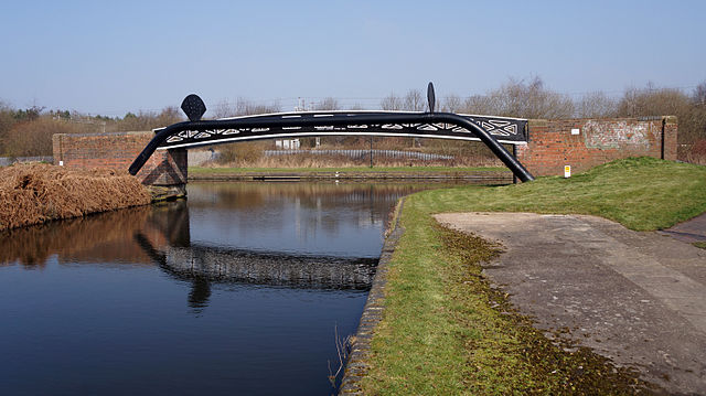
English: Albion Junction on the BCN Main Line canal ( New Main Line) in Sandwell, England.
In the distance to the left, under the bridge, is a sculpture Iron Horse, 1987, by Kevin Atherton, one of a series of twelve installed on the Stour Valley Line between Birmingham New Street railway station and Wolverhampton railway station. |
Date | Taken on 18 March 2015 |
Source | Own work |
Author | Oosoom at English Wikipedia |
Permission (Reusing this file) |
I, the copyright holder of this work, hereby publish it under the following license: This file is licensed under the Creative Commons Attribution-Share Alike 3.0 Unported license.
|
Camera location | 52° 31′ 02.64″ N, 2° 01′ 45.3″ W | View this and other nearby images on: OpenStreetMap | 52.517400; -2.029250 |
---|
File history
Click on a date/time to view the file as it appeared at that time.
Date/Time | Thumbnail | Dimensions | User | Comment | |
---|---|---|---|---|---|
current | 19:11, 18 March 2015 | 6,000 × 3,363 (12.13 MB) | Oosoom (talk | contribs) | {{Information |Description={{en|Albion Junction on the {{w|BCN Main Line}} canal ( New Main Line) in Sandwell, England. In the distance under the bridge is a sculpture ''Iron Horse'', 1987, by Kevin Atherton, one of a series of twelve installed on the... |
You cannot overwrite this file.
File usage on Commons
The following page uses this file:
File usage on other wikis
The following other wikis use this file:
- Usage on en.wikipedia.org
Metadata
This file contains additional information such as Exif metadata which may have been added by the digital camera, scanner, or software program used to create or digitize it. If the file has been modified from its original state, some details such as the timestamp may not fully reflect those of the original file. The timestamp is only as accurate as the clock in the camera, and it may be completely wrong.
Camera manufacturer | SONY |
---|---|
Camera model | SLT-A77V |
Exposure time | 1/250 sec (0.004) |
F-number | f/8 |
ISO speed rating | 100 |
Date and time of data generation | 12:13, 18 March 2015 |
Lens focal length | 18 mm |
Latitude | 52° 31′ 2.69″ N |
Longitude | 2° 1′ 45.59″ W |
Altitude | 145.78 meters above sea level |
Orientation | Normal |
Horizontal resolution | 350 dpi |
Vertical resolution | 350 dpi |
Software used | Adobe Photoshop CS4 Windows |
File change date and time | 18:30, 18 March 2015 |
Y and C positioning | Co-sited |
Exposure Program | Normal program |
Exif version | 2.3 |
Date and time of digitizing | 12:13, 18 March 2015 |
Meaning of each component |
|
Image compression mode | 3 |
APEX brightness | 9.7046875 |
APEX exposure bias | 0 |
Maximum land aperture | 3.6171875 APEX (f/3.5) |
Metering mode | Center weighted average |
Light source | Unknown |
Flash | Flash did not fire, compulsory flash suppression |
Supported Flashpix version | 1 |
Color space | sRGB |
File source | Digital still camera |
Scene type | A directly photographed image |
Custom image processing | Normal process |
Exposure mode | Auto exposure |
White balance | Auto white balance |
Focal length in 35 mm film | 27 mm |
Scene capture type | Standard |
Contrast | Normal |
Saturation | Normal |
Sharpness | Normal |
GPS time (atomic clock) | 12:13 |
Receiver status | Measurement in progress |
Measurement mode | 3-dimensional measurement |
Measurement precision | Poor (1.8323) |
Speed unit | Kilometers per hour |
Speed of GPS receiver | 1.133 |
Reference for direction of movement | True direction |
Direction of movement | 144.02 |
Geodetic survey data used | WGS-84 |
GPS date | 18 March 2015 |
GPS differential correction | 0 |
GPS tag version | 0.0.3.2 |
Supported Flashpix version | 1 |
Image width | 6,000 px |
Image height | 3,363 px |
Date metadata was last modified | 18:30, 18 March 2015 |
Unique ID of original document | xmp.did:BF60AB3F9CCDE411B102B23E9F2053D3 |
IIM version | 4,720 |