File:Alberta Wildfire 2016-05-24 MODIS.jpg
Jump to navigation
Jump to search

Size of this preview: 800 × 600 pixels. Other resolutions: 320 × 240 pixels | 640 × 480 pixels | 1,024 × 768 pixels | 1,280 × 960 pixels | 1,600 × 1,200 pixels.
Original file (1,600 × 1,200 pixels, file size: 1.56 MB, MIME type: image/jpeg)
Captions
Captions
Add a one-line explanation of what this file represents
Summary
[edit]| Description |
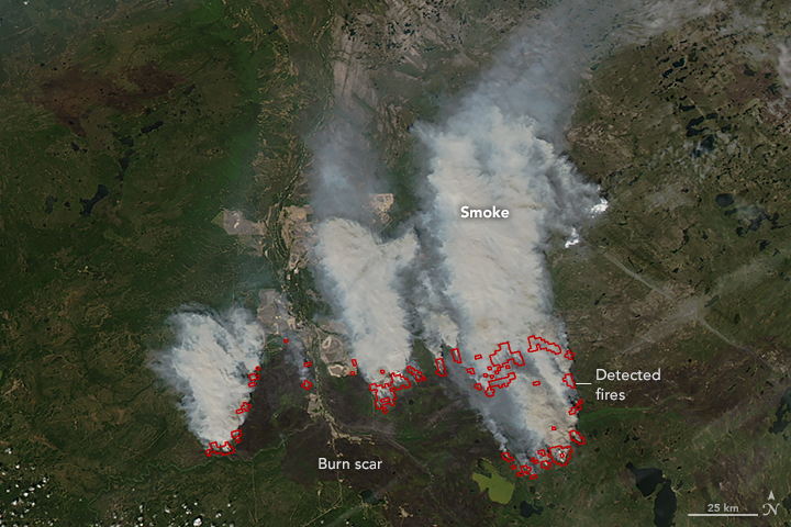
English: At 20:10 Universal Time (2:10 p.m. local time) on May 24, 2016, the Moderate Resolution Imaging Spectroradiometer (MODIS) instrument on NASA’s Aqua satellite captured a natural-color image of fires that continued to burn in Canada’s Alberta and Saskatchewan provinces. Red outlines indicate hot spots where MODIS detected warm surface temperatures associated with fires. Thick plumes of smoke were blowing northward.
When this image was acquired, the Fort McMurray fire remained out of control and was burning under high to extreme fire conditions. The fire had already consumed 5,229 square kilometers (2019 square miles). |
|||||
| Date | ||||||
| Source | http://eoimages.gsfc.nasa.gov/images/imagerecords/88000/88090/Alberta_amo_2016145.jpg http://earthobservatory.nasa.gov/NaturalHazards/view.php?id=88090&src=twitter-nh | |||||
| Author | NASA-Aqua/MODIS, NASA image by Jeff Schmaltz, LANCE/EOSDIS Rapid Response. Caption by Kathryn Hansen. | |||||
| Permission (Reusing this file) |
|

File history
Click on a date/time to view the file as it appeared at that time.
| Date/Time | Thumbnail | Dimensions | User | Comment | |
|---|---|---|---|---|---|
| current | 01:45, 26 May 2016 | | 1,600 × 1,200 (1.56 MB) | Ellin Beltz (talk | contribs) | {{Information |Description ={{en|1=At 20:10 Universal Time (2:10 p.m. local time) on May 24, 2016, the Moderate Resolution Imaging Spectroradiometer (MODIS) instrument on NASA’s Aqua satellite captured a natural-color image of fires that continued... |
You cannot overwrite this file.
File usage on Commons
The following page uses this file: