File:Albanian-population.png
From Wikimedia Commons, the free media repository
Jump to navigation
Jump to search

Size of this preview: 586 × 600 pixels. Other resolutions: 234 × 240 pixels | 469 × 480 pixels | 640 × 655 pixels.
Original file (640 × 655 pixels, file size: 429 KB, MIME type: image/png)
File information
Structured data
Captions
Captions
Add a one-line explanation of what this file represents
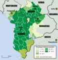
Карта розселення албанців на території т.зв. Великої Албанії
Summary
[edit]| DescriptionAlbanian-population.png |
English: Map of the ethnic Albanian population according to what was proposed by the Slavs (Serbia-Montenegro and Macedonia of Nord) and Greeks (Greece), which for the Albanians does not correspond to the truth (the Orthodox Albanians in the South are considered "Greek" by the Greek State and equally the Albanian-speaking populations of Macedonia and Serbia-Montenegro are diminished in number). |
| Date | |
| Source | Own work |
| Author | StrumicaBG |
Licensing
[edit]I, the copyright holder of this work, hereby publish it under the following license:
This file is licensed under the Creative Commons Attribution-Share Alike 3.0 Unported license.
- You are free:
- to share – to copy, distribute and transmit the work
- to remix – to adapt the work
- Under the following conditions:
- attribution – You must give appropriate credit, provide a link to the license, and indicate if changes were made. You may do so in any reasonable manner, but not in any way that suggests the licensor endorses you or your use.
- share alike – If you remix, transform, or build upon the material, you must distribute your contributions under the same or compatible license as the original.
File history
Click on a date/time to view the file as it appeared at that time.
| Date/Time | Thumbnail | Dimensions | User | Comment | |
|---|---|---|---|---|---|
| current | 10:36, 8 November 2023 |  | 640 × 655 (429 KB) | Maconan (talk | contribs) | Reverted to version as of 16:42, 18 November 2018 (UTC) |
| 16:42, 18 November 2018 |  | 640 × 655 (463 KB) | Local hero (talk | contribs) | Reverted to version as of 18:15, 30 April 2012 (UTC) | |
| 16:42, 18 November 2018 |  | 640 × 655 (429 KB) | Local hero (talk | contribs) | Reverted to version as of 16:40, 23 February 2014 (UTC) | |
| 16:41, 18 November 2018 |  | 640 × 655 (463 KB) | Local hero (talk | contribs) | Reverted to version as of 05:40, 6 December 2014 (UTC) | |
| 16:38, 18 November 2018 |  | 640 × 655 (429 KB) | Local hero (talk | contribs) | Reverted to version as of 16:40, 23 February 2014 (UTC) | |
| 05:40, 6 December 2014 |  | 640 × 655 (463 KB) | Makoden (talk | contribs) | Reverted to version as of 18:15, 30 April 2012 | |
| 16:40, 23 February 2014 |  | 640 × 655 (429 KB) | MacedonianBoy (talk | contribs) | Corrections. 1. Name changes, imaginary and nationalistic names. 2. Data accuracy according to the last census in Macedonia The one who did this map obviously lacks knowledge. 1. Kumanovo region has less than 30% Albanians, 2. Prespa, less than 10%... | |
| 18:15, 30 April 2012 |  | 640 × 655 (463 KB) | Tm (talk | contribs) | Reverted to version as of 23:52, 21 December 2011 | |
| 09:37, 1 April 2012 |  | 640 × 655 (448 KB) | FilipVtori (talk | contribs) | Repairing the inaccuracy of the content of the image | |
| 23:52, 21 December 2011 |  | 640 × 655 (463 KB) | StrumicaBG (talk | contribs) |
You cannot overwrite this file.
File usage on Commons
The following 3 pages use this file:
File usage on other wikis
The following other wikis use this file:
- Usage on fr.wikipedia.org
- Usage on hr.wikipedia.org
- Usage on no.wikipedia.org
- Usage on pl.wikipedia.org
- Usage on pt.wikipedia.org
- Usage on uk.wikipedia.org
- Usage on www.wikidata.org
Metadata
This file contains additional information such as Exif metadata which may have been added by the digital camera, scanner, or software program used to create or digitize it. If the file has been modified from its original state, some details such as the timestamp may not fully reflect those of the original file. The timestamp is only as accurate as the clock in the camera, and it may be completely wrong.
| Horizontal resolution | 37.8 dpc |
|---|---|
| Vertical resolution | 37.8 dpc |